

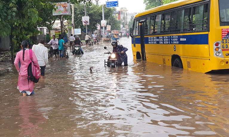
The vulnerability of the subcontinental urban shelf has been laid bare by a continuous monsoonal cloudburst. An intense meteorological depression lashing central and eastern Uttar Pradesh since early Friday night has exposed a systemic infrastructure failure across the capital district. As primary concrete grids transform into high-velocity surface streams, environmental scientists warn that the resulting damage is heavily magnified by the permanent sealing of natural floodplains and biodiversity-rich catchment basins like Bakshi Ka Talab. TreeTake delivers a comprehensive, field-verified data report on this structural crisis, examining the record-breaking rainfall telemetry, the ecological degradation of critical avian habitats, and the urgent implementation of mandatory permeable urban infrastructure quotas.
TreeTake Network
A devastating, continuous cloudburst spell has organised a complete paralysis of normal life across the state capital and surrounding regional districts. Triggered by an intense weather system that intensified early on Friday night, the extreme precipitation has continued for over forty hours without intermission, delivering over fifty times the normal daily rainfall quota for September. While the administrative machinery struggles to cope with the severe waterlogging, environmental analysts and town planners warn that the catastrophic flash flooding is not merely a meteorological anomaly. Instead, the crisis represents a direct, structural failure driven by rapid concrete expansion over natural catchments, permanently suffocating the region’s primary biological drainage networks.
The Inundation Metrics and State Interventions
The operational parameters monitoring regional hydrology registered an unprecedented escalation as federal relief cells compiled field reports from the ongoing monsoon surge. Meteorological observatories logged a staggering 135.8 millimetres of rainfall within a single twenty-four-hour window, marking the heaviest single-day deluge recorded during the current monsoon season. The structural impact across the broader state shelf has been widespread, with multiple districts reporting rainfall metrics significantly above the historic normal quota, causing extensive damage to standing rural crops and triggering the structural collapse of over one hundred residential properties.
The systemic concretion of natural low-lying plains has caused high-velocity accumulation along primary administrative avenues. Non-permeable urban design has forced water columns to breach municipal barriers, inundating residential blocks in low-lying extensions. In response to the immediate public safety threat, state executives placed all regional magistrates on high alert. Emergency rescue networks deploying specialised response cells have managed to evacuate scores of families from vulnerable structures, while district administrations implemented immediate institutional adjustments, ordering the complete closure of all schools, technical colleges, and higher education centres.
The Biological Loss Across Bakshi Ka Talab Catchments
The most critical ecological casualty of this unchecked infrastructure model is unfolding across the peri-urban borders of the capital district. The Bakshi Ka Talab sector, historically recognised as a highly fertile, biodiversity-rich network of natural seasonal pools, marshes, and multi-cropped alluvial plains, has faced a severe structural breakdown. The continuous paving over of these low-lying terrains to accommodate massive residential layouts and economic transit grids has effectively wiped out the landscape's natural retention capacity.
Field evaluations executed by landscape ecologists confirm that the permanent erasure of these designated rural carbon sinks has completely blocked the natural passage of excessive stormwater. Rather than soaking into porous soil matrices and recharging deep regional aquifers, the rainfall runs off the concrete slabs as high-velocity surface water, overwhelming local stream paths and completely flooding the remaining wild habitats. Conservationists track a deeply disturbing pattern where the destruction of seasonal wetlands has initiated an immediate collapse in localised biodiversity registers, permanently destroying the foraging spaces of indigenous waterbirds and resident raptors while triggering severe, unfixable topsoil erosion loops across the entire northern catchment basin.
The Institutional Testimony and Public Resistance
The interface between state tracking systems, environmental experts, and affected communities provides a clear picture of this administrative crisis. Meteorological specialists maintain that the prolonged monsoon spell is driven by an intense low-pressure system, but stress that the localised flooding is entirely man-made.
The current weather system has caused unprecedented rain accumulation across central districts, but tracking indicates that the record-breaking waterlogging is due to the complete absence of natural soil absorption layers, stated an official attached to the state-run India Meteorological Department during an operational briefing on the weather bulletin. The official clarified that the weather system, caused by a deep depression, is expected to enhance rainfall activity across the territory before the system gradually weakens.
This baseline scientific assessment is supported by senior environmental planning experts who point out that modern real-estate deployment completely ignores subcontinental drainage history. The rapid concretion of natural floodplains represents a short-sighted destruction of foundational ecological security because concrete surfaces prevent the natural infiltration of rainfall into subsurface strata, explained environmental scientist Dr Ashutosh Tripathi during a technical review of regional hydrological models. Tripathi emphasised that by prioritising short-term commercial layouts over natural water paths, the administration has turned thousands of acres of fertile catchment land into an artificial waterlogging zone that no layout modifications can easily resolve.
The ground-level impact has drawn sharp resistance from local residents who are facing the direct consequences of this engineering failure. Residents have been confined to upper floors for two days without electricity or clean water, because the local roads have turned into deep, rapid streams, argued Amit Gupta, a local resident living in an inundated peri-urban colony. Gupta stressed that municipal development bodies routinely approve high-density commercial layouts without checking basic sewage capacity blocks. The authorities continue to sell these models on paper, but the reality on the ground is that the complete absence of open soil layers has gridlocked daily life, destroying vehicles and homes while the public administration offers nothing but delayed advisory briefs.
Strategic Outcomes and Lessons to Learn
Dismantling the systemic failures gridlocking regional climate resilience demands an immediate transition from reactive disaster management to unyielding ecocentric urban planning. The primary lesson to learn from this ongoing inundation is that traditional engineering models cannot substitute for the complex ecosystem services provided by natural soil matrices and seasonal wetlands. Municipal development frameworks must be statutorily banned from approving new concrete infrastructure or mega-township expansions within designated wetland buffers and peri-urban biodiversity reservoirs like Bakshi Ka Talab.
First, the state environment department must legally mandate the integration of high-resolution, unalterable satellite telemetry to map and freeze all existing natural catchments, rendering any unauthorised concretion by construction syndicates a severe statutory offence. Second, town planning wings must transition to porous infrastructure designs, integrating mandatory green infrastructure quotas—including permeable asphalt pavements, bioswales, and open-earth public parks—to ensure that a minimum of thirty per cent of all urban surfaces remain capable of natural groundwater infiltration. Finally, the central government must introduce a unified, fast-track fiscal ledger that links project funds directly to verified aquifer health metrics and wetland survival rates, forcing municipal bodies to finance automated closed-drainage modernisations and state-wide catchment rejuvenation loops, thereby engineering absolute long-term accountability into the foundational tier of subcontinental development.



Leave a comment