

TreeTake Network
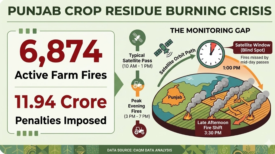
Official enforcement data compiled by the Commission for Air Quality Management has confirmed that Punjab recorded 6874 active stubble-burning incidents as of November 22, 2026, despite seasonal harvesting nearing absolute completion across the region. Field inspection teams dispatched to verify thermal coordinates confirmed actual open-air crop residue burning at 2704 specific farming sites out of 6425 inspected locations. The statutory disclosures arrive amidst an intensifying scientific debate surrounding severe discrepancies between traditional polar-orbiting satellite tracking systems and real-time ground realities, with independent analytical bodies warning that a significant portion of agricultural fires escape formal verification parameters due to altered burning schedules.
The agricultural residue crisis persists even though harvesting operations have concluded across 99.10pc of Punjab's total 32.87 lakh hectares dedicated to paddy cultivation. In response to the widespread non-compliance, environmental authorities have scaled up punitive measures, imposing formal environmental compensation penalties totaling 11.94 crore rupees across 2372 documented violations. However, administrative recovery frameworks continue to experience delays, with only 4.27 crore rupees successfully collected from non-compliant landholders so far, highlighting systemic friction in regional regulatory enforcement.
Altered agricultural schedules bypass standard orbital tracking windows
A technical assessment conducted via multi-sensor geostationary observations indicates that the official numbers represent a conservative underestimate of the atmospheric damage. Traditional tracking frameworks rely on polar-orbiting satellite passes that occur strictly between 10:30 AM and 01:30 PM each day. In an effort to avoid immediate detection by passing orbital sensors, local cultivators have systematically reorganised their burning patterns, delaying field ignition until after 03:00 PM.
This behavioral adaptation means that short-duration, high-intensity fires peak precisely during the late afternoon and evening hours, completely bypassing the primary monitoring windows of the standard institutional tracking systems. This temporal shift distorts the factual basis of seasonal clean-air programmes and undermines the integrity of regional pollution forecasting models.
"The current reporting protocols are failing to capture the absolute volume of emissions because our primary orbital infrastructure is blind to evening activity," explained Chandra Bhushan, Chief Executive Officer of the International Forum for Environment, Sustainability and Technology. "By tracking only the mid-day windows, our air quality models are utilising heavily sanitised baseline metrics that do not match the real-time degradation of the airshed."
District administrative performance and regional enforcement imbalances
A localized breakdown of the enforcement data exposes massive variations in compliance across the separate agrarian boundaries of the state. Ferozepur recorded the highest absolute concentration of agricultural fires with 892 confirmed violations, closely followed by industrial farming hubs like Sangrur with 787 cases and Tarn Taran with 710 incidents. Distant districts like Bathinda and Patiala registered 631 and 441 violations respectively, showing that the practice remains heavily internalised across both the northern and southern agricultural belts.
To curb this persistent trend, police divisions have registered 2066 formal First Information Reports under Section 223 of the Bharatiya Nyaya Sanhita against non-compliant parties. Additionally, state revenue officials have executed restrictive red entries within the official land titles of 2200 property files to penalise persistent violators through financial disqualification from agricultural credit loops.
"We have initiated formal prosecution proceedings against administrative supervisors in 41 instances where ground monitoring guidelines were actively ignored," stated Rajesh Kumar Verma, a senior monitoring official attached to the regional air quality cell. "However, the institutional focus must move beyond individual penalties toward ensuring that our nodal personnel are equipped to verify late-afternoon field clearances before smoke columns cross regional borders."
Editor's Note
The persistent gap between satellite data and actual ground emissions in Punjab reveals a structural failure in India's clean-air monitoring framework. Relying on rigid mid-day satellite passes creates an enforcement blind spot that farmers have naturally utilised to bypass regulation. Imposing financial compensation and recording land penalties is an incomplete solution if the underlying data architecture undercounts the true scale of the emissions by missing evening fires. The Commission for Air Quality Management must urgently modernise its observation grid by integrating continuous geostationary data and nocturnal sensors into its reporting matrix, turning data collection into a dynamic, round-the-clock intervention tool.



Leave a comment