

TreeTake Network
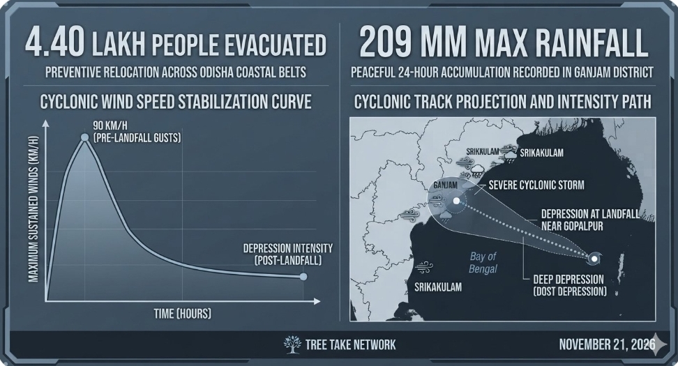
The severe weather threat to the eastern coast of India has significantly abated as the remnant of Severe Cyclonic Storm Akvan rapidly lost its structural intensity, weakening into a depression over south coastal Odisha. The India Meteorological Department confirmed that the system completed its volatile land interaction after making landfall near Gopalpur on November 21, 2026, bringing historic rainfall volumes but causing no major structural damage or loss of human life across the vulnerable coastal belt. The state machinery has officially ruled out any immediate major flood threat despite continuous localised downpours, attributing the successful outcome to the timely, massive preventive evacuation of over 4.40 lakh people to heavily fortified cyclone shelter structures.
Rapid Depolarisation of Severe Weather Threat
Atmospheric tracking monitors revealed that the cyclonic system could not maintain its catastrophic potential during the final approach phase due to the stabilising influence of land interaction and a notable drop in sea surface temperatures near the coast. The storm crossed south coastal Odisha and adjoining north Andhra Pradesh between 0730 hours and 0830 hours with maximum sustained wind speeds fluctuating between 70 and 80 kilometres per hour, peaking with gusting intervals of 90 kilometres per hour before collapsing into a deep depression. Specialised meteorologists noted that the system is tracking north-northeastwards systematically and is projected to transform into a well-marked low-pressure area within the next six hours.
"The system failed to sustain its peak destructive intensity because it encountered a relatively cold sea surface layer as it moved closer to the southern shoreline," stated Dr Mrutyunjay Mohapatra, Director General of the India Meteorological Department. "This thermodynamic stabilisation substantially suppressed the core convective mechanism of Akvan before the exact window of landfall, sparing the region from extreme storm surge impacts. However, the residual moisture plume remains massive, producing record-breaking precipitation anomalies across northern Odisha, Jharkhand, and Gangetic West Bengal."
Extreme Downpour Anomalies and Inundation Realities
Despite the rapid deceleration of surface wind speeds, a continuous deluge has severely disrupted the regional urban infrastructure, causing severe waterlogging and flash inundation across multiple low-lying residential sectors. Intense precipitation gauges managed by localised hydro-met networks registered staggering 24-hour accumulations ending this morning. Patrapur in Ganjam district emerged as the wettest location with 209 millimetres of rain, closely followed by Hinjili at 207 millimetres and the primary landfall zone of Gopalpur tracking at 190 millimetres. In neighbouring Andhra Pradesh, Srikakulam district bore the brunt of the initial outer-band impact, where 16 monitoring stations logged rainfall figures exceeding 100 millimetres in a single night.
"Our primary operational challenge shifted immediately from wind-hazard management to localized inundation control within hours of the landfall sequence," reported Suresh Pujari, Odisha Disaster Management and Revenue Minister. "While the systemic flood threat across major river basins is entirely non-existent, the relentless rain caused immediate waterlogging across Berhampur, particularly impacting vulnerable colonies like Gajapati Nagar and Nilachal Nagar. We successfully managed the preemptive movement of 3.72 lakh citizens in the highest-risk coastal pockets, including 4467 expectant mothers who were safely relocated to dedicated institutional healthcare hubs."
War-Footing Clearance and Restoration Mobilisation
Multi-agency emergency deployment networks have swarmed the affected coastal geography to restore critical arterial connectivity and clear massive debris fields. Teams from the Odisha Disaster Rapid Action Force have initiated high-intensity tree-cutting operations across blocked communication passages, utilizing specialized heavy machinery to clear uprooted trunks beneath the critical Jarau Nal bridge near Chhandikendu village. Simultaneously, administrative wings confirmed that rapid restoration protocols have allowed a swift return to normalcy along the tourism zones of Puri beach, where commercial beachside activity officially resumed this afternoon following a comprehensive safety clearance.
"The strategic deployment of tactical personnel allowed us to clear primary transportation grids within hours of the storm's passage," stated Prakhar Jain, Managing Director of the Andhra Pradesh State Disaster Management Authority. "While light to moderate rainfall is expected to persist across the North Andhra region throughout the evening, the core risk has transitioned. Maritime restrictions are being systematically reviewed, though we continue to advise fishermen against venturing into the northwest Bay of Bengal until the residual sea conditions fully stabilize."
Editor's Note
The successful management of Cyclone Akvan underscores a monumental evolution in regional meteorological forecasting precision and proactive disaster governance. By executing a flawless evacuation of nearly half a million citizens based on early predictive modelling, administrative bodies have effectively institutionalised a zero-casualty paradigm for severe coastal disturbances. The strategic way forward must now prioritise the urgent modernisation of urban drainage systems in tier-two coastal cities like Berhampur to counter the shifting nature of cyclones, which increasingly manifest as extreme precipitation hazards rather than pure wind storms. Integrating climate-resilient stormwater infrastructure will be essential to mitigating localised economic stagnation during subsequent multi-district inundation events.



Leave a comment