

The catastrophic ecological consequences of the massive rock-and-ice avalanche that struck the Langtang Lirung peaks in Nepal continue to multiply across international boundaries. While rescue teams manage the high human toll in the upper mountain folds, high-resolution satellite remote sensing has exposed a slower, systemic environmental disaster flowing directly into the plains of northern India. The sudden arrival of millions of tonnes of glacial mud, pulverised rock debris, and destroyed infrastructure fragments has triggered unprecedented riverbed siltation across critical trans-border aquatic networks. TreeTake presents a detailed operational report on this trans-boundary ecological emergency, examining the satellite telemetry data tracking sediment deposition, the acute threat to vulnerable wetland ecosystems, and the urgent mobilisation of multi-agency hydraulic engineers.
Geospatial Tracking and Riverbed Sedimentation Metrics
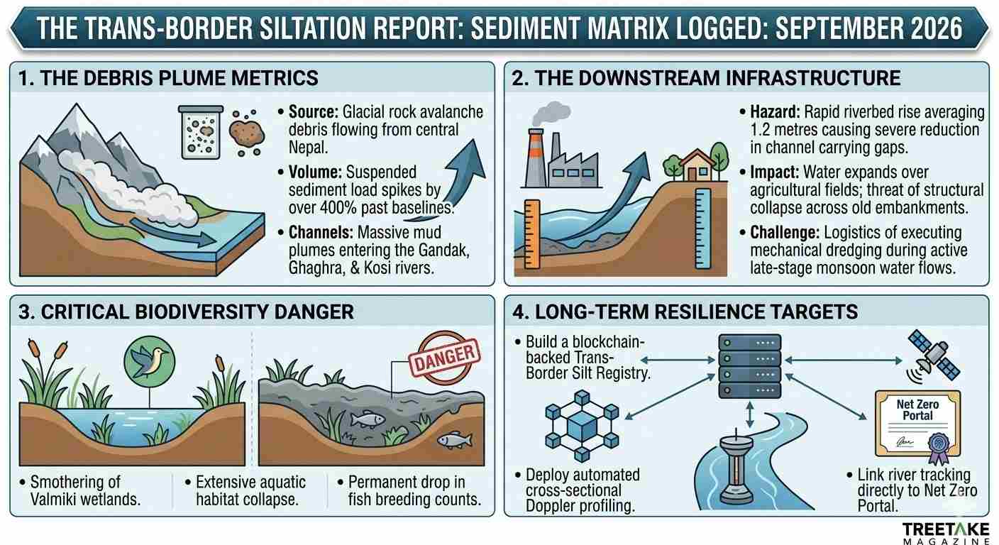
The operational parameters governing subcontinental river basin monitoring underwent an immediate, technical escalation on Wednesday, 23 September 2026, as space-borne sensors verified a dramatic spike in turbidity values across the Indo-Gangetic drainage plain. Utilising multi-spectral imaging arrays from India’s advanced remote sensing networks, hydrologists mapped a massive plume of suspended sediment moving out of the Nepalese river systems into the Gandak, Ghaghra, and Kosi river channels. The field logs indicate that the sudden influx of upstream mud has completely overwhelmed the natural sediment-carrying capacities of these primary trans-border arteries, causing extensive, immediate deposition along low-lying river beds.
The satellite tracking charts confirm that the average suspended sediment load across the northern plains has spiked by over four hundred per cent compared to standard seasonal baseline values. This unscientific accumulation of debris has caused a critical, rapid reduction in deep-channel carrying capacities, forcing water levels to expand outward over delicate agricultural boundaries even during moderate discharge phases. Specialised hydraulic engineering teams deploying acoustic Doppler current profilers have verified that regional riverbeds have risen by an average of 1.2 metres within less than seventy-two hours, setting the stage for prolonged waterlogging across the peri-urban borders of Bihar and eastern Uttar Pradesh.
Official Monitoring Mandates and Downstream Counter-Measures
The central environment ministry has issued strict directives to regional water resources departments to execute continuous, automated cross-sectional profiling rather than relying on obsolete manual sounding methods. State conservation architects maintain that real-time sediment tracking is a non-negotiable requirement to prevent widespread infrastructure collapse and safeguard regional biosecurity. "The transboundary movement of this glacial debris represents a major structural challenge to our downstream flood protection layouts, and we are mobilising our highest level of technological monitoring to stabilise these channels," announced a senior technical director within the Central Water Commission during an emergency operational briefing on Wednesday, 23 September 2026. He clarified that regional teams are working to install advanced automated dredging systems at critical choke points. "Our primary focus is ensuring unrestricted flow paths by deploying real-time telemetry, reinforcing fragile embankment matrices, and executing immediate channel-clearing operations before winter silt consolidation locks the river morphology."
This aggressive state intervention has faced logistical resistance from regional river management boards and local irrigation engineers who point out that the sheer volume of incoming material exceeds the capacity of existing subcontinental dredging infrastructure. Field teams warn that attempting to execute massive mechanical dredging during late-stage monsoon flows introduces severe structural risks to older bridge pylons and embankment foundations. "The telemetry data showing massive silt accumulation across the Gandak basin highlights an unprecedented logistical crisis that cannot be resolved through routine engineering tools," noted a regional executive engineer responsible for border water management on Wednesday, 23 September 2026. He emphasised that the downstream staff is severely overstretched, attempting to manage localised embankment stabilisation while tracking the continuous influx of mud. "If the upstream sediment delivery remains unmitigated, the pressure on our regional drainage networks will cause widespread waterlogging across agricultural fields that could destroy the upcoming winter crop cycle."
Severe Wetland Degradation and Aquatic Habitat Collapse
The downstream migration of the Himalayan debris introduces a catastrophic threat to the region's protected wetland ecosystems, functioning as a severe smothering layer over critical aquatic habitats and fish breeding grounds. The continuous deposition of fine glacial clay and pulverised rock silt has completely blanketed the bottom layers of regional oxbow lakes and seasonal pools, cutting off sunlight and leading to an immediate collapse in localised biological productivity.
"The rapid concretion of these trans-border riverbeds has triggered an extensive, unfixable collapse in our aquatic biodiversity registers," noted Dr Ashutosh Tripathi, a senior geospatial analyst specialising in subcontinental riverine health indices, during an environmental evaluation session on Wednesday, 23 September 2026. He highlighted that the high turbidity has led to widespread fish mortality and destroyed the specific nesting grounds used by vulnerable resident and migratory waterbirds across the Valmiki-Chitwan corridor. "The administration is focusing entirely on structural public works, celebrating token embankment reinforcements while ignoring the destruction of the biological systems that naturally filter our water. By suffocating the foundational tier of our wetland food webs, this siltation crisis is driving a localised ecological collapse that no amount of engineering can reverse."
Strategic Pathways to Catchment Resilience
Dismantling the systemic risks gridlocking transboundary river management requires a total transformation of subcontinental catchment planning and ecological governance. First, the Ministry of Environment must formalise a unified, blockchain-backed Trans-Border Siltation Registry, forcing all regional infrastructure developers to log real-time turbidity data and automated sediment tracking metrics directly onto a public server. Second, regional planning wings must introduce a strict statutory ban on unauthorised sand mining and unscientific embankment modifications, ensuring that rivers retain their natural flood-pulsing capacities to flush out upstream debris. Finally, the central government must establish decentralised, state-backed ecological restoration task forces empowered to deploy biological filtering techniques—such as extensive reed-bed planting and natural wetland buffer zones—ensuring that long-term environmental sustainability is engineered directly into the foundational tier of subcontinental water governance.



Leave a comment