

The multi-billion-rupee urban sprawl of Uttar Pradesh's capital district is set to face a critical ecological boundary check. As the Lucknow Development Authority prepares the final administrative registries for the simultaneous launch of its most ambitious residential schemes—the sprawling Varun Vihar Yojna near the Agra Expressway and the massive Naimish Nagar Yojna on the Sitapur Road corridor—the frontline of environmental defence has shifted onto the fragile floodplains and peri-urban biodiversity buffers of northern Lucknow. The dual schemes, designed to open online registration for thousands of residential plots on Thursday, 24 September 2026, represent a massive structural conversion of thousands of acres of rural agricultural and wetland ecosystems into a concrete smart-city infrastructure grid. TreeTake presents a comprehensive operational update on this impending urban intervention, examining the high stakes of ecological clearance bottlenecks, the permanent destruction of double-cropped agricultural soils, and the expert demands for strict post-project scientific compliance audits.
The Scale of the Urban Spill and Structural Layouts
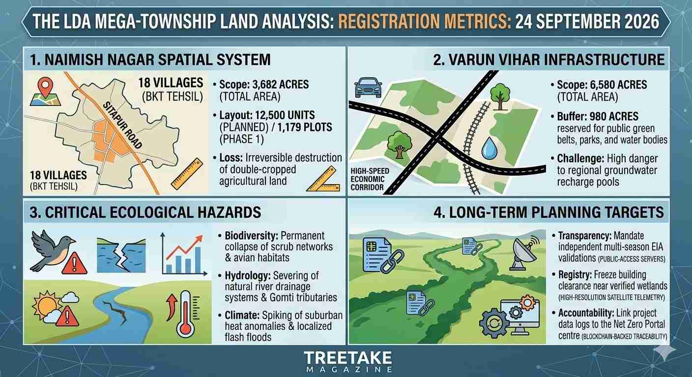
The baseline parameters governing the spatial layout of northern Lucknow are facing an unprecedented, permanent modification as the state executive coordinates the formal foundation stone events for the authority's flagship townships. The dual roll-out represents the largest state-backed residential expansion executed in recent memory. The Varun Vihar Yojna is mapped out to encompass an astronomical 6,580 acres of land along the Agra Expressway corridor, while the model township of Naimish Nagar Yojna incorporates 3,682 acres across 18 villages within the Bakshi Ka Talab tehsil area. Combined, the initial phases open registration for over 3,105 residential plots, targeting a planned population influx of over three lakh citizens into sectors that currently function as critical open green spaces and rural agrarian buffers.
The core of the environmental friction turns on the extensive land conversion methodology, which relies on direct, consent-based acquisition and cash payments to farmers rather than traditional land pooling models. While this accelerated fiscal model avoids the protracted legal gridlock of land-pooling lotteries, it allows heavy construction machinery to systematically clear massive tracts of continuous scrub forests, micro-wetlands, and local natural drainage channels before comprehensive multi-season biodiversity logs are completed. Environmental field surveys indicate that the rapid integration of villages like Purwa, Kamalabad, and Barumau into the urban grid will permanently dismantle the natural drainage vectors feeding the tributaries of the Gomti River basin, forcing low-lying areas into severe hydrological vulnerability during erratic late-stage monsoon deluges.
The Permanent Loss of Fertile Alluvial Soils
The environmental cost of this spatial spill is heavily compounded by the permanent erasure of some of the most productive agricultural tracts in the central plains. Unlike arid waste zones, the terrain targeted across the Bakshi Ka Talab belt consists of highly fertile, multi-cropped alluvial soils that have sustained complex rural agricultural economies for generations. The conversion of these double-cropped fields into asphalt roads and concrete foundations represents a permanent loss of regional food security assets and localised topsoil networks.
"The irreversible paving over of thousands of hectares of prime, multi-cropped agricultural land across eighteen contiguous villages represents a short-sighted destruction of our foundational ecological security," stated Dr Ashutosh Tripathi, a senior soil scientist specialising in subcontinental landscape indices. He emphasised that the localised topsoil layers, which take thousands of years to accumulate their dense nutrient structures, are being systematically scraped away by heavy earth-moving equipment within days. "When you replace highly porous, active agricultural soils with non-permeable concrete slabs, you are not merely changing a land use category on a municipal ledger. You are permanently suffocating the natural biological activity of the earth and creating an unyielding block that prevents rainfall from recharging our deep regional aquifers, forcing the entire district into structural water scarcity."
Official Sustainability Claims and Developer Discursive Frameworks
The publication of the initial township layouts has drawn quick, defensive arguments from regional planning directors who maintain that modern public housing designs successfully engineer sustainability into their core frameworks. The Lucknow Development Authority asserts that the new schemes represent a major transition toward balanced urban growth under the State Capital Region framework, purposefully designed to prevent haphazard, unauthorised suburban settlements that lack proper scientific waste systems. "We are balancing the massive, inevitable housing demands of a fast-growing state capital with responsible environmental planning, and our layouts incorporate modern green infrastructure that sets a new national standard," stated Anoop Kumar Misra, a senior urban planning director within the authority's engineering wing during a technical briefing on the project's master roads system. He emphasised that the mega-townships are legally structured to allocate large spaces to dedicated ecological zones. "The Varun Vihar layout explicitly designates over 980 acres exclusively for green belts, public parks, and preserved water bodies, while Naimish Nagar incorporates modern solid waste management facilities and centralised sewage treatment plants, ensuring that urban development does not compromise regional groundwater purity."
This official narrative has faced sharp opposition from independent environmental litigators and local citizen conservation networks, who argue that artificial green belts inside a high-density concrete township cannot replace the complex ecosystem services of natural land. Critics point out that under the Environmental Impact Assessment Notification, mega-housing projects exceeding specified spatial thresholds must secure rigorous, independent prior clearances, yet local enforcement wings frequently tolerate structural non-compliance during the foundational phases. "The administrative practice of accelerating online registration and site office completions before the finalization of comprehensive, public-access post-project compliance reviews creates a dangerous legal precedent," noted Vibhor Gauba, a senior environmental advocate practising before the National Green Tribunal. He warned that once thousands of individual plots are allotted via public lottery, reversing layout damage to local aquifers becomes practically impossible. "We are looking at an artificial planning paradigm where the actual destruction of natural carbon sinks is masked by superficial public relations metrics. If we allow these projects to concrete over thousands of acres of peri-urban wetlands without an independent, multi-disciplinary biological audit, the capital district will face an unmanageable thermal and hydrological crisis within the decade."
Severe Habitat Fragmentation and Avian Population Collapse
The structural conversion of northern Lucknow’s open landscape introduces a catastrophic threat to the region's indigenous biodiversity, functioning as a severe fragmentation barrier across ancient avian and small-mammal migratory pathways. The continuous clearance of high-density scrub networks, native tree clusters, and seasonal pools has completely dismantled the micro-habitats that support vulnerable regional wildlife, leading to an immediate collapse in localised ecological diversity.
"The rapid concretion of these contiguous rural zones has triggered an extensive, unfixable collapse in our regional biodiversity registers," noted Shanal Khullar, a field coordinator attached to a prominent subcontinental wildlife conservation foundation. She highlighted that the ongoing destruction of tall grasses, indigenous acacia patches, and seasonal pools has led to a dramatic drop in nesting counts for resident waterbirds and local raptor species across the northern peri-urban belt. "The administration is hiding behind superficial green labels, creating manicured public parks while simultaneously clearing the complex wild scrub networks that actually sustain our native fauna. By forcing wild species out of their natural foraging ranges into increasingly hostile urban fragments, we are actively driving a localised extinction event that no amount of cosmetic urban landscaping can ever resolve."
The Silvicultural Critique and Thermal Regulation Failures
The massive scale of the BKT tehsil conversions has revived an intense, high-stakes academic debate among regional ecologists and subcontinental resource experts regarding the ultimate carrying capacity of Lucknow’s suburban ecosystems. Independent researchers utilising Leopold Interaction Matrices to evaluate housing project footprints have demonstrated that the rapid removal of topsoil, native trees, and seasonal pools spikes local ambient temperatures and permanently severs the groundwater-river recharge loop.
"The simultaneous insertion of thousands of concrete residential structures into our remaining northern green lungs exposes the fundamental ecological limitation of current municipal planning models," argued Dr Alok Ranjan, a senior conservation scientist specialising in subcontinental landscape dynamics. He emphasised that superficial urban greening, such as lining public highways with ornamental shrubs, does nothing to absorb heavy particulate matter or preserve local avian nesting habitats. "When you clear thousands of acres of high-biodiversity rural land across eighteen contiguous villages, you are permanently destroying the thermal regulation capacities of the entire capital district. Natural floodplains and rural scrub networks are not empty real estate assets waiting for concrete plotting; they are living hydrological shock absorbers. Unless the authority immediately mandates comprehensive multi-agency carbon footprint modelling before any further spatial clearings are arbitrated, the long-term cost of urban heat anomalies and localised flash floods will completely wipe out the economic gains of these new smart cities."
Strategic Pathways to Urban Sustainability
Dismantling the systemic environmental risks gridlocking local urban expansion requires an immediate overhaul of development approval protocols. First, the State Environment Department must legally mandate the integration of high-resolution, unalterable satellite telemetry to freeze the land-use baselines of all high-priority peri-urban water systems, rendering any unauthorised modifications by construction crews a non-bailable criminal offence. Second, local development bodies must be statutorily banned from entering the public registration phase until a complete, multi-season Environmental Impact Assessment is hosted on public-access servers for a minimum of sixty days, ensuring transparent data verification. Finally, the central government must introduce a unified, blockchain-backed National Digital Traceability System for urban infrastructure projects, forcing developers to submit to independent, annual ecological audits that link project funds directly to verified tree survival rates and aquifer health metrics, thereby engineering absolute long-term accountability into the foundational tier of subcontinental development.



Leave a comment