

Tell-All
We asked: Is rampant paving of natural waterbodies like Ekana Lake and Bakshi ka Talab causing urban floods?
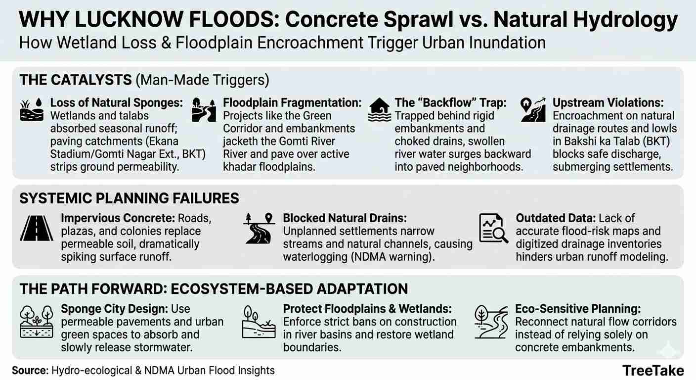
Rampant paving and encroachment of natural waterbodies—including wetlands, floodplains, and catchments like the Ekana Stadium area (Gomti Nagar Extension) and Bakshi ka Talab (BKT)—are the definitive catalysts behind the recent, severe urban floods in Lucknow. While climate anomalies and heavy upstream discharges from the Gomti River trigger sudden inflows, the scale of urban inundation is largely man-made. The hydro-ecological impact: • Loss of Natural Sponges: Historically, wetlands and talabs (ponds) functioned as natural hydrologic sponges. They absorbed millions of litres of seasonal runoff and replenished the water table. Converting these low-lying water catchments into concrete roads, stadium parking zones, commercial plazas, and residential colonies permanently strips the terrain of its permeability. 1- Floodplain fragmentation: Large infrastructure projects, such as the Green Corridor and structural embankments near the Ekana Stadium and Phoenix Palacio corridor, have drastically altered the river basin’s topography. By jacketing the riverfront and paving over the active khadar (floodplain) areas, the natural flood channels have been heavily restricted. 2- The "backflow" trap: When the river swells, water can no longer spread naturally across its original floodplains. Instead, trapped behind rigid embankments and choked drainage outlets, the water surges backwards into paved urban pockets. This was precisely witnessed when floodwaters inundated local neighbourhoods, major service lanes, and commercial sectors even without localised downpours. 3- Upstream violations: In regions like Bakshi ka Talab, systemic encroachment on natural drainage routes and agriculture-heavy lowlands prevents water from discharging safely. This subjects dozens of low-lying settlements to severe, multi-day submersions. Systemic planning failures: The crisis is exacerbated by poor urban planning that prioritises construction over ecological balance. Many municipalities lack accurate flood-risk maps and digitised drainage inventories, making it difficult to model urban runoff. Traditional flood control measures, such as larger drains and embankments, are no longer sufficient. Impervious surfaces and drainage obstruction: Rapid urbanisation has replaced permeable land with impervious surfaces like roads, pavements, and buildings. This transformation reduces the ground’s ability to absorb rainfall, significantly increasing surface runoff. Additionally, natural drainage channels and smaller streams feeding these water bodies are often blocked or narrowed by unauthorised settlements and unplanned housing colonies. This obstruction prevents stormwater from moving freely, leading to severe waterlogging even during short spells of rain. The National Disaster Management Authority (NDMA) highlights that such large-scale encroachments decrease the capacity of natural drains, directly resulting in flooding. Moving forward: Lucknow’s flooding proves that engineering cannot entirely override natural hydrology. Continuing to isolate infrastructure planning from the overall river system will keep exacerbating these disasters. To combat urban floods, the state must transition from aggressive concrete construction inside natural basins to eco-sensitive spatial planning, strict enforcement of wetland boundaries, and the restoration of natural, unobstructed flow corridors. Ecosystem-based adaptation: It includes restoring natural water bodies, enforcing strict bans on construction in floodplains, and implementing "sponge city" concepts with permeable pavements and urban green spaces to absorb and gradually release water. Without addressing the root cause of wetland loss and concrete sprawl, urban flooding will continue to intensify. -Dr Ravinder Pall Saini, I.F.S. (retd.), PhD. (Forest Entomology), MBA (HRM), Member, Board of Management, Forest Research University, Dehradun
When a city floods, our immediate response is often to look at its drainage systems and pumping infrastructure. But perhaps we should first look at what we have done to its natural water bodies. Lakes, ponds and wetlands are not vacant parcels of land waiting for development. They are essential components of a city's natural infrastructure, designed by nature to store, regulate and distribute water. The concerns surrounding Lucknow's Ekana wetland and the wider Bakshi Ka Talab region raise important questions about how urban expansion is affecting these natural systems. The loss, encroachment and alteration of ponds, wetlands and their connecting drainage channels can compromise the ability of an entire landscape to manage excess rainfall. I believe the first step towards addressing this problem should be scientific assessment rather than immediate construction or beautification. Technologies such as Geographic Information Systems (GIS), remote sensing and satellite imagery can help authorities understand how these water bodies have changed over time. Comparing historical satellite images can reveal shrinking water extent, encroachment, changes in vegetation and the expansion of built-up areas. However, mapping the surface alone is not enough. Bathymetric surveys should be conducted to understand the depth profile, sediment accumulation and actual storage capacity of lakes. Digital Elevation Models (DEM) can help identify surrounding catchments, natural slopes, feeder channels and the direction of surface runoff. After all, a lake cannot function effectively as a catchment if the natural pathways bringing water to it have been obstructed. This assessment should lead to a comprehensive urban waterbody inventory, with clearly demarcated boundaries, protected catchment areas and regular monitoring. Restoration should prioritise reconnecting natural drainage channels, managing pollution, controlling encroachments and protecting ecological habitats. Concrete embankments and recreational beautification should never come at the expense of a waterbody's natural functions. Urban planning approvals must also consider the cumulative impact of development on nearby waterbodies and their catchments. Protecting a lake while allowing its surrounding drainage network to disappear is not conservation. We have become increasingly efficient at constructing infrastructure to remove excess rainwater, while overlooking the natural infrastructure that has performed this function for centuries. We cannot protect what we have not properly mapped, and we cannot restore what we do not understand. Perhaps before asking how to drain a city, we should first understand how its landscape was designed to hold water.- Ar. Anand PJ, Architect, sustainable design enthusiast
The rampant paving, encroachment and concretisation of natural water bodies such as Ekana Lake and Bakshi Ka Talab raise a serious question: Are we developing our cities at the cost of their natural drainage systems? In my opinion, the answer is undoubtedly yes. Urban flooding is not merely the consequence of excessive rainfall or climate change. It is also the result of unplanned urbanisation, destruction of wetlands, encroachment upon traditional drainage channels and the disappearance of natural water-retention areas. Nature has its own drainage mechanism. Lakes, ponds, wetlands and low-lying areas act as natural reservoirs, absorbing excess rainwater and allowing it to percolate into the ground. They regulate groundwater levels, support biodiversity and reduce the intensity of flooding. When these natural water bodies are filled, narrowed or covered with concrete, rainwater loses its natural destination. Instead of being absorbed by the soil, it flows rapidly over paved surfaces, overwhelming stormwater drains and flooding roads, residential colonies and public spaces. The situation around Ekana Lake and Bakshi Ka Talab should therefore be examined with ecological sensitivity. Development activities must not compromise the natural capacity of these waterbodies to retain rainwater. A lake is not merely an attractive landscape feature or a piece of vacant land available for infrastructure development; it is an essential component of the city’s ecological infrastructure. Lucknow, like many rapidly expanding Indian cities, is experiencing increasing pressure from urbanisation. Roads, parking spaces, commercial complexes and residential constructions are replacing open spaces and permeable surfaces. The consequences become particularly visible during intense monsoon showers. I strongly believe that urban planning must adopt the principle of Nature-Based Solutions rather than relying exclusively on concrete infrastructure. The following measures deserve immediate attention: 1. Conduct a scientific survey and demarcation of all natural lakes, ponds, wetlands and traditional drainage channels. 2. Stop encroachment, indiscriminate filling and unnecessary concretisation of water bodies. 3. Restore degraded lakes and wetlands and preserve their natural catchment areas. 4. Promote rainwater harvesting, permeable pavements, green spaces and urban forests. 5. Undertake an independent environmental and hydrological impact assessment before approving major construction projects near water bodies. 6. Ensure strict implementation of existing environmental laws and accountability of the authorities concerned. As someone deeply concerned about environmental conservation and sustainable living, I feel that development should work in harmony with nature, not against it. A city needs roads and buildings, but it needs lakes, wetlands and open spaces even more. We must remember that water always finds its natural course. If we block that course, it will eventually find its way through our streets and homes. Let us not convert our natural water bodies into concrete structures and then spend public money managing the floods created by our own mistakes. Save Waterbodies, Save Groundwater, Save Lucknow. -Lion HN Singh, Lions International Faculty, Member SPHEEHA, HAM Radio Licensee, Trekker & Mountaineer, An admirer of mountains, nature, heritage and the timeless spirit of exploration
लखनऊ में पिछले कुछ वर्षों से हर बरसात में जलभराव और बाढ़ जैसी स्थिति बनना आम हो गया है। पहले यह समस्या केवल पुराने शहर और निचले इलाकों तक सीमित मानी जाती थी, लेकिन अब एकाना स्टेडियम, गोमती नगर विस्तार और बख्शी का तालाब जैसे नए और आधुनिक कहे जाने वाले क्षेत्रों में भी पानी भर जाता है। इसका सबसे बड़ा और गहरा कारण प्राकृतिक जल निकायों जैसे तालाबों, पोखरों, झीलों और दलदली जमीनों को मिट्टी डालकर पाट देना और उन पर निर्माण कर देना है। पहले शहर के चारों ओर सैकड़ों छोटे बड़े तालाब, पोखर और निचली जमीनें फैली हुई थीं। बरसात का अतिरिक्त पानी इन्हीं में जमा होता था। यह पानी धीरे धीरे जमीन के अंदर जाता था, जिससे भूजल स्तर भी बना रहता था और बचा हुआ पानी नालों और छोटी नदियों के माध्यम से गोमती नदी तक पहुंच जाता था। इस प्राकृतिक व्यवस्था के कारण शहर को बाढ़ से सुरक्षा मिलती थी। इन जल निकायों को प्रकृति का स्पंज कहा जाता था, क्योंकि ये पानी को सोखकर शहर को डूबने से बचाते थे। लेकिन तेजी से बढ़ती आबादी और शहरीकरण की दौड़ में इस प्राकृतिक सुरक्षा चक्र को तोड़ दिया गया। बख्शी का तालाब क्षेत्र कभी उपजाऊ खेतों, मौसमी तालाबों, दलदल और हरे भरे मैदानों का सुंदर जाल था। अब वहां बड़ी बड़ी आवासीय कॉलोनियां, शॉपिंग कॉम्प्लेक्स, सड़कें और औद्योगिक क्षेत्र बन गए हैं। इसी तरह एकाना, सीजी सिटी और गोमती नगर विस्तार के आसपास गोमती नदी के बाढ़ मैदान और निचली जमीनों को मिट्टी से भरकर समतल किया गया और उस पर कंक्रीट बिछा दी गई। जब जमीन पर कंक्रीट और तारकोल बिछ जाता है तो बारिश का पानी जमीन में बिल्कुल नहीं जा पाता। वह तेजी से बहता हुआ नालों पर एक साथ दबाव डालता है। शहर के नाले पहले से ही अतिक्रमण, कचरे और अवैध निर्माण के कारण संकरे और बंद हो चुके हैं। ऐसे में थोड़ी तेज बारिश भी जलभराव का बड़ा कारण बन जाती है। गोमती नदी का प्राकृतिक बाढ़ मैदान भी सिकुड़ गया है, इसलिए नदी का बढ़ा हुआ पानी फैलने के लिए जगह न मिलने पर सीधे कॉलोनियों और सड़कों में घुस जाता है। विभिन्न अध्ययनों के अनुसार लखनऊ अपने अधिकतर पुराने तालाब और पोखर खो चुका है। कभी शहर में एक हजार से अधिक जल निकाय थे, अब बहुत कम बचे हैं। लखनऊ विश्वविद्यालय के भूविज्ञान विभाग के एक अध्ययन में पाया गया कि शहर में होने वाले जलभराव का एक बड़ा हिस्सा सीधे तौर पर जल निकायों के खत्म होने से जुड़ा है, जबकि बड़ा हिस्सा खराब ड्रेनेज व्यवस्था और बिना योजना के निर्माण से जुड़ा है। अक्टूबर 2026 में आई बाढ़ इसका सबसे ताजा और दर्दनाक उदाहरण है। गोमती नदी में पानी बढ़ने पर फैजुल्लागंज, बख्शी का तालाब, गोमती नगर विस्तार, शहीद पथ और एकाना स्टेडियम के आसपास के इलाके पानी में डूब गए। एकाना स्टेडियम जैसे आधुनिक क्षेत्र में पानी भरने से यह स्पष्ट हो गया कि केवल चैड़ी सड़कें, बड़े मॉल और नई इमारतें बनाने से शहर सुरक्षित नहीं होता, यदि पानी के प्राकृतिक रास्ते बंद कर दिए जाएं। उस समय प्रशासन को पानी निकालने के लिए दर्जनों पंप लगाने पड़े और अस्थायी बांध बनाने पड़े, लेकिन लोगों को भारी परेशानी उठानी पड़ी। हजारों परिवारों के घरों में पानी घुस गया, सामान खराब हो गया और जनजीवन ठप हो गया। इस समस्या का स्थायी समाधान भी प्रकृति के संरक्षण में ही छिपा है। सबसे पहले जो तालाब, पोखर और वेटलैंड बचे हैं, उन्हें पूरी तरह बचाना होगा और उन पर किसी भी तरह के अतिक्रमण को रोकना होगा। जो तालाब पाट दिए गए हैं, उनमें से संभव तालाबों को फिर से गहरा करके पुनर्जीवित किया जा सकता है। शहर के नालों और छोटी नदियों को साफ, चौड़ा और अतिक्रमण मुक्त रखना जरूरी है। गोमती और उसकी सहायक नदियों के बाढ़ मैदान में किसी भी तरह के निर्माण पर सख्त रोक लगनी चाहिए। हर नई आवासीय कॉलोनी और व्यावसायिक परियोजना में वर्षा जल संचयन और भूजल रिचार्ज सिस्टम को अनिवार्य बनाना चाहिए, ताकि बारिश का पानी नालों पर बोझ बनने के बजाय जमीन में जाए। यदि समाज, प्रशासन और निर्माण एजेंसियां मिलकर जल निकायों को बचाने का संकल्प लें तो लखनऊ में बाढ़ और जलभराव का खतरा काफी कम हो सकता है, भूजल स्तर सुधरेगा और आने वाली पीढ़ियों को एक सुरक्षित और संतुलित शहर मिल सकेगा। -डॉ. मोनिका रघुवंशी, लेखिका, पत्रकार एवम् सामाजिक कार्यकर्ता
Topic of the month: With no clear demarcation left between residential, semi-residential and commercial areas in most cities, do you think there’s a need to maintain nighttime silence and certain protocols to ensure everyone can enjoy a restful night without constant disturbance caused by honking horns and loading/unloading at warehouses/godowns? Send your views in no more than 500 words, in either Hindi or English, to [email protected] along with your recent photo and designation.


Leave a comment