

TreeTake Network
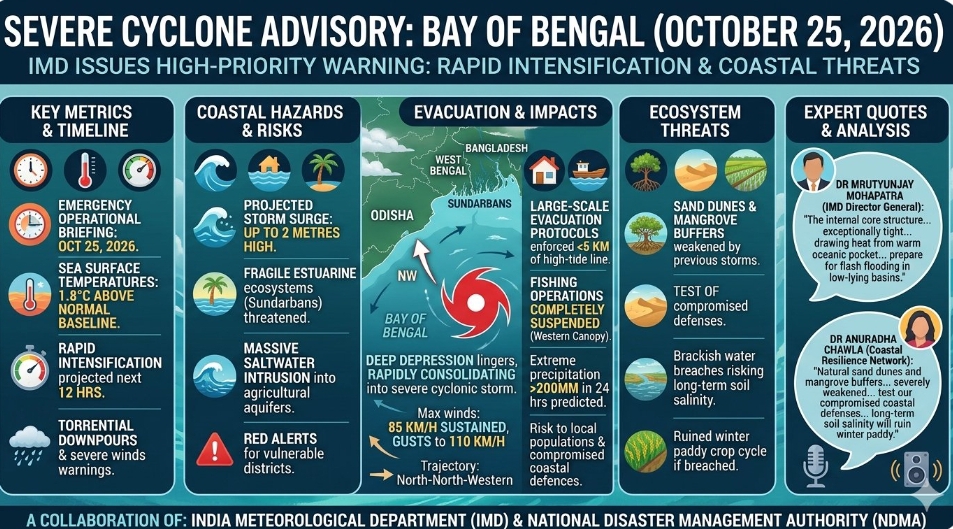
The India Meteorological Department (IMD) issued a comprehensive, high-priority meteorological advisory on October 25, 2026, warning that a deep depression lingering over the east-central Bay of Bengal is rapidly consolidating into a severe cyclonic storm. The tracking models indicate a steady north-north-western trajectory, placing low-lying coastal sectors of Odisha, West Bengal, and northern Andhra Pradesh under immediate threat. The active tropical system is generating maximum sustained surface wind speeds of 85 kilometres per hour, with gusts already touching 110 kilometres per hour over open waters.
Severe coastal deluge and heavy rainfall expected
The imminent arrival of the system has prompted disaster management agencies to enforce absolute red alerts across vulnerable coastal districts. The outer convective bands of the storm system have already begun interacting with the regional atmospheric flow, triggering torrential downpours and severe wind warnings across Tamil Nadu, Puducherry, and coastal Andhra Pradesh. Hydrodynamic tracking structures indicate that the cyclone is drawing immense energy from anomalously high sea surface temperatures, which are currently resting at 1.8 degrees Celsius above normal historical baselines for late October.
The primary environmental and structural hazard is centred around the projected storm surge. Marine scientists warn that the system is on track to drive a wall of seawater up to two metres high into fragile estuarine ecosystems, threatening the extensive mangrove biomes of the Sundarbans and risking massive saltwater intrusion into critical agricultural aquifers along the coastal belt.
Emergency response systems brace for structural impact
During a high-level coordination meeting held at the National Disaster Management Authority headquarters on the morning of October 25, 2026, administrative chiefs finalised large-scale evacuation protocols for communities residing within five kilometres of the high-tide line. Fishing operations have been completely suspended across the entire western canopy of the Bay of Bengal, with commercial vessels ordered to seek immediate harbour.
Dr Mrutyunjay Mohapatra, Director General of the India Meteorological Department, stated during the emergency press brief: "The internal core structure of this system is exceptionally tight and continues to draw heat from the warm oceanic pocket. We are anticipating rapid intensification over the next twelve hours. Coastal administrations must prepare for extreme precipitation events exceeding 200 millimetres within a single twenty-four-hour window, which will inevitably trigger severe flash flooding in low-lying drainage basins."
Emphasising the acute threat to coastal ecosystems and local populations, Dr Anuradha Chawla, Chief Coordinator at the Coastal Resilience Network, remarked: "Our ground telemetry indicates that the natural dunes and mangrove buffers have been severely weakened by previous seasonal storms. This upcoming surge will directly test our compromised coastal defences. If the brackish water breaches the primary embankment walls, the long-term soil salinity will completely ruin the winter paddy crop cycle."
Editor's Note
: The rapid intensification of late-October cyclones in the Bay of Bengal serves as a direct indicator of warming oceanic conditions. Regional governments must shift from reactive disaster response frameworks toward permanent coastal engineering defences, expanding bio-shields and reinforcing estuarine embankments to withstand volatile tropical systems.



Leave a comment