

TreeTake Network
An exhaustive 20-year spatial assessment has exposed a stark divergence in wildfire behaviours across Indian nature reserves, challenging the efficacy of uniform national conservation frameworks. The peer-reviewed investigation, published by researchers from the Centre for Wildlife Studies in Bengaluru on October 19, 2026, analysed structural ecological shifts across approximately 20,000 square kilometres of protected forest terrain spanning 13 prominent wildlife reserves. The final database reveals that highly distinct local vegetation structures and meteorological variations are altering regional fire vulnerabilities.
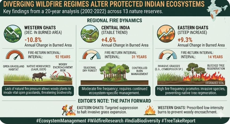
The field data details an escalating crisis in the Eastern Ghats, where the annual burned area rose by 9.3 per cent per annum. In explicit contrast, the Western Ghats exhibited an annual decline in burned area of minus 10.8 per cent, whilst the deciduous landscapes of Central India maintained a stable upward trajectory of 4.6 per cent each year.
The breakdown of fire frequencies
These opposing trajectories directly reflect highly specialised ecological interactions and varying historical intervals. The Western Ghats maintained a prolonged fire-return interval—the average duration between successive blazes in an identical geographic point—of 92 years. Conversely, this fire-return metric collapsed to 31 years in the deciduous tracts of Central India and plummeted to a critical low of just 14 years across the highly vulnerable Eastern Ghats.
"Wildfires are widespread in India, but they feature distinct regional trends and drivers," stated lead investigator Dr Narendran Kodandapani during the release of the spatial maps. He further observed that "integrated fire management that accounts for climate, vegetation, and human factors is important for fire management and policy in Indian ecosystems."
The high-frequency fire cycles across the Eastern Ghats are rapidly driving the proliferation of highly flammable, fire-resistant invasive grasses, specifically from the Cymbopogon genus. This rapid understorey transformation effectively suppresses the natural regeneration cycles of indigenous canopy trees, threatening to permanently modify the botanical identity of the landscape.
The grassland encroachment dilemma
In absolute contrast, the dramatic reduction of historic fire pressures across specific montane zones of the Western Ghats presents an entirely different conservation emergency. The complete absence of controlled fire regimes risks allowing dense, woody shrub layers to aggressively encroach upon open, delicate grassland habitats. These open sub-tropical grasslands are vital foraging grounds for endangered native herbivores, and their gradual shrinkage threatens to destabilise the trophic architecture of the entire southern peninsula.
Statistical modelling within the study shows that anthropogenic activities and local climate variances combined account for anywhere between 21 and 77 per cent of the total annual fire variations observed across the individual wildlife sanctuaries. The researchers noted that while fire has historically been an ecological driver in seasonal tropical forests, the modern divergence demands a total departure from rigid state-level suppression mandates.
Editor's Note
These insights emphasise that India must transition away from centralised, blanket fire-suppression policies and adopt Decentralised Integrated Fire Management (DIFM). Conservation models must actively deploy targeted suppression to halt invasive grass expansion in the Eastern Ghats, while simultaneously utilising carefully managed, prescribed low-intensity burns to prevent woody encroachment upon the fragile, biodiverse grasslands of the Western Ghats.



Leave a comment