

TreeTake Network
August 28, 2026
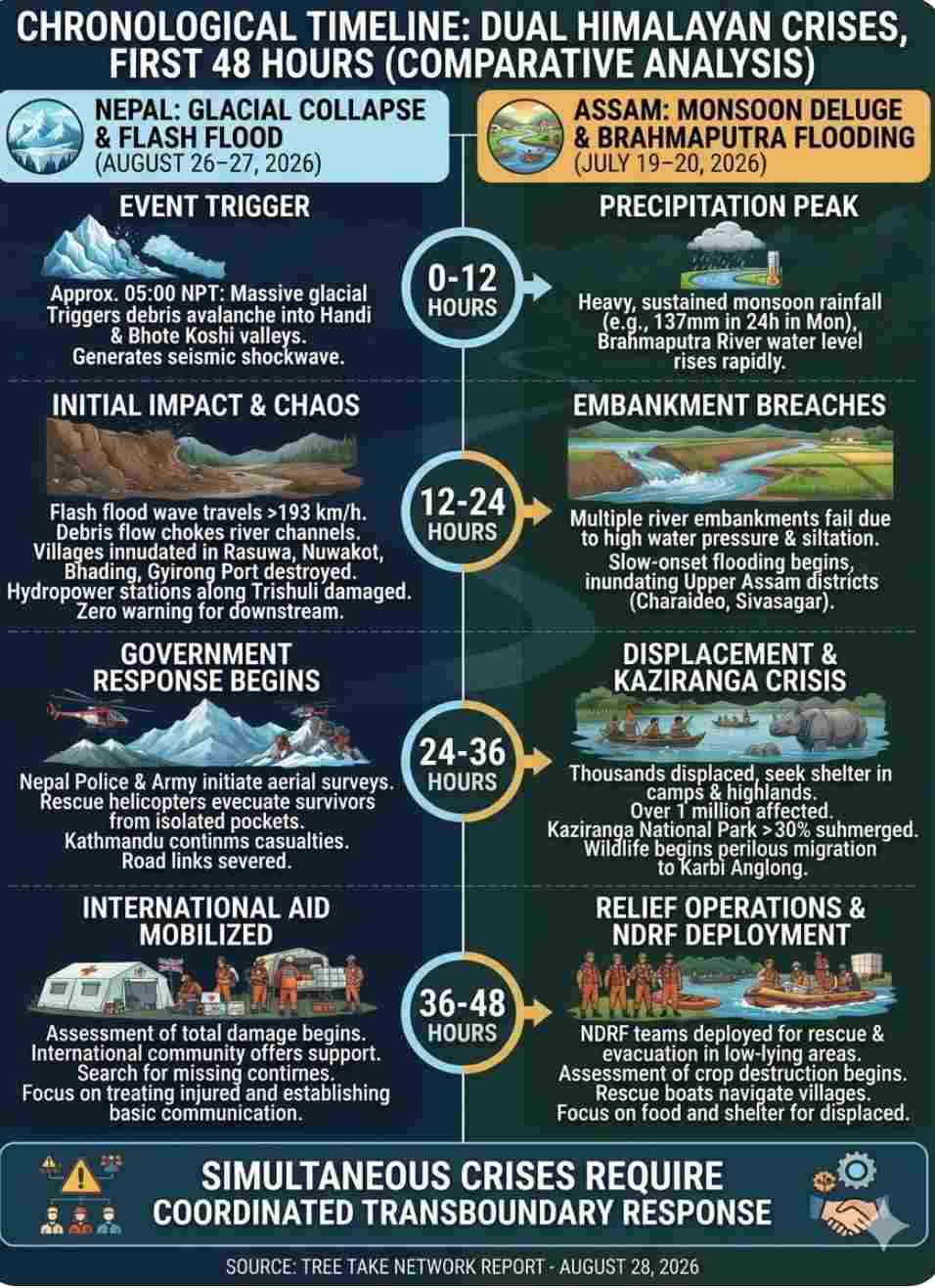
The trans-Himalayan belt and the northeast plains of India are currently grappling with two distinct, climate-accelerated disasters that occurred simultaneously this month. In north-central Nepal, an acute, violent glacial collapse on August 26 triggered a high-velocity "tsunami of dirt" that tore through mountain valleys, leaving hundreds dead and over a thousand missing in a matter of minutes. Concurrently, across the border in Northeast India, the state of Assam is emerging from a month-long, slow-onset monsoon deluge that submerged fifteen districts and displaced over a million people. While Nepal faced a sudden geological shock that maximised casualties, Assam endured a prolonged geographic drowning that hollowed out its agricultural economy. Together, these crises expose the vulnerability of the region to an increasingly unstable water cycle.
The Morning the Mountain Fell: Nepal’s Glacial Collapse
The catastrophe in Nepal began at dawn on Wednesday, August 26, 2026, inside the high-altitude terrain of Langtang National Park. A massive shelf of ice and rock detached from a prominent glacier, cascading down into the narrow valleys below. This high-velocity avalanche choked the upstream channels of the Handi and Bhote Koshi rivers, creating a temporary, highly unstable debris dam. Within minutes, the immense water pressure breached the blockage.
The resulting flash flood travelled down the mountain corridors at speeds averaging 193 kilometres per hour, transforming the river into a dense, destructive slurry of pulverised ice, mud, and boulders. The kinetic force was so immense that local monitoring stations initially registered the impact as a 4.4 magnitude earthquake. The flood wave tore through a 72-kilometre stretch of the Trishuli and Bhote Koshi river systems, striking the districts of Rasuwa, Nuwakot, and Dhading with virtually zero warning, before crossing the international border into Gyirong County in the Tibet Autonomous Region.
The Anatomy of a High-Altitude Failure: The Geological Science
Preliminary data from international monitoring networks indicates that the disaster originated near the Langtang Lirung peak. The primary trigger was a massive glacial collapse rather than a seismic event, though the sheer impact of the falling ice mass hitting the valley floor generated a localised seismic shockwave registering a magnitude of 5.2 on global scales. This type of failure occurs when a section of a glacier or its supporting bedrock disintegrates entirely due to thermal destabilisation.
Geologists point out that global warming has caused the cryosphere—the frozen zones of the planet—to degrade rapidly. In the Hindu Kush Himalaya region, glaciers are currently losing ice at double the rate recorded since 2000. Rising ambient temperatures melt the subsurface permafrost, which acts as the structural glue holding mountain slopes and hanging glaciers together. When this permafrost thaws, the structural integrity of the rock-and-ice interface fails. In the case of the Langtang collapse, the rapid friction during the multi-thousand-foot descent immediately liquefied a high percentage of the pulverised ice. This converted a standard rockfall into a hyper-mobile, fluid debris flow. This water-sediment cascade behaved like a multi-dam break scenario, producing a peak discharge up to ten times greater than typical seasonal high-flow floods.
The Cost of the Flash Flood: Casualties and Broken Infrastructure
The immediate human and economic toll of the Nepal flash flood is catastrophic. As of Friday afternoon, official tallies confirm 392 dead, with 389 casualties in Nepal and 3 in Tibet. Because the wave hit active economic zones, nearly 1,500 people remain missing, buried beneath metres of thick grey silt or washed far downstream. Among the missing are approximately 290 Indian nationals, including religious pilgrims travelling the Kailash Mansarovar circuit and migrant labourers working on riverbank infrastructure.
The structural damage has severely crippled Nepal’s national economy. The Gyirong Port complex, the primary land gateway for trade and tourism between Nepal and China, was destroyed. Furthermore, fourteen run-of-the-river hydropower projects along the Trishuli corridor—both fully operational plants and those nearing completion—sustained severe structural damage, instantly knocking out a major share of Nepal's central electricity grid.
The Slow Drowning of the Brahmaputra Valley
While Nepal was struck by an instantaneous wave, Assam was submerged by a predictable but overwhelming monsoon deluge. Beginning on July 19, 2026, and peaking through early August, Upper Assam recorded exceptional monsoonal rainfall that reached up to 490 per cent above historical averages. Upstream meteorological stations, such as Aboi in the Mon district, logged a staggering 137 millimetres of rain in a single 24-hour window, forcing the massive Brahmaputra River system over its banks.
Unlike the mountain torrents of Nepal, Assam’s crisis is rooted in the unique geography of its plains. The Brahmaputra carries an exceptionally high sediment load from the Himalayas. As the river slows down in the flat Assam Valley, this silt settles onto the riverbed, steadily raising it year after year. This reduced channel capacity, combined with the structural failure of aging earthen embankments, allowed the river to breach its dykes. The flood waters slowly inundated fifteen plains districts, with Charaideo, Sivasagar, Jorhat, Golaghat, Tinsukia, Lakhimpur, and Dhemaji bearing the brunt of the multi-wave deluge.
Displacement and Ecological Ruin: The Kaziranga Migration
The Assam floods resulted in a lower immediate mortality rate than the Nepal disaster, claiming 100 lives by mid-August, but its geographic and socioeconomic footprint is vast. At its peak, the flooding directly affected over one million citizens. More than 168,000 displaced people were forced to abandon their homes and move to temporary, state-run relief camps or elevated highland platforms. More than 45,000 hectares of standing Kharif paddy crops were drowned, destroying the primary livelihood of the valley's agrarian communities.
The crisis extended deeply into Kaziranga National Park, where over 30 percent of the protected sanctuary faced deep inundation. Park authorities note that Kaziranga is a riverine ecosystem that depends on regular annual flooding to deposit nutrients, clear out invasive aquatic weeds, and maintain healthy grasslands. However, the increasing frequency and intensity of modern floods have turned a natural cycle into a survival crisis. Over 116 animals, including several endangered one-horned rhinoceroses and deer, drowned in the high water.
Testimonies from wildlife wardens detail a perilous migration pattern as the park fills with water. Historically, the forests of Karbi Anglong and the grasslands of Kaziranga formed a continuous, uninterrupted wildlife sanctuary. Today, that natural pathway is severed by National Highway 37 and a boom in commercial resorts. As the floodwaters rose, herds of elephants, rhinos, and hog deer were forced to cross this busy highway to seek refuge on the higher ground of the southern hills. This forced migration led to extreme stress, vehicle collisions, and frequent, dangerous encounters with fringe villages where displaced wildlife sought temporary shelter on school verandas and highland farms.
Frontline Defences: The Downstream NDRF Challenge
As the massive volume of water from the Nepalese glacial burst cleared the mountains, it entered the flat plains of northern India, shifting the crisis into a critical transboundary management challenge. The National Disaster Response Force (NDRF) immediately placed its units on high alert, deploying twenty rescue teams—eleven in Uttar Pradesh and nine in Bihar—to secure the vulnerable border districts of West Champaran, East Champaran, Gopalganj, Madhubani, Maharajganj, and Kushinagar.
The NDRF teams face distinct operational challenges in managing this downstream surge. Unlike predictable seasonal floods, the water rushing from the Langtang disaster carries erratic, fluctuating volumes that hit downstream structures like the Valmiki Nagar barrage on the Gandak River with short notice. The primary difficulty stems from a transboundary communication lag. Because the triggering event occurred across the border in Nepal and Tibet, real-time telemetry and upstream gauge readings were initially delayed, forcing Indian commanders to rely on satellite inputs and sudden visual water rises to coordinate evacuations.
Furthermore, the northern plains of Bihar and Uttar Pradesh are among the most densely populated rural regions in the world. The NDRF must manage water discharge while navigating highly fragmented river channels that alter their course overnight due to high silt loads. Moving rescue boats and heavy equipment through rural bottlenecks, where roads are quickly compromised by localized waterlogging, requires precise synchronization with local district magistrates to prevent panic and secure embankment lines before the peak flow arrives.
The Present Situation on the Ground
Today, the two regions face entirely different recovery challenges. In north-central Nepal, multiple mountain villages remain completely isolated, buried under deep layers of hardened mud and boulders. The vital international highway connecting Kathmandu to China is severed at multiple points due to collapsed bridges and massive hillside landslides.
In Assam, the floodwaters of the Brahmaputra, Kopili, and Barak rivers are finally showing a slow, receding trend, but hundreds of low-lying villages remain severely waterlogged. The immediate threat of drowning has passed, replaced by the logistical challenge of clearing thick sand and agricultural silt from roads and fields. The primary focus of local administrations has shifted toward public health, with medical teams working to prevent waterborne disease outbreaks in stagnant pools left behind by the receding river.
Official Stances and the Road Ahead
Official responses highlight the distinct nature of both crises. In Kathmandu, the Ministry of Home Affairs and the Nepal Police confirmed that military helicopters and specialised mountain rescue units have successfully evacuated 796 survivors, including 50 foreign nationals. Geologists and climate scientists have pointed out that the extreme speed of the Nepal wave was accelerated by the immediate melting of pulverised glacial ice during its descent, serving as a stark warning about the rising dangers of high-altitude climate instability.
In Assam, the Assam State Disaster Management Authority (ASDMA) continues to manage relief operations across hundreds of rural revenue circles. Assam Chief Minister Himanta Biswa Sarma has announced a comprehensive digital rehabilitation model to provide direct financial aid. The state is releasing nine lakh rupees to the next of kin for every confirmed casualty, alongside an emergency allowance of 15,000 rupees for each severely impacted family, verified through door-to-door digital damage assessments.
Ultimately, the dual crises of August 2026 demonstrate that whether water arrives as an instantaneous wall of mountain mud or a slow, relentless rise in the plains, the trans-Himalayan ecosystem requires unified, transboundary early-warning systems to protect lives before the water begins to move.



Leave a comment