

Tree Take Network
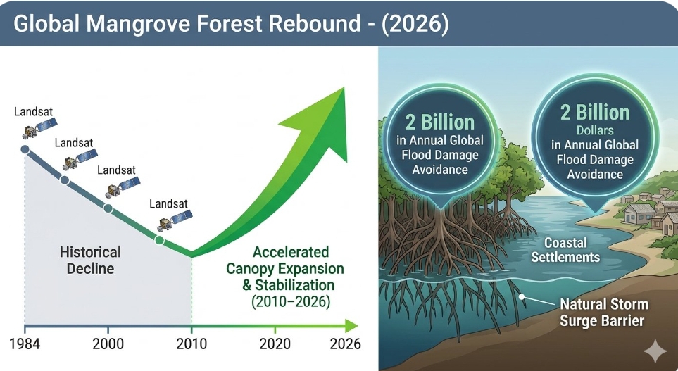
A comprehensive multi-decade scientific data analysis released by NASA's Earth Observatory on 13 November 2026 has revealed a definitive, unexpected reversal in the decline of the world's mangrove forests. Utilising continuous satellite mapping from the Landsat 5 through Landsat 9 missions spanning from 1984 to 2023, international researchers have documented a distinct transition from historical net loss to accelerated expansion and natural propagation. The data show that the global mangrove canopy footprint began a structural stabilisation in 2010, with subsequent growth in the past decade nearly offsetting the severe structural losses previously driven by aquaculture, logging, and urban conversion.
The peer-reviewed findings, originally supported by historical baseline mapping led by the U.S. Geological Survey, emphasise that modern conservation models have shifted the ecological trajectory of these critical coastal buffer zones. By examining more than 1,100 individual satellite scenes across 118 countries, the global monitoring platforms have identified substantial localised gains clustered along river deltas and sediment-rich tropical coastlines.
"What we are observing through the Landsat record is an extraordinary testament to targeted conservation success and natural resilience," stated Dr Peter Lecomte, a senior carbon-cycle analyst at the NASA Goddard Space Flight Centre. "For nearly 30 years, our data models mapped nothing but systematic fragmentation and coastal degradation. The structural pivot toward net gains over the last decade proves that localised preservation policies and the natural colonisation of sediment deposits are actively reshaping the biosphere to favour maritime climate adaptation."
Dynamic sediment accumulation drives natural expansion across global hotspots
The satellite analysis demonstrates that 65% of the newly recorded mangrove gains are occurring on fresh sediment beds formed by coastal and inland erosion. While these dynamic mudflats do not directly replace the intricate biodiversity profiles of lost old-growth estuarine systems, they provide critical new real estate for rapid mangrove propagation. The expansion has manifested with particular velocity across northern Australia, portions of South Asia, the Middle East, and distinct coastal corridors within the Americas.
According to the data models, the increased density and persistence of these rebounding canopies have significantly enhanced coastal blue carbon storage capacities. Marine ecologists tracking the satellite imagery noted that healthy mangrove systems provide roughly 2 billion dollars in annual global flood damage avoidance, serving as natural structural seawalls that protect approximately half a million vulnerable coastal residents from intensifying storm surges.
"The capability to monitor these transformations back to 1985 allows us to identify exactly where restoration models are succeeding," observed Lola Fatoyinbo, a lead research scientist at the Global Mangrove Watch platform. "The gradual slowing of losses over 40 years followed by this definitive expansion proves that nature can reclaim lost territory when human pressures are managed. However, the data also reveals that severe vulnerabilities persist, particularly within West and Central Africa, where urban conversion and oil pollution continue to challenge the global trend."
Balancing recovery against the escalating threat of rising sea levels
Despite the accelerating canopy recovery, the NASA report cautions that long-term mangrove survival remains tied to complex global hydrological changes. Ongoing marine research warns that while conservation efforts are successfully combating direct human clearing, rapid sea-level rise threatens to drown lower-lying seaward boundaries if localised sediment accumulation rates fail to keep pace with the changing tides.
The global findings are being integrated into the framework of the Global Mangrove Alliance, which has established definitive targets for 2030, including doubling the legally protected status of global mangrove areas from the historical baseline of 6.9% to a minimum of 30%. The alliance plans to utilise the high-resolution Landsat datasets to direct funding toward the restoration of recently degraded estuaries.
"The satellite record shows the tide is turning, but we cannot afford complacency," remarked structured conservation director Mark Spalding of The Nature Conservancy. "Mangroves sit at the absolute centre of the climate crisis—protecting fisheries, storing immense quantities of soil carbon, and defending human infrastructure. We must utilise this verified satellite data to guide national climate adaptation strategies, ensuring that our protection mechanisms expand faster than the rising oceans can alter these vital coastal sanctuaries."
Editor's Note
The verified global mangrove rebound detailed by NASA on 13 November 2026 offers a rare, data-grounded example of environmental recovery in an era dominated by ecological decline. By demonstrating that targeted habitat protection can completely reverse multi-decade loss trends, this satellite study validates the financial and social capital invested in coastal conservation. Moving forward, the international community must transition from localised restoration projects to systematic, cross-border legal protections that insulate these expanding intertidal forests from future commercial infrastructure development and marine pollution.


.jpg?resize=120%2C90&ssl=1)



Leave a comment