

TreeTake Network
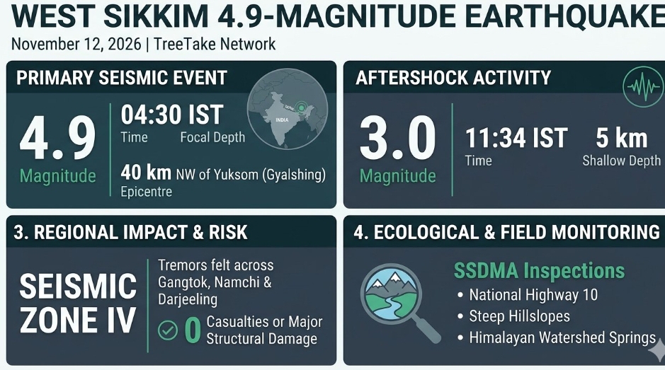
A moderate earthquake measuring 4.9 on the Richter scale struck the West Sikkim border region during the early hours of November 12, 2026, sending distinct tremors across Gangtok, Gyalshing, Namchi, and neighbouring hill districts of northern West Bengal. According to official parameters recorded by the National Centre for Seismology (NCS), the primary tremor occurred at 04:30 hours IST at a focal depth of 73 kilometres, with its epicentre located at 27.63 degrees North latitude and 87.98 degrees East longitude, approximately 40 kilometres northwest of Yuksom in Gyalshing district.
Seismic Parameters and Aftershock Activity
Seismological stations across the eastern Himalayan belt registered a subsequent 3.0-magnitude aftershock in the same source zone at 11:34 hours IST on November 12, 2026, occurring at a shallow focal depth of five kilometres. While the pre-dawn tremor awakened residents across high-altitude settlements and prompted brief evacuations into open areas, district disaster management authorities confirmed zero casualties and zero major structural damage across Sikkim and northern West Bengal.
"The earthquake occurred at an intermediate depth of 73 kilometres along the active eastern Himalayan tectonic belt, which helps dissipate surface ground shaking compared to very shallow crustal events," explained Dr O P Mishra, Director of the National Centre for Seismology. "Our regional seismic network continuously monitors aftershock sequences across Sikkim and adjoining Himalayan zones to provide real-time updates to state disaster response authorities."
Regional Tectonic Vulnerability and Ecological Monitoring
Situated within Seismic Zone IV—a high-damage-risk zone under India's seismic zoning classification—the Sikkim Himalaya experiences recurrent tectonic stress resulting from the ongoing northward convergence of the Indian plate beneath the Eurasian plate. Beyond built infrastructure, geologists and mountain ecologists emphasise that moderate seismic events in steep, moisture-saturated Himalayan catchments can destabilise fragile slopes, trigger delayed rockfalls, and disrupt high-altitude watershed springs.
"Even moderate earthquakes in the eastern Himalaya require close post-event monitoring of steep hillslopes, glacial moraines, and river gorges," noted Dr Kalachand Sain, Director of the Wadia Institute of Himalayan Geology. "Ground shaking can weaken fractured rock masses and alter subsurface groundwater pathways, making continuous geological surveillance essential for protecting mountain ecosystems and downstream communities."
District Emergency Preparedness and Field Verification
Following the 04:30 hours IST tremor on November 12, 2026, the Sikkim State Disaster Management Authority (SSDMA) activated district emergency operations centres in Gyalshing, Gangtok, Mangan, and Soreng to conduct rapid visual inspections of bridges, hydroelectric installations, and forest-fringe settlements. Field teams reported normal operational status across key road corridors, including National Highway 10, while advising residents in landslide-prone pockets to report any fresh ground cracks or sudden changes in spring water turbidity.
"All district control rooms and block-level response teams were immediately placed on alert following the pre-dawn tremor, and preliminary field assessments confirm that no loss of life or major property damage has occurred," stated Prabhakar Rai, Director of the Sikkim State Disaster Management Authority. "We urge citizens to remain calm, follow official seismic safety protocols, and avoid circulating unverified rumours on social media."
Editor's Note
The November 12, 2026 earthquake in West Sikkim serves as a timely reminder of the persistent seismic vulnerability across the eastern Himalayan biodiversity hotspot. While the intermediate focal depth of 73 kilometres mitigated severe surface destruction, cumulative tectonic stress combined with extreme weather patterns demands rigorous enforcement of seismic-resilient building codes and slope-stabilisation measures. Strengthening community-level disaster preparedness alongside continuous geological monitoring of fragile watersheds remains vital to safeguarding both human settlements and mountain ecosystems.

.jpg?resize=780%2C450&ssl=1)


.jpg?resize=120%2C90&ssl=1)



Leave a comment