

TreeTake Network
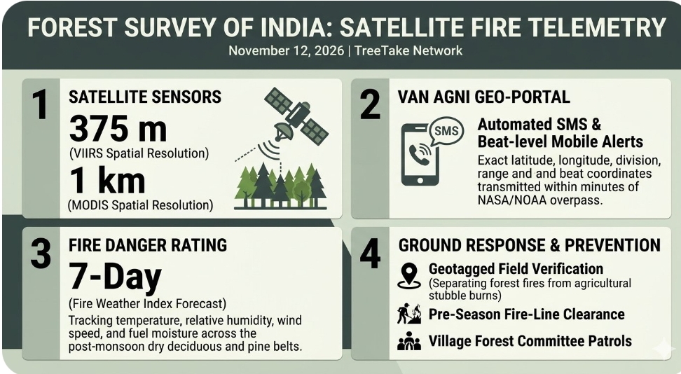
The Forest Survey of India (FSI) disseminated automated near-real-time satellite forest fire alerts across state forest departments on November 12, 2026, utilising high-resolution thermal anomaly detections from the Visible Infrared Imaging Radiometer Suite (VIIRS) and Moderate Resolution Imaging Spectroradiometer (MODIS) sensors to trigger rapid field verification and ground suppression protocols. Integrated through the FSI Van Agni Geo-portal and early-warning SMS alerting architecture, the November 12, 2026 detections enable beat-level forest officials to pinpoint active thermal hotspots inside notified forest boundaries during the critical post-monsoon dry transition.
Satellite Telemetry and Automated Geo-Portal Dissemination
Operating from its Dehradun headquarters under the Union Ministry of Environment, Forest and Climate Change, the Forest Survey of India processes multiple daily orbital passes from NASA and NOAA polar-orbiting satellites to detect thermal anomalies at 375-metre spatial resolution via VIIRS and one-kilometre resolution via MODIS. Once thermal coordinates are filtered against India's digitised forest cover boundary layer, automated alerts containing exact latitude, longitude, forest division, range, and beat metadata are transmitted directly to registered state nodal officers and frontline forest guards within minutes of satellite overpass.
"Near-real-time satellite fire alerts from VIIRS and MODIS sensors allow state forest departments to detect surface fires in their nascent stage before dry leaf litter accumulation fuels large-scale crown fires," explained Dr Anoop Singh, Director General of the Forest Survey of India. "By linking space-based thermal detection directly with beat-level mobile reporting on the Van Agni Geo-portal, frontline personnel can initiate rapid containment and track burn-scar recovery accurately."
Post-Monsoon Biomass Dryness and Regional Fire Vulnerability
Forest ecologists and fire-management specialists noted on November 12, 2026, that the transition from post-monsoon moisture to dry November conditions across central, eastern, and northern Indian forest landscapes accelerates the curing of undergrowth grasses and fallen deciduous litter. In addition to natural dryness, agricultural residue burning along forest-fringe revenue lands frequently triggers false thermal alarms or escapes across unmaintained fire lines into reserve forests, requiring immediate ground truthing by range teams.
"Early winter dryness across deciduous and pine-dominated forest belts creates substantial surface fuel loads that can ignite rapidly from unattended agricultural burns or human negligence," warned Dr R K Singh, senior forest fire management specialist at the Indian Council of Forestry Research and Education (ICFRE) in Dehradun. "Combining satellite thermal alerts with pre-season fire-line clearance and community-based joint forest management patrols remains essential to safeguarding regeneration and soil biodiversity."
State-Level Field Verification and Fire Danger Rating Protocols
Alongside active hotspot alerts, the Forest Survey of India's seven-day Fire Weather Index-based Forest Fire Danger Rating System continues to map meteorological fire risk across forest divisions nationwide by integrating surface temperature, relative humidity, wind speed, and fuel moisture parameters. State forest control rooms use these daily danger maps to pre-position fire watchers, water tankers, and leaf blowers in high-risk ranges while verifying every incoming satellite coordinate through geotagged field feedback.
"Timely field verification of every satellite alert helps distinguish genuine forest floor fires from adjacent agricultural stubble burns, ensuring that suppression resources are deployed where ecological damage is greatest," stated Subhash Chandra, former Additional Director General of Forests (Wildlife) in the Union Ministry of Environment, Forest and Climate Change. "Strengthening coordination between state forest departments and local village forest committees converts early satellite detection into effective on-ground prevention."
Editor's Note
The dissemination of near-real-time VIIRS and MODIS forest fire alerts by the Forest Survey of India on November 12, 2026, highlights the vital role of space-based environmental telemetry in protecting India's forest ecosystems during seasonal dry transitions. While automated satellite alerts dramatically compress detection time, technology alone cannot substitute for physical fire-line maintenance and community stewardship along forest fringes. Moving forward, integrating real-time satellite tracking with incentivised village-level fire prevention programmes and sustainable biomass management will be decisive in reducing recurring forest fire losses across India.


.jpg?resize=120%2C90&ssl=1)



Leave a comment