

Talking Point
TreeTake Network
The India Meteorological Department (IMD) issued a multi-region severe weather advisory in its afternoon national bulletin at 13:20 hours IST on November 12, 2026, warning of isolated heavy rainfall, hailstorms, and squally winds across the Western Himalayan Region alongside an emerging cyclonic low-pressure system over the Southeast Bay of Bengal. Driven simultaneously by an active Western Disturbance over Kashmir division and a lower-to-middle tropospheric cyclonic circulation over the central Andaman Sea, the dual weather systems are forecast to bring widespread precipitation, rough maritime conditions, and heightened landslide and crop-damage risks through mid-November.
Western Disturbance Triggers Orange Alert and Hailstorm Warnings in Kashmir and Ladakh
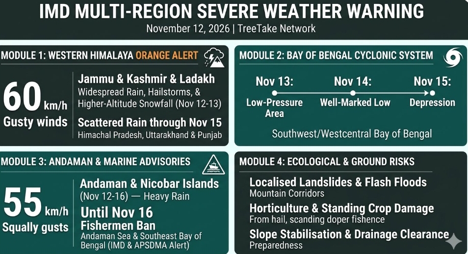
An active Western Disturbance positioned as a cyclonic circulation over Kashmir division and its neighbourhood in lower tropospheric levels—supported by a middle-tropospheric trough running along 72 degrees East longitude to the north of 32 degrees North latitude—prompted the IMD to issue an orange colour warning for Jammu and Kashmir on November 12, 2026. Fairly widespread to widespread rainfall and higher-altitude snowfall are forecast across Jammu-Kashmir-Ladakh-Gilgit-Baltistan-Muzaffarabad on November 12 and November 13, 2026, accompanied by isolated heavy rainfall, hailstorms, lightning, and gusty winds reaching 40 to 50 kilometres per hour and gusting up to 60 kilometres per hour. Adjacent hill states including Himachal Pradesh and Uttarakhand, along with parts of Punjab, are also expected to experience isolated to scattered rainfall, thunderstorms, and lightning between November 12 and November 15, 2026.
"The upper-air cyclonic circulation over Kashmir division is interacting with strong moisture incursion from the Arabian Sea, resulting in intense convective activity, hailstorms, and snowfall over higher reaches of Jammu and Kashmir and Ladakh," stated Dr Mrutyunjay Mohapatra, Director General of Meteorology at the India Meteorological Department. "District administrations across vulnerable mountain corridors have been advised to monitor steep slopes closely for localised landslides and flash floods."
"Horticulture orchards, standing crops, and unreinforced structures face elevated risk from hailstorms and squally gusts reaching 60 kilometres per hour," added Dr Mukhtar Ahmad, Director of the Meteorological Centre in Srinagar. "Travellers along the Srinagar-Jammu National Highway and high-altitude passes should verify road clearance advisories before undertaking journeys."
Bay of Bengal Cyclonic Circulation Threatens Andaman and Nicobar Islands
Concurrently, an upper-air cyclonic circulation over the central Andaman Sea and adjoining south Andaman Sea on November 12, 2026, is forecast to induce a low-pressure area over the Southeast Bay of Bengal around November 13, 2026. Meteorological models indicate that the system will move west-northwestwards, concentrating into a well-marked low-pressure area by November 14, 2026, and further intensifying into a depression over the Southwest and adjoining Westcentral Bay of Bengal around November 15, 2026. Consequently, fairly widespread to widespread rainfall with isolated heavy falls and squally winds reaching 35 to 45 kilometres per hour, gusting to 55 kilometres per hour, are forecast over the Andaman and Nicobar Islands between November 12 and November 16, 2026.
"Sea conditions are expected to become rough to very rough over the Andaman Sea and adjoining Southeast Bay of Bengal from November 13 onwards as the low-pressure system organises," explained Dr Ananda Kumar Das, senior scientist and head of the Cyclone Warning Division at the India Meteorological Department. "Fishermen are strictly advised not to venture into the Andaman Sea and Southeast Bay of Bengal until November 16, and vessels already at sea should return to harbour immediately."
"Rough sea conditions are expected from Saturday through Tuesday, and fishermen are advised not to venture into the sea until November 16," confirmed Prakhar Jain, Managing Director of the Andhra Pradesh State Disaster Management Authority, following regional coastal preparedness reviews.
Ecological Vulnerability and Community Safety Measures
Beyond immediate maritime and aviation disruptions, meteorologists and environmental planners emphasised that intense November hailstorms and unseasonal heavy rainfall heighten soil erosion across fragile Himalayan watersheds while accelerating coastal wave erosion across low-lying island ecosystems in the Andaman archipelago. Authorities across both regions have urged residents to avoid sheltering under isolated trees during thunderstorms, secure loose agricultural and maritime equipment, and maintain clear drainage channels in low-lying urban pockets.
"Integrating real-time Doppler weather radar observations with district-level early warning dissemination enables local authorities to pre-position disaster response teams before severe weather peaks," noted Prof K J Ramesh, former Director General of Meteorology at the India Meteorological Department. "Timely compliance with official agrometeorological and marine advisories remains the most effective safeguard against preventable loss of life and livelihood."
Editor's Note
The simultaneous activation of an intense Western Disturbance over the Western Himalaya and a developing cyclonic low-pressure system over the Bay of Bengal on November 12, 2026, illustrates the complex atmospheric transitions characteristic of India's post-monsoon season. While advance orange-level alerts and marine warnings provide vital lead time for mountain districts and coastal authorities, recurring extreme precipitation events highlight the urgency of slope stabilisation, resilient urban drainage, and climate-adaptive agricultural protection. Moving forward, sustained coordination between national meteorological centres and grassroots disaster management units will remain essential to mitigating weather-induced ecological and economic losses.


.jpg?resize=120%2C90&ssl=1)



Leave a comment