

TreeTake Network
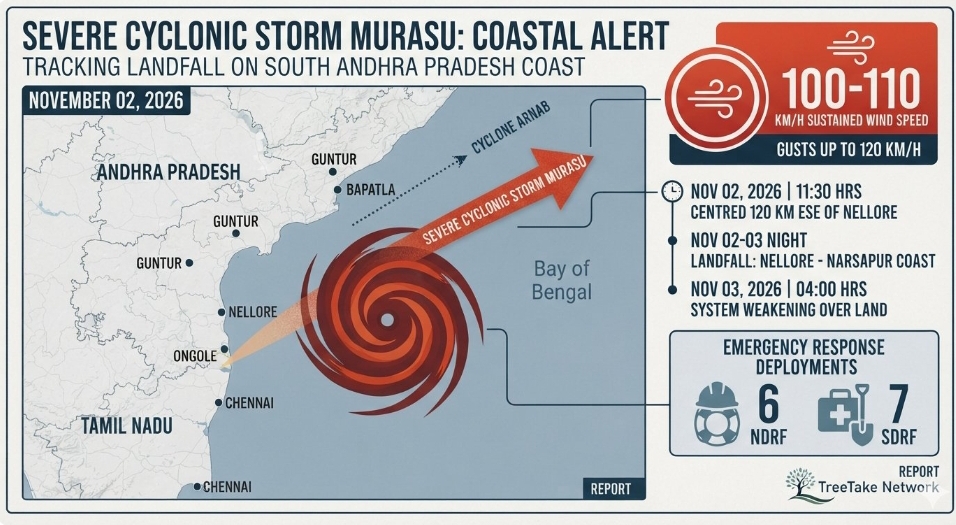
The India Meteorological Department issued a red category storm warning today as Severe Cyclonic Storm Murasu intensified dramatically over the West Central Bay of Bengal. Moving at a speed of 14 km/h, the atmospheric system lay centred roughly 120 km east-southeast of Nellore and 180 km southeast of Ongole at 1130 hours today. Current structural projections indicate that the severe storm system is highly likely to cross the south Andhra Pradesh coast between Nellore and Narsapur, just south of Ongole, between 2330 hours tonight, November 02, 2026, and 0400 hours tomorrow morning, November 03, 2026.
The impending disaster follows less than a week after Cyclone Arnab battered the same agricultural coastline, severely complicating ongoing response mechanics. Meteorological trackers confirm that Murasu will make landfall packing sustained wind speeds of 100 to 110 km/h, with destructive gusts reaching up to 120 km/h. Regional administrations have ordered the comprehensive closure of academic institutions across vulnerable coastal districts, whilst heavy precipitation alerts have simultaneously extended into adjoining jurisdictions within Tamil Nadu, Telangana and Odisha.
Massive Storm Surge and Evacuations Engaged
The apex weather agency has paired its tracking layout with a severe storm surge warning. Tidal walls standing between 1.0 and 1.5 metres above regular astronomical levels are anticipated to temporarily inundate low-lying agricultural zones and fishing settlements during the hours of landfall. The worst impacts of this environmental displacement are projected to manifest heavily across the Bapatla, Krishna and Prakasam districts.
In response, the Andhra Pradesh State Disaster Management Authority has enacted large-scale evacuation protocols. Exactly 6 highly specialised teams from the National Disaster Response Force alongside 7 teams from the State Disaster Response Force have been distributed across high-risk locations. Exactly 2 strategic containment groups each have taken up static monitoring positions within Krishna, Bapatla, Guntur, Nellore and Prakasam, whilst additional singular units are actively fortifying lines in Markapuram, Palnadu and Tirupati.
Administrative Preparedness and Expert Voices
Reviewing the operational deployment from the state's command centre, Chief Minister N Chandrababu Naidu confirmed that structural relief materials have been mobilised to minimise communication and logistical failures. State engineers have already prepositioned massive resource reserves to protect local grids. Following the absolute destruction of structural utility networks by the previous storm, 31000 electricity poles had been distributed across fields, and administrators calculate that an additional 8000 poles could experience direct vulnerability under Murasu's imminent impact. To mitigate prolonged blackout windows, an extra team of 1000 grid personnel is being brought directly from Chennai to assist local networks in Nellore and Prakasam.
"We have instructed all district collectors and maritime monitoring bodies to enforce an absolute ban on fishing activities across the West Central Bay of Bengal," stated Chief Minister Naidu during an emergency briefing at the Real Time Governance Society facility in Amaravati. "Whilst the overall physical footprint of Murasu may indicate lower absolute wind velocity thresholds than its predecessor Arnab, our administrative focus remains explicitly fixed on ensuring zero loss of human life. We are directing local irrigation frameworks to carefully redirect the heavy precipitation runoff into regional reservoirs to counteract long-term agricultural drought risks without endangering vulnerable settlements."
In an official public notification broadcast by the Regional Meteorological Centre in Chennai, Director S Balachandran contextualised the severe pattern: "The storm's title, Murasu, represents an ancient Tamil percussion instrument traditionally utilised by ancient societies to disseminate urgent alerts and broadcast danger signals to local populations. Given that Doppler weather radars at Chennai, Machilipatnam and Visakhapatnam are registering highly energised convective bands, the coastal populace must strictly adhere to state protocols and remain indoors until the core system fully dissipates over land."
Adding to the meteorological perspective, Dr Mrutyunjay Mohapatra, Director General of Meteorology at the India Meteorological Department, emphasised the complex nature of this multi-storm scenario: "The coastal infrastructure in Andhra Pradesh is currently experiencing extreme structural stress due to the saturated soil conditions left behind by Cyclone Arnab. Murasu is operating on a highly organised convective core, which means the principal danger is no longer just the heavy wind velocity, but the prolonged rain, which will total over 200 mm within 24 hours in isolated pockets, triggering severe localised flash floods."
Editor's Note
The rapid succession of Cyclones Arnab and Murasu within a single week underscores an alarming acceleration of tropical cyclogenesis in the North Indian Ocean, driven primarily by elevated sea-surface thermal anomalies that favour more intense systems. As climate-induced disruptions increase the baseline volatility of the Bay of Bengal, traditional disaster response protocols must transition from a reactive posture into structural resilience frameworks. The immediate priority remains the total safety of human lives through precision evacuations, yet the long-term ecological trajectory demands rapid structural upgrades to coastal embankments, climate-resilient power infrastructure, and advanced hydrological management to absorb multi-storm impacts safely.



Leave a comment