

TreeTake Network
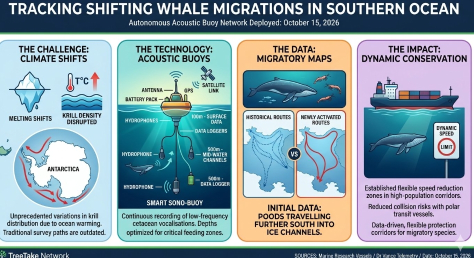
Marine research vessels operating in the Antarctic sector on October 15, 2026, successfully completed the deployment of a advanced network of autonomous acoustic buoys designed to map shifting blue whale feeding routes. The remote tracking infrastructure responds to unprecedented variations in regional krill distributions caused by elevated sea surface temperatures across the Southern Ocean.
The deep-water listening stations record low-frequency cetacean vocalisations continuously, sending real-time location and density metrics via satellite networks to international tracking databases. "Traditional survey paths no longer align with where these marine mammals are actually congregating to feed," noted Dr Eleanor Vance, a lead marine bioacoustician tracking Antarctic ecosystems. "By monitoring these waters continuously through passive acoustics, we can dynamically trace their adapted movements as climate pressures alter the baseline of the polar food web."
Initial data returns from the newly active perimeter reveal that whale pods are travelling significantly further south into deeper icy channels than historically documented. Oceanographers indicate that these behavioural adjustments expose migratory pods to unpredictable sea-ice dynamics and increased collision risks with commercial polar transit vessels operating outside established seasonal shipping lanes.
The collected telemetry will be shared across international maritime channels to establish dynamic, flexible speed reduction zones in highly populated whale feeding corridors. Marine protection coalitions emphasise that adapting conservation boundaries to match real-time animal locations remains the most effective structural path to safeguard vulnerable marine populations from intensifying industrial maritime traffic.
Editor's Note: The integration of autonomous acoustic networks marks a critical evolution towards data-driven, dynamic marine sanctuary management. To protect highly migratory species effectively under rapid climate shifts, international maritime authorities must transition from rigid geographic boundaries to flexible, real-time protection corridors that adapt to animal movements.



Leave a comment