

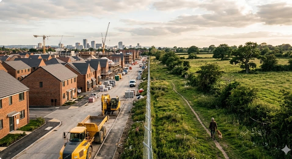
TreeTake explores the dangerous ecological destruction occurring right on our city doorsteps, where village community lands like Gauchar and Shamlat are being silently wiped out by rapid industrial and logistics expansion. Focusing on the rapidly changing Lucknow-Kanpur Industrial Corridor, this investigative cover story reveals how paving over these vital transitional zones creates a destructive ring of heat around our cities, triggers toxic groundwater pollution through illegal dumping and causes severe seasonal flash floods by destroying natural water catchments. Through authentic insights from regional field scientists, hydrologists, and anthropologists, we expose a massive environmental policy gap that leaves peri-urban communities unmonitored and unprotected, ultimately presenting a powerful call to action for digital mapping, native re-wilding, and a new philosophy of community guardianship to secure our shared survival…
India's peri-urban commons are undergoing rapid ecological degradation driven by urbanisation, waste dumping and industrial encroachment, threatening local biodiversity and livelihoods. This transformation converts vital ecological buffers into degraded landscapes, necessitating immediate conservation efforts.
The invisible boundaries where concrete cities meet rural greenery are undergoing an ecological collapse. While mainstream headlines rightly dissect metropolitan toxic smog and Himalayan forest fires, a massive environmental blind spot is growing right on our city doorsteps. The rapid, unchecked degradation of peri-urban common lands—the transitional zones where municipal limits blur into the countryside—is altering our landscape forever. For generations, village common lands have served as the silent life-support systems of rural ecosystems. They are the grazing fields for livestock, the natural catchment basins for local monsoons and a refuge for indigenous biodiversity. Today, these critical buffer zones are being silently carved up for logistics parks, unregulated construction dumps and commercial sprawl. This is an investigation into a major environmental tragedy occurring in the shadows of our fastest-growing cities. It is a crisis that poses an immediate threat to the air we breathe, the water we drink, and the long-term survival of both rural and urban communities. "Encroachments over commons have become widespread over the last few decades, driven by urbanisation, soaring land values and increasing population pressures. The demand for land has led to the conversion of commons into private or commercial spaces," said Saurabh Thakur and Dr Hitaishi Vashistha, in an analytical piece on India's institutional gaps for "Ideas for India".
The illusion of the empty fringe
Drive along the multi-lane highway corridors extending outward from Lucknow towards Kanpur or trace the geometric precision of the National Capital Region (NCR) expressway arteries. The view out of the window tells a seductive story of modern Indian advancement. You will see towering apartment complexes draped in glass, sprawling logistics warehouses and newly manicured industrial parks. This is India’s peri-urban frontier. However, if you step off the asphalt and walk past the high concrete boundary walls, a radically different and far more alarming reality exposes itself. Behind the shiny facades of rapid urbanisation lies the systematic, silent annihilation of India’s traditional village common lands. Known across various regions of India as Gauchar (grazing lands), Shamlat (community-owned land), or Poramboke (uncultivated public tracts), these areas have functioned for hundreds of years as shared resources. They have never been mere space waiting to be paved over; they are functional, living ecological shields. As these lands sit completely outside the strict regulatory jurisdiction of city municipal corporations and lack the organised protections given to rural agricultural lands, they have fallen into a governance black hole.
Scholars monitoring spatial resource distribution have repeatedly raised warnings about this blind spot. In studies analysing how urbanisation actively reshapes community resources, research teams at institutions like the Centre for Urban Ecological Sustainability have highlighted that rapid urban expansion consistently favours the immediate commercial needs of the core city by systematically depriving peri-urban areas of their traditional common resources, resulting in intense resource conflicts and localised marginalisation. By ignoring the peri-urban commons, regional master plans tear down the very biological shock absorbers that protect expanding urban landscapes from severe climate and environmental extremes. Once a village common is entirely paved over, standard engineering projects cannot simply recreate the complex natural buffer systems that were lost. 2:24 AM (2 hours ago). Dr Vishwa Ballabh, in his research paper "Where have all the commons gone?” rightly said, “The commons have increasingly come to bear the ecological footprint of urbanisation as they got acquired or encroached upon for urban expansion and required infrastructure. This compromises the livelihood security of those who depend on them for sustenance."
Micro-climate shift and the ring of heat
The loss of native vegetation on the city's outskirts alters the local weather in ways that scientists are only beginning to fully map. When thick groves of indigenous trees like Banyan, Neem and Peepal are cleared to make room for industrial developments, a massive natural cooling system is permanently turned off. These native trees play an essential role in regulating regional temperatures through transpiration. When they are replaced by vast expanses of dark asphalt roofs, concrete yards and corrugated iron sheds, the peri-urban belt begins absorbing and storing massive amounts of solar radiation. The result is a literal ring of high heat that traps pollution and warm air directly over the entire metropolitan region, intensifying summer heatwaves. Prominent environmental policy experts have frequently pointed out that the climate crisis in India is not a distant future threat but a present reality manifested in altered local micro-climates. Academic research tracking urbanisation-driven land degradation confirms that this rapid alteration directly increases localised urban heating and micro-climate vulnerability. The peri-urban commons used to act as an ecological cooling engine for the concrete cores of our cities. Today, those fringes are heat intensifiers. When you destroy native tree canopies on the edge of a growing city to build an unshaded warehouse park, you are directly raising the local surface temperature. Multiply that across every fringe expansion road, and the macro-level results become catastrophic for public health.
Case in point: Lucknow-Kanpur industrial corridor
To observe the real-time breakdown of this vital landscape, one needs to travel no further than the expanding industrial corridor connecting Lucknow and Kanpur. This segment of the National Highway landscape serves as a stark textbook example of peri-urban degradation. Over the last decade, the villages flanking Unnao, Amausi and Piparsand have transformed from agrarian buffer zones into a dense, unmapped web of private logistics yards, leather processing facilities, and massive warehousing units. In this specific corridor, the loss of the village talaabs (ponds) and community pasture lands has completely altered the local environment. Historically, this region sat within the central plains of the Indo-Gangetic basin, packed with seasonal wetlands that absorbed monsoon run-off from nearby fields. Today, the natural drainage lines are completely blocked by high concrete embankments built by private construction projects. The administrative push to build up this zone has inadvertently outpaced local infrastructure safety nets.
While state bodies like the Uttar Pradesh Expressways Industrial Development Authority (UPEIDA) have recognised the strain and recently initiated steps to establish specialised laboratories to monitor air quality, noise, groundwater quality, and soil quality specifically across the industrial corridors of Lucknow and Kanpur, the historical damage to the unclassified commons remains severe. Environmental assessments across the fringe corridor show that as village commons are filled with industrial waste and construction debris, the regional water cycle fractures. When a standard monsoon rain hits the Lucknow-Kanpur highway, the water no longer moves naturally toward the central aquifers. It pools on the asphalt, causes immense traffic gridlocks, and floods the lower-income housing colonies built right on the fringes. Furthermore, because these transitional pockets operate just beyond the daily watch of central municipal pollution control boards, untreated toxic waste is frequently discharged directly onto what remains of the public grazing lands. This rapid, unstructured expansion along the corridor has created severe industrial friction with the local agrarian economy. Shallow borewells used by the local villagers are reporting rising chemical strain, yet the urban consumer in the city centre eats the vegetables grown in these very same peri-urban fields, completely unaware that the food chain is being impacted right at the city gates.
Ghost waste crisis and unseen toxicity
As peri-urban areas sit in a governance blind spot, they lack the organised waste collection infrastructure found in major cities. Yet, they have become the primary destination for the waste generated by those very same cities. Every single night, fleets of uncovered trucks slip past city borders to dump thousands of tonnes of construction rubble, unsorted plastic debris and toxic electronic waste directly onto village common lands. This unregulated dumping ruins local beauty and leaks hazardous heavy metals into the ecosystem.
This phenomenon is what experts call the ghost waste crisis—a stream of refuse that officially does not exist because it falls outside municipal tracking systems. Well-known urban ecologists, such as Professor Harini Nagendra, have long noted that while the word "commons" usually evokes imagery of a distant rural landscape with ponds and grazing lands, these spaces are equally essential for the survival of expanding urban zones, yet they remain almost entirely ignored in formal urban policy and planning. The city purifies its inner core by pushing its toxicity to its edges. Municipal corporations frequently boast about clean city rankings and beautiful green spaces, but if you trace where the actual waste from those massive urban redevelopment projects is going, it leads straight to the low-lying common lands of fringe villages. This creates an unequal transfer of pollution from affluent urban centres to vulnerable rural landscapes, and because there are no permanent environmental air or soil monitoring stations out there, it goes largely unpunished.
Vanishing water catchments and the paradox of floods
Historically, village common lands were intentionally centred around natural topographical depressions. These areas featured networks of community ponds and natural seasonal drainage channels designed to catch monsoon rains. They served as vital water catchments that refilled regional underground water tables while keeping low-lying areas from flooding. When real estate projects fill these natural basins with concrete, the water has nowhere to go. This creates a dangerous paradox: during the summer months, local communities face severe water shortages as groundwater tables drop rapidly; during the monsoon season, the very same areas suffer from sudden, destructive flash floods because the natural drainage pathways have been entirely blocked.
Environmental researchers focusing on peri-urban water security across India explicitly warn about these long-term risks. Policy briefs tracking water governance in transitional areas note that continuous land conversion severely damages wetlands, recharge zones and community ponds. This rapid construction reduces natural drainage systems to a point where heavy rainfall immediately leads to severe flash floods while simultaneously causing a drastic, long-term decline in vital groundwater recharge. You cannot replace a vast, natural aquifer recharge zone with a standard rainwater harvesting pipe on a commercial building and expect the same ecological results. The peri-urban commons were massive, sponge-like systems. They absorbed the shock of heavy monsoon downpours and slowly fed the groundwater over the next nine months. By paving over these catchments, we ensure that our cities flood every time it rains heavily, and our borewells run dry every summer.
Policy blind spot and monitoring gaps
The core driver of this crisis is a profound gap in India's environmental policy frameworks. Our primary environmental protection initiatives are heavily focused on strictly defined municipal boundaries. Air quality monitors, waste management funding and green belt initiatives are concentrated within official city limits to keep urban populations safe. Meanwhile, heavily polluting, resource-heavy industries like brick kilns, chemical factories and stone crushers are systematically pushed outward past municipal borders to keep city interiors clean. They relocate directly into unprotected peri-urban villages. Data from national environmental monitoring groups show that a vast majority of India’s population lives completely outside continuous air and environmental quality monitoring networks. The vast majority of these unmonitored citizens reside in rapidly transforming peri-urban belts.
Without active monitoring stations, the rising toxic footprint in these communities remains completely unrecorded by environmental protection agencies. Experts looking at the governance of India’s peri-urban regions highlight that the complete absence of statutory development plans, clear zoning laws and coordinated land monitoring systems creates a playground for unregulated, haphazard development. What we do not measure, we do not manage. National environmental programmes have done wonders for raising awareness within municipal city limits, but their active funding and deployment stop exactly where the city line ends. Just a few kilometres outside that line, heavy biomass burning and industrial operations continue completely unmonitored, yet the wind carries that pollution right back into the city core.
Human toll and economic displacement
The ongoing destruction of peri-urban common lands is not merely an environmental issue; it is a profound social and economic crisis for the millions of pastoralists and small-scale farmers who depend on these spaces for survival. When a community grazing land is fenced off for a commercial project, the poorest members of the village lose their only source of livelihood. Landless labourers who kept goats or dairy cattle are suddenly stripped of their ability to feed their animals, forcing them into a cycle of asset sales and systemic poverty. Sociological studies on the demise of common property resources in India reveal the severe gendered and social disruptions caused by this loss. Researchers have documented that when common property grazing lands are acquired or degraded to support urban expansion, it directly forces livestock-dependent populations to shift to low-paying casual labour. Furthermore, the disappearance of local village ponds and grazing areas dramatically increases the domestic burden and drudgery of women and marginalised groups, who are forced to travel much further or labour significantly harder to collect basic natural resources like water and fodder.
The loss of the commons is a direct assault on the rural social safety net. An affluent farmer with private land holdings can survive the loss of a village common, but for landless and marginalised communities, the Gauchar was their primary entry point into the local economy. "Processes of urban expansion further reduce access to CPRs (Common Property Resources), as the latter are acquired to support urban expansion... The acquisition of common property grazing lands to support the drinking water needs of the city affects the livelihood of livestock-dependent populations, who shift to casual labour," said Dr Vishal Narain and Sharlene L. Vij, in their study "Land, water & power: The demise of common property resources in periurban Gurgaon, India."
Reimagining urban planning and community guardianship
To address this growing crisis, India must completely rethink its approach to urban development. We must move away from the aggressive model of urban expansion that treats the surrounding countryside as empty space waiting to be consumed. True sustainability requires us to recognise that cities and their surrounding villages share a single, deeply interconnected ecosystem. This requires a shift away from top-down bureaucratic planning and towards community-led conservation efforts that empower local people to protect their resources.
Renowned landscape architects and urban design experts, including Akshay Kaul, have repeatedly asserted that green urban and peri-urban commons should never be viewed merely as cosmetic beautification projects. Instead, experts state that we need a major paradigm shift in how we view open spaces, urban forests and biodiversity zones—they must be treated as fundamental, critical green infrastructure that is essential for building climate-resilient cities. We need a legal framework that recognises peri-urban commons as non-negotiable ecological zones. Just as we protect critical forest reserves, we need clear regional zoning classifications that legally prevent these transitional lands from being converted for commercial use, returning the management of these spaces to local communities, backed by scientific expertise.
Practical steps for local environmental resilience
Protecting these landscapes is an act of human self-preservation. Restoring peri-urban commons offers a highly practical, dual-benefit path forward for both rural residents and city dwellers. There are several concrete steps that communities, local leaders and regional environmental groups can take immediately to halt the degradation and begin the process of ecological healing. First, communities must utilise simple, open-source mapping technology to clearly document and register the exact geographic borders of remaining village common lands. Creating transparent, public digital records makes it much harder for commercial entities to claim and build on public community property secretly. When a community can point to a clear record of their land, they gain a powerful tool in legal battles against illegal encroachments. Second, regional environmental groups must initiate native re-wilding programmes.
Instead of planting non-native trees like Eucalyptus, which drain valuable groundwater resources in water-stressed areas, the focus must be entirely on resilient native species. Trees like Neem, Indian Banyan and Peepal require very little maintenance once established, provide deep shade, help clean polluted air and stabilize local soils against erosion. These tree canopies act as natural air purifiers, trapping dust and particulate matter before it can blow into residential areas. Third, local villages can establish youth-led environmental monitoring teams. These groups can keep watch over common lands during late-night hours, working closely with local authorities to catch and report commercial trucks attempting to dump construction debris and industrial waste illegally. By turning environmental protection into a matter of community pride, villages can create a powerful deterrent against illegal dumpers.
Finally, there must be a collective demand for policy reform that extends air and water monitoring networks well past city municipal borders. State environmental ministries must be pressured to set up continuous monitoring stations in peri-urban clusters. Environmental protection laws must apply equally to peri-urban communities, ensuring that factories cannot pollute rural edges with impunity.
A new philosophy of shared survival
Ultimately, the fate of our cities is inextricably linked to the health of our peri-urban commons. We cannot build resilient, liveable urban centres while allowing the surrounding countryside to be degraded and destroyed. The air we breathe in the city centres is purified by the trees on the outskirts; the water we drink from our urban taps is refilled by the village ponds on the fringe. To pretend that the city can thrive while its surrounding landscape dies is a dangerous delusion. As an environmental publication dedicated to being of Nature, for Nature, by us, the path forward for our collective future is clear. Documenting, mapping and fiercely defending these nameless, unclassified village common lands is the first critical step towards building a truly sustainable and resilient India. It is time to see the value in the fringes, to honour the ancient systems of shared community resources and to take decisive action to protect these vital spaces before they vanish from our maps and our lives forever.



Leave a comment