Talking Point
The Aravalli controversy, which hinges on a recent Supreme Court definition of Aravalli as landforms with an elevation of more than 100 metres, has triggered a row, as critics say it excludes 90% of the range, weakening protection against mining and development, and threatening groundwater, biodiversity, and control over desertification. The public outcry later led to a stay by the court itself for re-examination of ecological impact vs. a uniform definition for sustainable mining. TreeTake invites some expert opinions on the issue…
Brij Khandelwal
Senior journalist, green activist and Convenor, River Connect, Agra
By 2030, Krishnaland may no longer wake up to blue skies but to a sun that rises like a dull, bloody disc through a haze of choking dust. Children might learn to breathe through masks before they learn to write their own names. Hospitals may overflow with patients afflicted by invisible poisons. The slow and relentless march of sand would swallow villages and farmland where forests and hills once stood guard. This is the future being manufactured right now, as bulldozers grind away India’s oldest line of defence, the Aravalli hills. Satellite images over the past few years have revealed a chilling reality: vast corridors torn open in the Aravalli ranges by illegal mining have become gateways for desert winds from Rajasthan. Through these man-made wounds, the Thar’s advancing sands now pour into the eco-sensitive Taj Trapezium Zone, bombarding the region with tons of dust every season. The westerlies, once tempered by the forested Aravallis, now blow unhindered, carrying fine particulate matter that embeds itself in every crevice of the monument. Conservation experts report accelerated yellowing and pitting on the southern façade, direct evidence of this windborne assault. From the burnt plains of Rajasthan to the Yamuna’s fading banks, the trail of destruction is starkly visible. Illegal quarries gouge the once-continuous chain of hills, and with every truck of stone extracted, another barrier against the desert is lost.
High-resolution satellite data from 2024 and 2025 show thick dust plumes rising each summer from freshly scarred zones in the Aravallis, particularly near Alwar, Tijara, and Neemrana, drifting unhindered toward Agra. The once-verdant ridgelines that served as natural dust filters have been sliced apart, leaving gaping corridors that funnel the desert’s fury straight into the Taj Trapezium Zone. Scientists at the Indian Institute of Remote Sensing confirm that these airborne sands now settle heavily over the Yamuna floodplain, blanketing crops, homes and the marble marvel itself. Air quality monitors around Agra regularly record particulate matter four to six times higher than prescribed limits during the summer months.
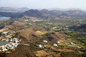
Stretching roughly 700 kilometres across Delhi, Haryana, Rajasthan, and Gujarat, the Aravallis are more than a geological marvel. They are a living, breathing lifeline. Formed two to three billion years ago, older even than the Himalayas, these hills block the encroaching Thar Desert, trap dust from sweeping into Delhi, and replenish millions of litres of groundwater every single day. They regulate local temperature, shelter wildlife, and hold together the fragile ecological balance of northern India. Yet today, this ancient range is being carved, sold and stripped away, its destruction disguised as “development”. For decades, the Aravallis have bled under the assault of unchecked mining and real estate sprawl. Mines for sandstone, marble, zinc and granite have gutted the landscape. Once lush slopes now lie fractured and barren, their water tables plummeting to frightening depths. By 2018, entire hills had vanished from Haryana’s maps; biodiversity collapsed, and the dust clouds rising from mining pits became a permanent part of Delhi’s air. Each truckload of rock carried away is another breath stolen from the city’s future. And now, the highest court in the land has handed a new weapon to those who profit from destruction.
The consequences are apocalyptic. More than 90% of the Aravalli range could lose its protection overnight. That means small ridges, scrub-covered slopes and low rocky formations, all essential to the ecosystem’s continuity, will be open to exploitation. According to data from the Forest Survey of India, only 8.7 per cent of the hills they mapped would still count under this definition. The rest, the living shield that guards North India from the desert, would be up for grabs. The Citizens’ Report by People for Aravallis, published in May 2025, documented groundwater depths falling to 1,000–2,000 feet across large parts of Haryana and Rajasthan. The same report links mining activity to respiratory illnesses, agricultural collapse and the vanishing of wildlife. In 2024, the Central Empowered Committee had urged the Supreme Court to declare the entire Aravalli zone a no-mining area. Those warnings were swept aside in favour of an industry-driven compromise. Already, the signs of crisis are visible. In towns like Alwar and Gurugram, summer heat burns harsher each year. Streams have dried up; wells lie abandoned and farmlands crack under relentless drought. Leopards and hyenas wander into villages in search of food and water, sparking fear and conflict. Each dust storm that sweeps through Delhi now carries the grit of the Aravallis, airborne evidence of neglect and greed.
The Supreme Court’s judgment sparked outrage because it betrayed the very principles of environmental justice that earlier rulings had upheld. In past landmark cases, the court had recognised the fundamental importance of these hills. But today, that legacy stands on shaky ground, replaced by a “management plan” that promises sustainable mining while weakening the very definition of what needs protection. It is a cruel paradox: the government speaks of a “Green Wall Project” even as it clears the ground of what little green remains. The ban on mining must be fully reinstated and expanded, not diluted. The entire range should be declared a critical ecological zone where no commercial exploitation is permitted. Reforestation on a war footing must follow, with local communities leading the effort and being paid to restore what was stolen. Each valley, each slope, each forgotten ridge that still stands deserves to be revived, not rewritten out of existence. Without these hills, the entire Braj bhoomi will choke, Haryana will parch, Rajasthan will burn, and the Thar will keep marching eastward until the desert meets the sea. The Aravallis must be saved in their entirety, or they will be lost forever.
Dr CP Rajendran
Adjunct professor at the National Institute of Advanced Sciences, Bengaluru, and co-author of the book: The Rumbling Earth – The Story of Indian Earthquakes
All of India’s mountain ranges are threatened by unsustainable development and the ancient Aravalli Range is the latest to attract people’s attention from all over the country. Stretching 700 km across northwestern India—through Gujarat, Rajasthan, Haryana and Delhi, the Aravallis are not only the subcontinent’s most ancient mountain chain; they also preserve a remarkably continuous, three-billion-year geological record spanning the Precambrian era (~3.6 to ~0.6 Ga). As such, the range serves as a direct archive of our planet’s earliest tectonic and evolutionary processes. In a highly controversial move, a central government panel has proposed redefining the Aravallis by imposing a new ‘height limit’ of 100 metres above the surrounding landscape. Under this criterion, internal assessments by the Forest Survey of India indicate that only 1,048 of the 12,081 mapped hills—a mere 8.7 per cent—would qualify for protection from mining and real estate expansion. The Aravalli Range performs a series of critical, interconnected ecological functions. It acts as a natural barrier, arresting eastward desertification from the Thar Desert and shielding the Gangetic plains from Central Asia’s dominant westerly winds. This very positioning also establishes it as a crucial climate regulator, influencing the trajectory of monsoon clouds towards the lower Himalayas. In doing so, it ensures the vital rainfall that supports rich biodiversity, agriculture and millions of livelihoods across northern India. This destruction would devastate the region’s natural defences and it risks accelerating long-term desertification in the National Capital Region—an area already grappling with some of the world’s worst air quality. Having endured for billions of years, the ancient Aravalli mountains now face a distinctly modern, anthropogenic danger. While natural processes like erosion and sedimentation have shaped these hills gradually over aeons, human activity now precipitates their degradation at a dramatically accelerated pace.
In October 2018, the Supreme Court was presented with a report from its Central Empowered Committee (CEC) stating that 31 Aravalli hills in Rajasthan had vanished due to illegal mining. The findings provoked a pointed judicial response. Justice Madan B Lokur, a member of the bench, remarked incredulously: “Have people become ‘Hanuman’ that they are running away with hills?” The court highlighted the staggering scale of illegal mining and the state’s failure to curb it. Shocked that roughly a quarter of the Aravalli range in Rajasthan had disappeared over 50 years, the bench strongly reprimanded the state government for ‘taking the issue very lightly’ and for endangering countless lives in pursuit of mining royalties.
Ironically, the Supreme Court, which in 2018 had reprimanded the Rajasthan government over the disappearance of the Aravalli hills, now accepted an elevation-based definition of the range on November 20, 2025. Following directions from the Supreme Court of India, a committee led by the Ministry of Environment, Forest and Climate Change (MoEFCC) was formed. In a controversial decision, the panel has established a new ‘elevation threshold’ for defining the Aravalli Range: any landform must rise 100 metres above the local relief to be included. This standard, based on the Richard Murphy landform classification system, is now proposed as a uniform criterion across all Aravalli states (Delhi, Haryana, Rajasthan, and Gujarat). The Murphy classification is an academic framework that employs quantitative measures—such as rock type, topography and relief—to systematically define landforms. It categorises relief over 300 metres as mountains and relief between 90 and 300 metres as hills. However, Indian authorities have critically overlooked a fundamental distinction: this system was designed for geographic analysis and cartography, not for land-use policy. It is a tool for understanding landscape morphology, not for earmarking terrain for commercial extraction like mining and real estate development. Applying its rigid height thresholds as legal criteria represents a profound misappropriation of a scientific tool, prioritising cartographic convenience over ecological reality.
According to press reports, internal assessments by the Forest Survey of India reveal the stark consequence of this criterion: of the 12,081 mapped hills, only 1,048—a mere 8.7 per cent—would qualify for protection. Consequently, vast tracts of low hills and ridges would be stripped of their previous legal safeguards, opening the door to rampant commercial exploitation. The Forest Survey of India’s geomorphic definition, endorsed by the Supreme Court’s own Central Empowered Committee (CEC), classifies hills with a slope of over three degrees as part of the Aravallis. This definition encompasses the vital lower hills that are excluded by the Ministry of Environment’s stricter 100-metre height threshold. The Supreme Court, by its decision on December 29, 2025, has now directed that recommendations of the committee shall remain in abeyance and also proposed a high-powered expert committee to come up with new guidelines. The case will be taken up on January 21, 2026.
For the Aravallis, governance must be guided by a functional perspective—one that prioritises a hierarchical framework centred on resource management, forest cover and ecosystem services, such as biodiversity corridors and watershed functions. This approach aligns with integrated land-use systems like the Anderson Land Use/Land Cover classification (1976). As a first step, a definitive functional boundary for the Aravalli Range must be established using GIS, employing the ecologically relevant 3-degree slope criterion endorsed by the Forest Survey of India. This will accurately map its true geomorphic footprint. Extending outward from this scientifically derived boundary, the government must legally designate a protective buffer zone of appropriate width. This zone, plus the hills beyond, must be placed permanently off-limits to mining, real estate development, and all other extractive or destructive activities to preserve its indispensable ecological functions.
Waterman Rajendra Singh
Renowned river rejuvenator and environmentalist
In the 1980s, when the entire Aravalli region was reeling under the pressure of mining, sand was being carried towards Delhi through 12 gaps in the Aravalli region by the western wind. Ten years later, when the Aravalli mines were closed in 1991, the Aravalli region began to revive. Those who were rendered unemployed by the closure of the mines became involved in water conservation. After mining ceased, the mines became water banks. After 2014, illegal mining in the Aravalli region accelerated again. This mining once again stripped the Aravalli region bare. Given these circumstances, it seems the Aravalli region will once again help bring sand from its west to its east. The Aravalli forests, which used to act as Delhi’s lungs, will now become useless, making the Aravalli and Delhi sick. We need to understand that, just as the closure of mines in the Aravallis after 1991 revived the Aravallis and accelerated water conservation efforts, the people of Delhi, Haryana, Rajasthan, and Gujarat need to do the same again and raise their voices. The Aravalli Bachao Movement of 1980 needs to be revived across Delhi, Haryana, Rajasthan, and Gujarat. In 1988, Jansi Meena of Palpur village, Gopi Kumhar of Tilwad, Roopnarayan Joshi of Tildah, and many others, while warming themselves by the fire in the evening, said: “Mining will prevent our wells from having water. There are mines deeper than the wells. No matter how much water you conserve, it will all go into the mines. Our wells will remain dry. It is beyond your power to close the mines. They will kill you or have you killed.” Undeterred, I set about stopping mining. I had a hard time proving the mining area was a forest area, then getting an order from the Supreme Court to stop the mining and getting it implemented. I also faced life-threatening attacks. The culprits were arrested, which increased fear among the mine owners and mining came to a halt. Except for stone-breaking, the Aravalli range contains all kinds of minerals—white marble, dolomite, granite, limestone, uranium and copper. It has been 33 years since these mines were closed. When both the judiciary and the executive showed a willingness to save the range, the mine owners also began to close their mines.
Since 2014, the Aravalli mountain range has once again faced a crisis. First, a shift in the definition of the Aravalli mountain range began. It was then that the Aravalli mountain range was defined as any hill higher than 100 metres. We argued that mountains were not solely defined by their height; their fundamental elements, structure, biodiversity, and the presence of numerous biodiversity components defined them. The government, driven by the frenzy of power, now seems insensitive and does whatever suits it. Repeated protests have fallen on deaf ears. The Indian government has now reduced the mining distance from the 10-km Bagh Project to 100 metres, down to 1km. Nowadays, it has even begun granting full approval for the conversion of Aravalli forest land into industrial land. Destruction in the Aravalli region is now rapidly unfolding. Stopping it is a significant challenge. To save the water, forests and land of the Aravalli region, the people of Aravalli will now have to launch a ‘Save Aravalli Movement’ like the one of the 1990s.
Know the govt stance too
The Indian government, through the Ministry of Environment, Forest and Climate Change (MoEFCC) and coordinated state efforts, claims to maintain robust protection for the Aravalli Hills, reiterating commitments to ecological preservation, banning new mining leases across the range and focusing on sustainable development while combating illegal mining with enhanced monitoring. Despite debates over defining the Aravallis' extent, the Centre emphasises its resolve to safeguard these hills as a vital ecological buffer, ensuring conservation through strict enforcement and eco-sensitive zones. The government has clarified that the Supreme Court–approved framework does not dilute Aravalli protection or allow large-scale mining. The government identifies illegal mining as the main threat and supports stronger monitoring and enforcement, including the use of drones and surveillance technologies.


Leave a comment