Travelogue
HN Singh
The writer is a Lions International Faculty Member, SPHEEHA, Naturalist, HAM Radio Licensee, trekker & mountaineer
My journey to the Pindari Glacier remains one of the most memorable adventures of my life. I had the privilege of visiting this stunning glacier twice, first in 1981 and again in 1984, each time discovering new beauty in the lap of the Kumaon Himalayas.
In 1981, the trekking expedition was jointly organised by Avadh Mountaineering Federation (5 members from Lucknow) and N.C.C. (15 cadets) from Rudrapur District, Udham Singh Nagar. Lt. Col. S.G. Gurha (Late) was commanding this expedition.
About the Pindari Glacier
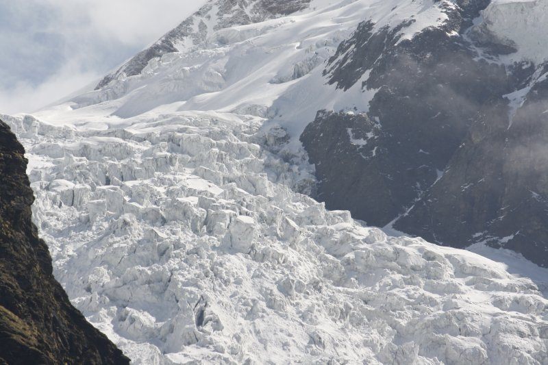
The Pindari Glacier lies in the upper reaches of the Kumaon Himalayas, southeast of Nanda Devi and Nanda Kot. It stretches for about 9 kilometres and gives rise to the Pindar River, which later meets the Alaknanda at Karnaprayag in Garhwal. The glacier is not the largest in the Himalayas, but few others offer such an easy and scenic approach to a mighty icefall. The trek is around 90 kilometres (round trip) and usually takes 6 to 8 days to complete, passing through some of the most picturesque villages and forests of Uttarakhand.
The trail
The route to the glacier passes through Saung, Loharkhet, and the Dhakuri Pass before reaching Khati, the last inhabited village on the trail. From there, trekkers proceed to Dwali, Phurkiya, and finally Zero Point, Pindar, which marks the end of the trail. Though the path often follows the Pindar River, the river itself remains hidden for long stretches, only revealing its beauty after Khati. The trek is considered moderate in difficulty, ideal for both beginners and families. It combines well-marked trails, mountain ridges, forest walks, and a few steep climbs. The maximum altitude reached is about 12,300 feet (3,800 metres), and the gradual ascent makes it manageable even for those new to high-altitude trekking.
A trek where zero means success
The Pindari Glacier trek is often described as a full-course meal for trekkers. The journey begins with easy walks through peaceful rhododendron forests, where birds fill the air with their songs. Then come the mountain ridges, river crossings, and narrow paths carved along rocky slopes. Finally, the “dessert” of the journey is the breathtaking sight of the Pindari Glacier at Zero Point, glowing under the sun at 12,300 feet. Standing there, surrounded by snow-covered peaks, one feels a sense of complete fulfilment and peace.
Historical notes
The Pindari and Milam Valleys were once part of ancient trade routes connecting India with Tibet. In 1830, G.W. Traill, the first Deputy Commissioner of Kumaon, explored a new route to Martoli in the Milam Valley through the Pindari Glacier and a high mountain pass later named Traill’s Pass (17,700 feet). Over the years, many explorers and expeditions — such as Schlagintweit (1850), Ruttledge (1926), and Arnold Heim (1937)- followed in his footsteps, mapping and documenting this beautiful valley.
TREKKING ITINERARY
Day 1: Loharkhet to Khati : We began our trek from Loharkhet (5,774 feet), climbing steadily towards and then descending to Khati village (7,549 ft) via Dhakuri pass(8,793 ft) . The trail wound through oak and rhododendron forests, offering cool shade and refreshing streams. Covering a distance of 10 km from Loharkhet to Dhakuri pass & from Dhakuri Pass to Khati- 9 km. By evening, we reached Khati, the last inhabited village on the trail, nestled below majestic peaks like Nandakot and Nandabaner. Now, with improved road connectivity, a proper motorable road extends all the way to Kharkiya, making it much easier for trekkers and visitors to start their trek to Khati, Dwali, Phurkiya, and Zero Point from there.
Day 2: Khati to Dwali: The next day, we started early to avoid the afternoon rain. The 13 km trail to Dwali (8,566 ft) was steep and narrow, winding through dense forests. The roar of the Pindar River echoed below us. At times, the path disappeared among rocks and landslides, but our local guide helped us stay on track. Dwali was a quiet resting place surrounded by towering cliffs and the sound of gushing water, a perfect mountain halt.
Day 3: Dwali to Phurkiya: The trek from Dwali to Phurkiya was 5 km (10,465 ft). Though short, it involved a steep climb. We crossed several icy streams and hiked through blooming rhododendron forests. From open meadows, we caught our first glimpses of Nanda Khat and even the distant peak of Nanda Devi East. We camped at Phurkiya, where the PWD Guest House keeper served hot tea, a true luxury in the mountains. As the sun set behind the peaks, the valley glowed with golden light.
Day 4: Phurkiya to Zero Point and back: We started before sunrise for the final push to Zero Point from Phurkiya (distance 8 km.) 7 altitude 12,300 ft. The air grew thinner, and patches of hard snow made the trail slippery. Soon, the mighty Changuch (6,322 m) and Nandakot (6,861 m) came into view.
Finally, we reached the vantage point marked by a small board, “You have reached Zero Point.” In front of us lay the vast Pindari Glacier, its frozen river of ice flowing from the heights of the mountains. The amphitheatre of peaks surrounding it was breathtaking. It was a moment of pure silence and awe, a sense of being one with the Himalayas. After spending time soaking in the view, we retraced our steps back to Phurkiya.
A mysterious encounter on the way to Zero Point
On the day we started from Phurkiya to Zero Point, I was part of the advance party of two members. We began very early, as we had to return the same day from Zero Point to Phurkiya. The moonlight made it easy to see our path. After walking for about half an hour, we noticed some movement ahead on the trail. For a moment, we were a bit frightened; this area is known for the presence of bears. But soon we realised it was a human figure coming down from above. At Phurkiya Guest House, we had been told that there was no camp beyond, so we wondered who this person could be. As the figure came closer, it became clear, it was a sadhu, dressed in a single white cloth. We stopped in our tracks, and our hands folded instinctively in reverence. The saintly figure walked past us silently. That sight is still vivid in my memory; even today, whenever I recall it, I get goose bumps. There was no fear, only a deep sense of peace and safety. Later, when the rest of the team arrived, we asked if they had seen the sadhu, but none of them had. Pan Singh, our guide & porter, explained that ascetics often meditate in caves around this area; perhaps it was one of them, moving from one cave to another. This experience has remained unforgettable to this day.
Day 5: Phurkiya to Khati via Dwali: We began our descent, following the same path through Dwali back to Khati. The journey down felt easier, and the changing light revealed new colours in the landscape. By evening, we reached Khati once again, feeling a sense of accomplishment and gratitude.
Day 6: Khati to Dhakuri and Loharkhet: The final day was a short walk from Khati to Dhakuri, and then by trail to Loharkhet, where we stayed overnight at the PWD Rest House. The next morning, we took the bus back to Almora via Bageshwar, carrying memories that would last a lifetime.
The Pindari Glacier Trek is more than just a mountain journey; it is a spiritual experience. The serenity of the forests, the kindness of the local villagers, and the grandeur of the Himalayan peaks combine to create something truly unforgettable. Whether you are an experienced trekker or a first-time adventurer, the Pindari Glacier welcomes all. And as the saying goes among trekkers, “At Pindari, reaching Zero is reaching the top!”- ([email protected])


Leave a comment