Expert Expressions
Dr CP Rajendran is an adjunct professor at the National Institute of Advanced Sciences, Bengaluru, and co-author of the book: The Rumbling Earth – The Story of Indian Earthquakes
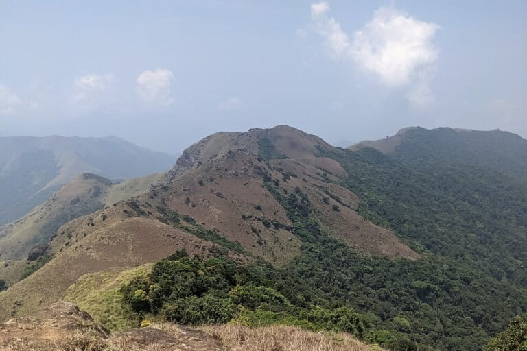
The Western Ghats, also known as the Sahyadri or "benevolent mountains," form a majestic 1,600-kilometre-long chain running parallel to the western coast of the Indian peninsula. This UNESCO World Heritage site spans six states—Gujarat, Maharashtra, Goa, Karnataka, Kerala and Tamil Nadu—and is celebrated as one of the world's most biodiverse regions. The astonishing array of ecosystems, ranging from tropical rainforests and high-altitude shola grasslands to countless waterfalls and serene rivers, solidifies its status as a global biodiversity hotspot.
The range earned the name 'Ghats'—meaning 'stairway'—from its distinct step-like morphology, which can be broadly categorised into three altitudinal zones: the highlands, midlands, and lowlands. Each zone is defined by its elevation, slope and unique ecological characteristics. The highland zone consists of high-altitude peaks and plateaus. It receives the highest rainfall and is characterised by shola grasslands and dense evergreen forests. The Midlands is a transition zone featuring lower-lying hills and forested slopes, marking a shift between the high elevations and the plains. The lowlands comprise the lowest elevations and include valleys and gentler slopes that gradually lead toward the coastal plains or the Deccan Plateau in its central parts.
How does this mountainous terrain paralleling the west coast of India come into existence? Are they true mountains, comparable to the Himalayas or Alps? Mountains like the Himalayas or the Alps are formed at the advancing edges of tectonic plates through the initial stage of subduction and the later stage of collisions. The Himalayas are a result of the tectonic collision between the Indian and Eurasian plates, causing the Earth’s crust to buckle and form the massive mountain range as we see today. The formation of the Himalayan mountains also involved the closure of an ancient sea, called the Tethys, which occupied a vast trough between the Indian and Eurasian plates. The slow northward movement of the Indian plate over millions of years, located south of the equator, was narrowing the Tethys and the final collision of the plates saw its disappearance. The remnants of sea rocks and sediments of the Tethys sea floor can be found in places like Ladakh, which geologists use to reconstruct the geological history.
While the northern edge of the Indian plate was colliding against the Eurasian plate to form the Himalayas, its western margin was undergoing a different, massive geological process: thermally induced continental rifting. Unlike the active, convergent northern boundary, the western margin was a passive, trailing edge, being pulled apart by forces associated with this rifting.
As the Indian plate drifted northeastward, the western section began to separate from the Madagascar and Seychelles plates. This rifting caused the landmass to split, with seafloor spreading creating a new ocean basin between the diverging continental fragments. The Western Ghats escarpment on the Indian side and the Angavo escarpment in eastern Madagascar are the matching rifted margins of this ancient breakup. All these terrains were once integral parts of the supercontinent Gondwana. The rifting process that formed the Western Ghats began approximately 80-90 million years ago, as India started its journey from Gondwana to its present position.
After its detachment from Gondwana, the Indian plate drifted over the Réunion hotspot—a volcanic upwelling in the Earth's mantle. A massive eruption from this hotspot around 65 million years ago produced the Deccan Traps, the vast plateau of basalt lava that covers much of central India. This volcanic activity was directly responsible for forming the northern third of the Western Ghats. Unlike the southern Ghats, which are a faulted rift edge, this section was created by volcanic upthrusts. Because these uplifts are dome-shaped, they expose older bedrock dating back approximately 200 million years, which can be observed in elevated regions like the Nilgiris.
After the break-up, the western coast of India would have appeared as an abrupt cliff some 1,000 metres in height. Since that initial breakup, the distinct morphology of the lowlands, midlands, and highlands has been sculpted over millions of years by relentless erosional forces. The step-like topography we see today is not just a relic of rifting, but a dynamic landscape continuously sculpted by monsoon rains, rivers and weathering.
The Western Ghats are significantly older than the Himalayas. This geological antiquity has provided a long and relatively stable environment, allowing life to evolve and diversify over millions of years without the extreme disruptions caused by major ongoing mountain-building events. This prolonged period of stability is a key factor behind the region's status as a global biodiversity hotspot. Thus, the Western Ghats became a sanctuary for biodiversity, hosting thousands of species of flora and fauna, a remarkable proportion of which are endemic. Although they cover less than 6% of India's land area, the Ghats are home to more than 30% of the country's plant, fish, reptile, amphibian, bird and mammal species. Beyond this ecological treasure, these verdant highlands serve as a vital water tower for peninsular India. They are the source of major rivers like the Godavari, Krishna, Kaveri and Bharathapuzha. For millennia, these life-giving waters have nurtured the southern plains, sustaining civilisations and shaping rich cultural traditions.
The Western Ghats became a biodiversity hotspot due to its ancient, stable, and isolated environment that allowed for gradual, long-term species evolution and the accumulation of a high number of endemic species. This process was further fuelled by the geographic and climatic diversity within the mountain range, which supports various ecosystems like tropical evergreen forests and shola forests, as well as the high volume of rainfall from the monsoons that creates a fertile, life-sustaining, perpetual humid environment. This unique wet and favourable climate is the fundamental driver behind the evolution of the region's vast array of flora and fauna, including its remarkable number of endemic species.
The Western Ghats were once celebrated for their breathtaking natural beauty—a landscape defined by cascading waterfalls, lush greenery, and a dazzling array of flora and fauna. Today, however, this idyllic image is undergoing a stark and perilous transformation. The region is now besieged by a confluence of threats, including the escalating impacts of climate change, recurring landslides, widespread deforestation, decline of traditional livelihoods, rampant land encroachment and the consequent displacement of its indigenous tribal communities.
In 2011, the Western Ghats Ecology Expert Panel (WGEEP), chaired by Prof Madhav Gadgil, submitted a landmark report focused on the protection and sustainable development of the region. Its key recommendations included imposing strict regulations—such as bans on mining, construction, and polluting industries in designated Ecologically Sensitive Areas (ESAs)—and adopting a bottom-up approach that involved local communities in conservation efforts.
Despite its scientific rigour and foresight, the Gadgil Report has remained largely unimplemented. The very issues it warned against, such as devastating landslides in ecologically fragile zones, have continued to recur with increasing severity. In recent writings, Gadgil has reiterated that a solution lies in the effective implementation of the Forest Rights Act (FRA), particularly in the assignment of Community Forest Rights to the indigenous populations who have inhabited these forests for generations. He argues that this form of democratic decentralisation, by empowering local communities as stewards of their environment, is essential for the region's ecological revival and would foster a more inclusive and effective decision-making process. ([email protected])


Leave a comment