

In a landmark shift for India’s environmental jurisprudence, the Supreme Court-appointed High-Powered Committee (HPC) has officially rejected the use of a single, uniform terrain- or height-based yardstick to delineate the ancient Aravalli hill ranges. Moving away from rigid, one-size-fits-all engineering metrics, the expert panel submitted a compliance report introducing a multi-dimensional "Aravalli Ecosystem Landscape (AEL)" framework. To build a transparent, reproducible, and scientifically defensible assessment, the committee has formally requested a six-month extension from the apex court, shifting its final deadline to 28 February 2027.
The Genesis of the Dispute: A Faulty Metric
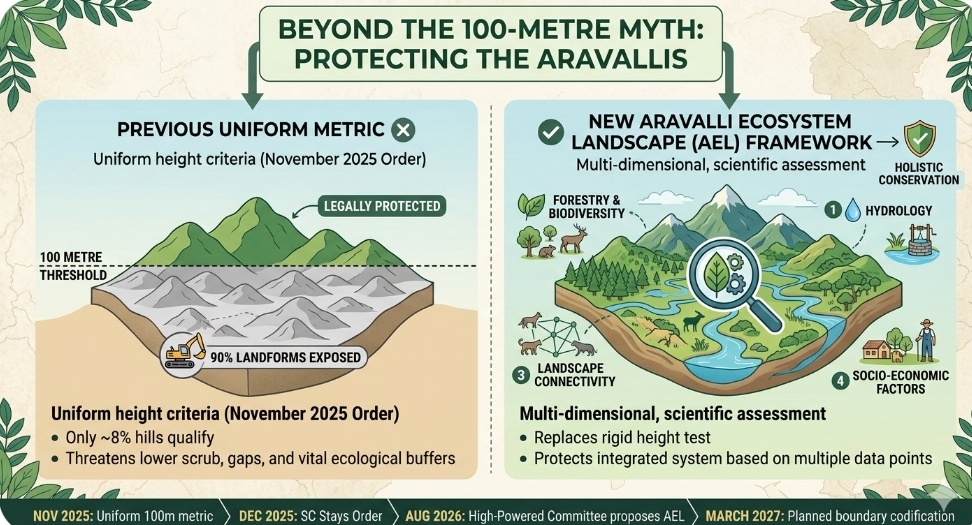
The current legal standoff traces back to a 20 November 2025 Supreme Court judgment. In that ruling, the apex court adopted a uniform definition recommended by an earlier committee spearheaded by the Union Ministry of Environment, Forest and Climate Change (MoEF&CC). Under that specific criterion, a landform was legally classified as a protected "Aravalli Hill" only if it rose 100 metres or higher above the local relief. Clusters of such hills located within 500 metres of each other were designated as an "Aravalli Range".
While intended to streamline regulation, the math behind the metric triggered immediate panic among environmentalists, tribal leaders, and data scientists. A devastating dataset compiled by the Forest Survey of India (FSI) revealed a structural paradox: of the 12,081 distinct hills mapped across the range, only 1,048 (a mere 8.7%) met the 100-metre threshold.
In states like Rajasthan and Haryana, this meant that over 90% of the lower scrub hills, spurs, and gaps would instantly lose their protected status. This regulatory loophole threatened to open vital ecological buffers—which prevent the expansion of the Thar Desert toward the National Capital Region (NCR)—to indiscriminate real estate development and commercial mining lobbies.
Recognising the catastrophic risks, the Supreme Court took suo motu cognisance of the public outcry and issued an order on 29 December 2025, staying its own November ruling and placing the 100-metre definition in complete abeyance. By a subsequent order on 25 May 2026, the court constituted the current High-Powered Committee to execute a comprehensive, independent review.
Key Judicial & Committee Declarations
The HPC's compliance report argues that ecosystems cannot be managed through arbitrary administrative boundaries.
"The Aravalli hill range is a complex, interconnected system and cannot be delineated using a single, terrain-based yardstick alone," the committee noted in its official filing.
The panel further explained that arriving at an unassailable definition requires a synthesis of wide-ranging data:
"The committee needs to bring together spatial, ecological, geological, hydrological, socio-economic, and stakeholder evidence before arriving at its final conclusions."
The bench has previously noted that public interest and the preservation of India’s oldest mountain system must override simplified bureaucratic convenience. Rather than looking blindly at topographic elevation, the court’s mandate requires checking whether commercial activities like mining will compromise the ecological continuity of the gaps and corridors within the range.
Implementation: The AEL Framework
The newly proposed Aravalli Ecosystem Landscape (AEL) framework systematically dismantles the height test. Instead of viewing the range as a collection of isolated, measurable peaks, it assesses the Aravallis as an interconnected bio-system. The execution model relies on four core pillars:
- Hydrological Mapping: Protecting lower ridges that act as critical groundwater recharge zones for water-stressed northern plains.
- Landscape Connectivity: Ensuring continuous wildlife corridors remain protected, even if the terrain falls below 100 metres in altitude.
- Geospatial and Digital Elevation Models (DEM): Using advanced satellite data from the Survey of India to generate transparent, verifiable boundary lines.
- Socio-Economic Integrity: Assessing local tribal and forest-dweller livelihoods to balance community dependencies with ecological protection.
Public and Industry Reactions
- Environmental Activists: The decision has been met with immense relief. Conservation groups noted that treating a mountain range purely by its height is ecologically illiterate, as the lower hills often bear the brunt of desertification control.
- Mining and Real Estate Lobbies: The corporate sector faces prolonged gridlock. With the Supreme Court maintaining a strict moratorium on the allocation of any new mining leases in contested areas until final boundary lines are drawn, several massive infrastructure and extraction projects remain entirely frozen.
- Local and Tribal Communities: While supportive of environmental safety, local representations submitted during public hearings in August highlighted anxieties over potential displacements, urging the committee to ensure "differentiated conservation approaches" that do not criminalise traditional forest access.
What to Expect Next
The immediate operational impact is a state of regulatory stasis. The HPC has received over 680 physical and electronic representations from the public and conducted extensive ground validations across Delhi, Haryana, Rajasthan, and Gujarat.
Because the 100-metre rule remains frozen, the previous strict protective measures remain active. No new mining leases for general minerals will be processed within the traditional historical boundaries of the Aravallis. The Supreme Court is expected to grant the requested extension, meaning that stakeholders must wait until at least March 2027 for the final, digitally mapped "inviolate zones" to be formally codified into law.
Editor’s Note
The battle over the Aravallis is no longer just an environmental dispute; it is a fundamental test of how our legal systems define and protect nature. When a uniform 100-metre elevation benchmark threatened to leave more than 90% of this ancient mountain system exposed to relentless exploitation, the judiciary wisely paused. Now, with the High-Powered Committee's latest intervention, we are witnessing a paradigm shift from rigid bureaucratic line-drawing to a holistic, scientific understanding of ecosystems. At TreeTake, we view this transition as a significant milestone. It moves us away from treating forests and ridges as isolated obstacles to industrial growth and acknowledges them as a deeply interconnected lifeline for the northern plains. This comprehensive report unpacks the legal timeline, the structural flaws of the past metric, and the newly proposed framework that could change conservation in India forever.


Leave a comment