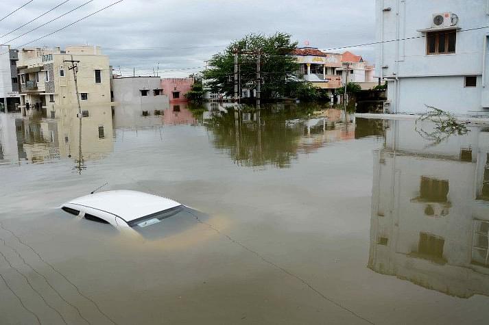
Indian monsoon season, running from June to September has become more unpredictable due to climate change. We have seen rains all our lives, but the damage and the disaster have not been to the level we see now. Now urban floods- which were a comparatively new phenomenon in India till sometime back- have become an annual feature. The floods cause major damage to irrigation infrastructure, roads, and public communities as well as loss of human life and livestock. The floods also damage household durable assets and motor vehicles, and render many homes uninhabitable. Unfortunately, the authorities have done little to learn from the past…
Arunima Sen Gupta
The northeastern state of Assam is facing a second wave of floods as the Brahmaputra water level has increased and is flowing above danger levels due to release of water from Bhutan. Around 98,800 people have been affected in 371 villages of 13 districts according to the Assam State Disaster Management Authority (ASDMA). Parts of the Kaziranga National Park and Tiger reserve has been submerged too. Meanwhile, at least 62 persons have lost their lives in rain-related incidents in Punjab and Haryana during the recent spell of torrential downpour that battered parts of northern India. The Indian Meteorological Department has issued flash flood warning with heavy to very heavy rainfall in parts of Himachal, Uttarakhand, East Rajasthan, East MP, Konkan and Goa.
It is important to mention here that heavy rainfall during the 2023 monsoon season resulted in severe flooding and landslides across Northern India, primarily affecting residents in Himachal Pradesh, Punjab, Chandigarh, Uttarakhand, Jammu and Kashmir, Haryana, Rajasthan and Delhi. A monsoon surge, coupled with a western disturbance has led to the highest rainfall in decades in some parts of the region, causing nearby rivers to overflow, with flooding and landslides washing away vehicles, destroying bridges and roads, and disrupting power and electricity. At least 105 individuals across Himachal Pradesh, Uttar Pradesh, and Delhi, were killed over a two-week period of intense rain and flooding, with thousands of others evacuated to relief camps. The floods have led to closure of schools, disruption of flights and train operations in various parts of North India. The devastating floods across North India have renewed attention on the dynamic between climate change, urbanisation and the infrastructural lacunae that bedevil India’s large cities.
Another period of intense torrential rain continued in August, and at least 71 more persons were killed in Himachal Pradesh, while 10 others died in Uttarakhand. “Recent Himachal Pradesh floods remind us of the 2013 Uttarakhand floods with similar synoptic conditions. An active monsoon with strong low level easterlies bringing plenty of moisture, supported by upper level divergence due to an east-ward moving trough. These are predictable,” said M Rajeevan, former secretary, ministry of earth sciences. “Recent heavy rains & flash floods remind us one of important impacts of climate change on monsoon. It rains fewer hours, but when it rains, it rains very heavily. Our forewarning systems & mitigation should further improve This can happen anywhere,” he recently tweeted.
Landslides and floods are common in India’s Himalayan north during the June-to-September monsoon season. Scientists say they are becoming more frequent as global warming contributes to the melting of glaciers there. In February 2021, flash floods had killed nearly 200 persons and washed away many houses in Uttarakhand. And this nature’s fury is not limited to India. Millions of people across Bangladesh and Nepal have been affected by floods caused by monsoon rains. In Nepal, thousands of families have been forced to flee their homes to escape the floods that have claimed lives, destroyed homes and ruined food stocks. In northern and central Bangladesh, 3.9 million people have been directly affected by the flooding that has claimed 89 lives. An estimated 1,000 schools are closed due to the flooding disrupting learning for children.
"In a changing climate, we see that hilly areas and surroundings - whether it's the Himalayan foothills or the Western Ghats - are particularly susceptible to heavy rains and landslides. Due to global warming, there's extra moisture, and the hills stop this moisture flow and lift it, which comes down as heavy rains. Some of the regions over India where extreme rains have increased are such places where the rains happen due to orographic lifting," said Roxy Mathew Koll, climate scientist at Indian Institute of Tropical Meteorology. "Flash floods due to cloudbursts and extreme rains are difficult to predict. We should monitor these events closely and identify areas prone to flash floods. We will have to depend on radars in such hazardous environments to monitor and forecast these events. With a radar, the maximum lead time that we could get is about 3 hours before such an event. We should also check the land use changes and development activities that might have aggravated these flash floods," he added.
India’s monsoon season, running from June to September, has become more unpredictable due to climate change, experts say. “Now is the time to consider that these unprecedented and erratic events will be more frequent and more intense in times to come,” said Abhiyant Tiwari, who leads health and climate resilience in India for the Natural Resources Defense Council. “We are not going to escape from the imminent effects of climate change, regardless of our mitigation and adaptation efforts.”
“It is one of the worst floods I have ever seen in my lifetime,” said Tikender Singh Panwar, the former deputy mayor of the state capital, Shimla, who is now a climate and urban activist. “It’s really catastrophic. And we can understand that the principal reason is climate change. That is not new.” Panwar said that scientists had warned the state’s authorities that they would begin seeing higher rainfall in a shorter time frame more often. He said the disaster was caused by hydropower projects and infrastructure, like widened roads, for tourists — necessities for the smaller state to attract money. Shimla has a population of 200,000 but receives six million tourists a year. “We’ve seen rains all our lives, but the damage and the disaster have not been to the level we see now,” said Panwar. “I never used to see muddied waters in the rain. Now the rivers are brown because the roads were constructed without mountain ethos and ethics. It’s a planned destruction of the Himalayas.”
Understanding the situation with a past example
Urban floods are a comparatively new phenomena in India. Preparedness and mitigation measures for these floods are different from riverine floods which occur in identified flood prone regions in the country. For example: Tamil Nadu, which does fall under the flood risk zone, recorded an exceptionally heavy rainfall during November 2021 due to Northeast monsoons. This led to devastating floods in Chennai and adjoining areas, or so we are told. The floods caused major damage to irrigation infrastructure, roads and public communities as well as loss of human life and livestock. The floods also damaged household durable assets and motor vehicles, and rendered many homes uninhabitable. Unfortunately, the floods are a recurring phenomenon and the authorities have done little to learn from the past.
In what respect are urban floods different from the riverine floods?
The National Disaster Management Authority states: “Urban flooding is significantly different from rural flooding as urbanization leads to developed catchments, which increases the flood peaks from 1.8 to 8 times and flood volumes by up to six times. Consequently, flooding occurs very quickly due to faster flow times (in a matter of minutes). Urban areas are densely populated and people living in vulnerable areas suffer due to flooding, sometimes resulting in loss of life. It is not only the event of flooding but the secondary effect of exposure to infection also has its toll in terms of human suffering, loss of livelihood and, in extreme cases, loss of life. Urban areas are also centres of economic activities with vital infrastructure which needs to be protected 24x7. In most of the cities, damage to vital infrastructure has a bearing not only for the state and the country but it could even have global implications. Major cities in India have witnessed loss of life and property, disruption in transport and power and incidence of epidemics. Therefore, management of urban flooding has to be accorded top priority. Increasing trend of urban flooding is a universal phenomenon and poses a great challenge to urban planners the world over. Problems associated with urban floods range from relatively localized incidents to major incidents, resulting in cities being inundated from hours to several days. Therefore, the impact can also be widespread, including temporary relocation of people, damage to civic amenities, deterioration of water quality and risk of epidemics.”
What are the reasons for continued floodings?
Sekhar Raghavan, Director, Rain Centre, Chennai, comments: “Chennai experienced floods during November 2021, which is the third in the last two decades. The previous ones were in 2005, and 2015, which were for a different reason than the recent one. While release of excess water from irrigation tanks located in the adjoining districts of Kanchipuram and Thiruvallur, in particular the Chembarambakkam tank was the reason attributed to the previous ones, whereas, the rains that fell on Chennai and that too in the first spell of northeast monsoon itself flooded the city.”
“Stormwater drains not being efficiently designed and not being maintained well, lack of maintenance of the waterways and the few nullahs within the old city as well as the waterbodies within the extended areas, intense rainfall in a short period of time, urbanization were the other common reasons for the urban floods. In a large majority of areas, the shallow groundwater level was very high even before the onset of the NE monsoon. We at the Rain Centre, witnessed this while implementing RWH in several areas of Chennai. It was imminent that it would rise even in the first spell of the NE monsoon. It happened. Groundwater levels in several areas of Chennai are at ground level now, leaving no space for any more rains to percolate into the soil. This has led to inundation, water logging and floods in most parts. Fortunately, it did not rain much after the 27th of November, otherwise the flooding would have been more severe,” he adds. On the question of why groundwater was high this year, he comments: “The rainfall has been extremely good for almost one full year (since October 2020) which kept the groundwater levels of Chennai high. Secondly, the metro water supply was very good during the past one year in almost all the localities of Chennai. Because of this, citizens did not tap their groundwater source and hence their levels remained high.”
Dr Vibhuti Rai, retired professor, Department of Geography, University of Lucknow, says: “There is no one-size-fits-all approach that can be cited as a reason for the floods. There are a variety of reasons that have together contributed to the state of affairs. The city receives rainfall primarily due to two reasons- the first one being cyclonic rainfall which composes a bigger chunk than the second one, that is the North East monsoons, also known as the retreating monsoons. In a way both these factors are linked together. The cyclonic depression that is formed in the Bay of Bengal is responsible for the intensity of the rains that will be there. When the depression formed is deeper, the intensity of the rainfall will be more because as the retreating monsoon passes over the Bay of Bengal region, it picks up moisture, which is then experienced as torrential rainfall on the coastal areas. The depression formation has been increasing in intensity due to climate change related factors, wherein the temperatures are rising. So, it is not completely a natural disaster.”
What part can be attributed to the urban planning?
Jairam Venkatesan from Arappor Ikayam, an NGO working on the issue, comments: "The first and foremost reason is gross mismanagement of water resources. Massive maladministration that has legalized encroachments over our water bodies is the primary reason. In fact, these are water bodies only in name. The authorities, far from removing such encroachments have actually contributed to it. Secondly, there is the issue of faulty construction of storm water drains. The storm water drains are different than the usual sewage drains in the respect that they are designed to connect the low-lying areas of the city to the major canals and the rivers. These storm water drains are being constructed without consideration of the gradient. The government has spent more than 5-6 crores, yet they are defeating the entire purpose. The result is for all to see.”
The issue about the wetlands is a well-known one. Only 15% of Chennai’s wetlands are left, according to a study by Chennai-based Care Earth Trust, a biodiversity research organization. Their findings show that Chennai’s built-up area grew from 47 sq. km in 1980 to 402 sq. km in 2012, while wetlands declined from 186 sq. km to 71 sq. km. But the authorities remain oblivious to the fact. Jairam Venkatesan comments: “We have been campaigning against raising road heights and asking government to mark the boundaries and restore waterbodies. But we were surprised to learn during field visits that of the 40,000 odd tenders issued in 2019 (for the restoration of the waterbodies), half of the work has not even been begun after 2 years.” An email enquiring the same from the Greater Chennai Corporation by TreeTake was not answered.
Dr Vibhuti Rai comments: “The topography of a city along with development of the city is responsible. When we talk about the topography, the regional slope is towards the East. Along with that the continental shelf, which is the stretch of the land that extends into the ocean, is quite narrow for Chennai. So, it seems like the city is situated on the brink of the ocean. This is not usually the case with other coastal areas. Then we also have to take into account that the city is an ancient one, which means that it is not planned but spontaneously designed. But this fact does not exempt the current dispensation to overlook urban planning when it can be, in fact, improved. Therefore, the drainage pattern should be such that it can tackle even the worse off situations,” he adds.
The National Disaster Management Authority too attests to the fact: “Among the important cities of India, the average annual rainfall varies from 2932 mm in Goa and 2401 mm in Mumbai on the higher side, to 669 mm in Jaipur on the lower side. The rainfall pattern and temporal duration is almost similar in all these cities, which receive the maximum rainfall from the south-west monsoons. The average rainfall for the month of July in Mumbai is 868 mm and this far exceeds the annual average rainfall of 611 mm in London. Stormwater drainage systems in the past were designed for rainfall intensity of 12 – 20 mm. These capacities have been getting very easily overwhelmed whenever rainfall of higher intensity has been experienced. Further, the systems very often do not work to the designed capacities because of very poor maintenance. Encroachments are also a major problem in many cities and towns. Natural streams and watercourses have formed over thousands of years due to the forces of flowing water in the respective watersheds. Habitations started growing into towns and cities alongside rivers and watercourses. As a result of this, the flow of water has increased in proportion to the urbanization of the watersheds. Ideally, the natural drains should have been widened (similar to road widening for increased traffic) to accommodate the higher flows of stormwater. But on the contrary, there have been large scale encroachments on the natural drains and the river flood plains. Consequently, the capacity of the natural drains has decreased, resulting in flooding. Improper disposal of solid waste, including domestic, commercial and industrial waste and dumping of construction debris into the drains also contributes significantly to reducing their capacities. It is imperative to take better operations and maintenance actions.”
The 2015 floods: Nothing learnt from the past
A case study by the Tamil Nadu State Disaster Management Authority on the 2015 floods in the city, attests the happenings in the city in these words: “Tamil Nadu recorded an exceptionally heavy rainfall during November - December 2015 due to the North East Monsoons. This unprecedented rainfall took place in four spells: November 8-10, 2015 causing extensive damages, mainly in Cuddalore district; November 12-13, 2015 severely affecting Kancheepuram town; November 15-17, 2015 bringing heavy rain to Chennai and the adjoining districts of Kancheepuram and Thiruvallur; and November 30 to December 7, 2015 which again hit Chennai and the two adjoining districts with such great intensity that it marooned large parts of the metropolis causing severe damage and destruction, and marooning large parts of the metropolis with people stranded on rooftops for days together, especially in the low-lying areas. While the first three spells of rains caused flooding in many districts of Tamil Nadu, causing damages to infrastructure and property and distress to people, the final spell on 2nd December, 2015, flooded densely populated areas of Chennai Metropolis and adjoining districts of Kancheepuram and Thiruvallur. This unprecedented rainfall in a short duration led to devastating flash floods causing major damages to irrigation infrastructure, roads and public amenities as well as loss of human lives and livestock.” The report makes tall claims like: “Each disaster presents an opportunity to learn from it. The Tamil Nadu Government used the opportunity presented to it after the December 2015 deluge to strengthen disaster preparedness in the State.”
The report goes on to recount the measures taken by the government for the future disasters. “Besides immediate relief measures, Govt of Tamil Nadu had also undertaken a slew of long-term measures to prevent the recurrence of a similar disaster situation in the future. These initiatives address the fundamental causes underlying such catastrophes and can easily be contextualized for major cities across the country. • Master Plan 2030, drawing lessons from the 2015 deluge, is under preparation. This will result in an institutional framework to manage disasters of such magnitude by way of a long-term plan. • Long-term conservation and response plans are being drawn. • Regulation of tanks/reservoirs is being prepared. • Classification and subsequent mapping of both rural/urban areas to decide their vulnerability to flooding depending on inundation: 5ft. and above water - high vulnerability; 2-3 ft. water - moderate vulnerability, less than 2 ft. water - low vulnerability, etc.” But the sad reality is that nothing extraordinary has been learnt from the past. At least the 2021 scenario stands testimony to this.
Urban floods in India- A look into the past to rectify the future
As a part of its mandate, the National Disaster Management Authority (NDMA) has made efforts to prepare the National Guidelines on Management of Urban Flooding. Even though urban flooding has been experienced over decades in India but sufficient attention was not given to plan specific efforts to deal with it. In the past, any strategy on flood disaster management largely focused on riverine floods affecting large extents of rural areas. Mumbai floods of July 2005 turned out to be an eye-opener. Realizing that the causes of urban flooding are different and so also are the strategies to deal with them, NDMA has for the first time decided to address urban flooding as a separate disaster, delinking it from floods. There has been an increasing trend of urban flood disasters in India over the past several years whereby major cities in India have been severely affected. The most notable amongst them are Hyderabad in 2000, Ahmedabad in 2001, Delhi in 2002 and 2003, Chennai in 2004, Mumbai in 2005, Surat in 2006, Kolkata in 2007, Jamshedpur in 2008, Delhi in 2009 and Guwahati and Delhi in 2010. A special feature in India is that we have heavy rainfall during monsoons. There are other weather systems also that bring in a lot of rain. Storm surges can also affect coastal cities/ towns. Sudden release or failure to release water from dams can also have severe impact. In addition, the urban heat island effect has resulted in an increase in rainfall over urban areas. Global climate change is resulting in changed weather patterns and increased episodes of high intensity rainfall events occurring in shorter periods of time. Then the threat of sea-level rise is also looming large, threatening all the coastal cities. Cities/towns located on the coast, on river banks, upstream/ downstream of dams, inland cities and in hilly areas can all be affected.
Suggestions and way forward
Sekhar Raghwan suggests: “There are no immediate solutions for the problem of flooding except to pump it out wherever possible or remain patient till it subsides. There are of course long-term solutions to be adopted by both the society (citizens) and the state (government). Citizens should start tapping the shallow groundwater source through open wells or shallow tube wells and reduce or stop consuming metro water. This will help us to deplete the water table enabling flood waters to recede. Deep bore wells will not help us to do this since they tap a deeper (different) layer of groundwater source. The water supply and sewerage bodies themselves have got open wells in many of their area and depot office premises. In addition, they have also constructed large-sized overhead tanks in many locations. They should decide to extract groundwater from these open wells, pump it up to the OHTs and supply water to the neighbourhood. This will also help to deplete groundwater level, which in turn will mitigate waterlogging. The Government should install water meters for the domestic consumers also and charge according to the consumption, almost similar to electricity. The more they consume, the more they pay. This will help to motivate the residents to tap their shallow groundwater source and deplete it. The authorities concerned can also adopt a dual pricing policy of charging more during monsoon and a couple of months thereafter and charge less during summer months.”
Jairam Venkatesan suggests: “Water bodies should be restored to their original capacity. There should be provisions for proper rainwater harvesting and management because while in the case of floods, the outlet of water has to be there. In the case of a drought like situation, there has to be adequate supply of water.” Dr Vibhuti Rai suggest: “The drainage pattern should be redrawn, keeping in mind the specific topography of a city as well as the fact that there will be higher intensity of rainfall, especially cyclonic, given that it is a coastal city. Therefore, the drainage pattern should be such that it flushes out the water in the quickest possible manner. The example of Louisiana in Texas state of USA, can be considered as a living testimony to the fact that how this can be achieved in reality, if only one is willing to take action.”
Every cloud has a silver lining. The adversities of such disasters cause deep discomfort to the residents and drain the resources. However, it should be taken as a lesson and adequate measures must be taken by the other cities as well, in order to prevent such disasters. While there cannot be a one-size-fits-all approach, the planning should always cater to the local needs of the region. As the saying goes- “prevention is better than cure.”


Leave a comment