Expert Expressions
Dr CP Rajendran is an adjunct professor at the National Institute of Advanced Sciences, Bengaluru, and co-author of the book: The Rumbling Earth – The Story of Indian Earthquakes
A riverine ecosystem encompasses many subsystems that include rivers, streams, and the associated floodplains and wetlands. They are part of a lotic environment, constantly moving water with varying flow velocities and sediment transport. This system also includes ephemeral streams or rivulets, which may flow intermittently during peak rainy seasons. They form an important part of the larger riverine system to maintain water flow in major rivers, besides providing diverse habitats. These rivulets also help manage floods, particularly in major urban centres, by acting as outlets for excess water draining into the rivers.
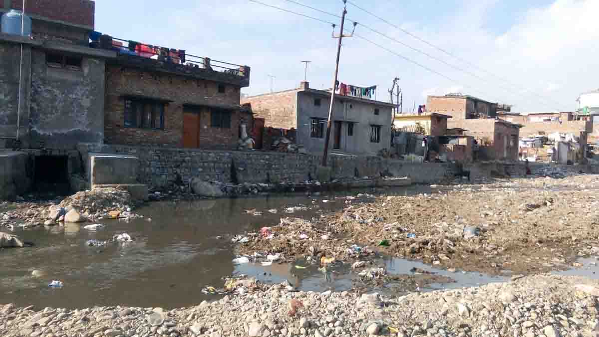
While discussing the pitiable states of major rivers like the Ganga and Yamuna, we often ignore these smaller rivers, the arteries crisscrossing the country, unassumingly performing their functions as agents of nature. India is a country of not only rivers but also rivulets. What is the performance status of small streams and rivulets in India, an important part of the riverine ecosystem? As the readers might have guessed, it is much below par, and many of these valuable geographic entities have disappeared or are on the verge of extinction. The rivulets and streams across the country, from the Himalayan ranges to southern India, have been reduced to drains or sewers due to rapid encroachment, urbanisation, extension of the built environment, and pollution. And, many times, the governments that should be the saviours end up as destroyers. A few examples of rivulets/streams near Dehradun, a city located in the Doon Valley, a wide, long valley within the Siwalik Hills and the Lesser Himalayas, in the state of Uttarakhand, provide us with a broad picture of the ‘rivulet crisis’ of India.
The Rispana and Bindal rivers: A leading newspaper dated April 15, 2025, reports that the Uttarakhand High Court suspended construction activities around the Rispana and Bindal rivers. This directive was issued in response to a hearing on multiple public interest litigations (PILs) concerning encroachment and environmental degradation in the riverine areas of Dehradun and surrounding regions. The report further states that the state government furnished a response, indicating the installation of high mast illumination and CCTV near identified natural water sources of the Rispana and Bindal rivers. Additionally, an awareness campaign is set to be launched to deter debris disposal near water sources. Meanwhile, the municipal corporation informed the court that it had cleared over 1,000 hectares of encroached land in Dehradun, while contractors found disposing of debris in the rivers would face prosecution.
The bench also heard other PILs highlighting the environmental problems arising from large-scale construction on submerged land in Sahastradhara and the unauthorised construction on rivers and slopes in Rishikesh.
A report filed by ANI, dated February 17, 2025, says that the state government intends to start the work on an 11-km-long four-lane elevated corridor that is to be done on the bed of the Rispana river and a 15-km-long highway corridor on the bed of the Bindal river. The project, according to the reports, envisages constructing two elevated highways of a combined length of about 26 km with an estimated cost of over Rs 6000 crores, practically destroying the river courses. Veteran environmentalist, Ravi Chopra, hit the nail when he said: “On the one hand, the state government talks about reviving these water bodies and beautifying the riverfront. On the other hand, it plans elevated roads that will ensure their death. These roads will be in the shadow of the outer Himalayas, marked as highly susceptible to earthquakes, where climate change is also causing intense rains. The experts have flagged these attempts to concretise the riverbed and construct piers on the riverbed that will make the neighbouring areas more prone to flooding. Obstructing the natural flow of rivers will also deplete the groundwater reserves.”
The Mohandrao river: Located in the Siwalik-Terai region, the Mohandrao river of Haridwar district is a dynamic river system with its wide and flat boulder channel. It flows through gorges in the higher Siwalik range and near the town of Mohand. This drainage network is also influenced by the tectonic activity of the Mohand anticline and by climate and lithology. Roorkee is located relatively close to this region, being 30 km from Haridwar. The river’s dynamics, including its wide, flat boulder channel, are significant fluvial features in the Himalayan foothill region. This ephemeral river, which becomes active during monsoons, is also being impacted by the construction of a four-lane road, as part of the Delhi-Dehradun highway. Exposed to lateral stresses from water currents and vertical stresses from the road, constructing road piers in a riverbed presents several potential problems, primarily stemming from river dynamics as the intensity of rainfall increases. The challenges include scouring and undermining of piers. We have witnessed large floods that damaged or destroyed bridges in recent years. Rapid currents can erode the riverbed around piers, leading to scour holes and potentially weakening the foundation, a major cause of bridge failures. The flow of water, sediment transport and seasonal changes (like floods and droughts) can all affect the stability of pier foundations, making them vulnerable to instability and damage. Destroying the river bed would also decrease channel capacity, increasing the flood risk even during moderate flow events and channel avulsion often damaging the buildings of the surrounding areas and agricultural land.
Anwesha Borthakur, currently at the Rachel Carlson Centre in Munich, and Pardeep Singh, currently in the Department of Environmental Studies at PGDAV College, University of Delhi, share some examples of dried-up rivulets in their paper published in Energy, Ecology, Environment in 2016. For instance, the river Bharalu and its rivulet Bahini, which flow through Guwahati in Assam, have been reduced to ‘sewers’ due to unplanned urbanisation. Encroachment and the dumping of solid and liquid waste are degrading the river system. The authors suggest that Guwahati suffers from flooding and pools of stagnant water during the monsoons. A healthy river system of Bharalu-Bahini would have facilitated a balance between inflow and outflow, in addition to serving as a source of potable water and various freshwater fish for the people.
The authors also refer to two tributaries of the Ganga, the Varuna and Assi, flowing through Varanasi. The city of Varanasi gets its name from these streams and is mentioned in Buddhist Jataka stories and the Mahabharata. Both water bodies are becoming sewers that carry untreated sewage and effluents and serve as dumping grounds for solid waste. The survival of these rivers is essential for the future of Varanasi. It is reported that in February 2023, Denmark and the UP government signed a Rs 1,000-crore MoU for cleaning the tributary, Varuna. However, the National Green Tribunal (NGT) has expressed concerns about the slow progress of river restoration. A similar fate awaits the Mula and Mutha rivers flowing through Pune, an expanding urban centre in Maharashtra, due to the release of untreated effluents and large quantities of wastewater.
These examples provide a broad picture of the degradation of the integral parts of the river basins in India. As we have seen, what justifies constructing an elevated highway along the riverbed of an active mountainous stream? Most small streams and rivulets elsewhere in India also confront similar challenges. The fundamental issue is how to minimise human interference in these natural systems so they can maintain a healthy natural flow regime and self-organise. In India, large-scale land-use changes and human activities have altered riverine landscapes. India’s water policy should be reformed, acknowledging that rivulets and streams are dynamic components of the eco-hydrological cycle. The entire river basin, not just the main river trunk, should be regarded as a primary unit of water governance.


Leave a comment