Expert Expressions
We need to protect our geological diversity
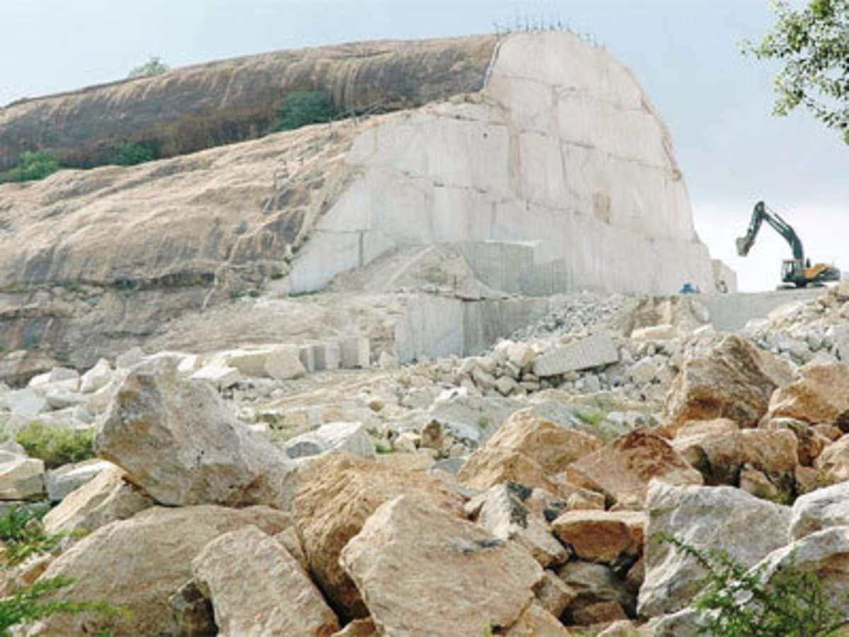
Travelling from Bengaluru International Airport to the city’s downtown, you cannot escape the ugly sight of a billion-year-old granite hillock being vandalised in the name of quarrying. Once a hillock with a panoramic view, it has now been reduced to half its size. This is just one of several cases of regular destruction of India’s geological heritage. The fact that the country accounts for more than 30% of stone production in the world speaks volumes about the magnitude of quarrying and excavation. Apart from marble that dominates the stone production industry, export of what is collectively called granite — the term encompasses diverse suites of metamorphic and igneous rocks — fetches billions in foreign exchange. This industry is unscientifically mined and managed, is generally outside the pale of public scrutiny, and remains unregulated. Weak environmental laws govern it. The area under stone mining operations exceeds more than 10% of the total area of India and if these activities are allowed to go on unchecked, especially in the context of current developmental interests, India’s topography and geological heritage stand to be lost forever. We need sustainable conservation approaches to safeguard our natural geological heritage as has been done in the area of biodiversity.
Non-cultural heritage
Geological diversity includes rocks, minerals, fossils, and landscapes that have evolved over billions of years. India’s tumultuous geological past is recorded in its rocks and landscapes and should be considered as our non-cultural heritage. Unfortunately, geological conservation is an ignored subject in the country. Geological features that should be declared as national assets include bodies of unusual rock types, landforms that preserve records of natural events of the past, significant fossil localities, stratigraphic type sections, areas where significant advances in geology have been made, and deposits of particular minerals. For example, the now-defunct Kolar gold mines should be developed into a geological museum with an educational outreach unit for students. Indian geo-diversity can boast of the world’s greatest mountain peaks, coral reef islands, coastal dunes, and large inland waterbodies and wetlands. A variety of rocks, minerals, and distinctive fossil assemblages can be found in a number of places. For instance, Kutch in Gujarat and its vicinity contain dinosaurian fossils of the Mesozoic age (200 million years), but many geological sections in that region are lost forever due to construction of highways and real estate development. It is ironic that while on the one hand we aim to go to Mars in search of evidence of early life, on the other, we destroy in our own backyard precious evidence of early life.
Japan offers a good lesson in conservation of geo-diversity. The Kobe earthquake memorial park preserves a section of the fault line (around 150m) which ruptured during the 1995 disaster through the town of Hokudan. The 1993 earthquake in Latur, Maharashtra, had also generated a vertical ground rupture of 1m near Killari town, but I doubt we have ever considered creating an earthquake memorial park around this feature, or a suitable memorial in the areas affected by the 2004 tsunami. The collective memory of such natural tragedies reinforced through such efforts will prepare communities over generations to meet such eventualities. Memories help us to have existential reconstructions — a means by which people make sense of their lives. The Geological Survey of India is the agency entrusted with the protection of geological features. Its website suggests that more than 26 sites have been selected as part of its commitment to preserve them for posterity. However, we are yet to see a concerted strategy from officials to do this. A major challenge for Indian geologists is the creation of a complete inventory of geological structures in the country and to ensure that all government plans take full account of the country’s geological heritage. Educational outreach programmes about these treasures need to be organised for officials and politicians. Most importantly, we need to evolve practical mechanisms to ensure that our geological heritage survives in the long term. Geo-conservation should be a major factor in land use planning, and a stringent legal framework needs to be evolved to support such conservation strategies. Our history does not begin at Harappa and Mohenjo-daro; it goes back a billion years.
Rajamala landslip tragedy should open our eyes
Kerala has to come up with bold imaginative, but humane, initiatives on environmental land management and new utilisation rules for land and water while maintaining the sustainability of drainage basins considering all related uncertainties. Land use zoning regulation that incorporates landslide susceptibility data should be made mandatory. The data that is made available by the agencies like the Geological Survey of India indicates that out of the approximately 39,000 square km area of Kerala, the hill area having slopes higher than 10 degree constitutes about 19,000 square km and most of the scarps are thinly forested and further weakened by human activities.
I don’t think there is any dearth of scientific data on landslide vulnerability in the state although some specific geotechnical and geological studies may be required in some areas. To my knowledge, several detailed technical reports have been submitted to the State Government at various times. It is high time that we came up with a program that would enable us to use such data to mitigate the hazard,” he said. It is important that both the local and state authorities should be relying on scientific reports on the landslide vulnerabilities to reach decisions on land allocations for various constructions in the hilly districts of Idukki and Wayanad. In these decisions, local soil properties and slope stability should be important factors to be considered, rather than political expediency. A blueprint that demarcates areas suitable for habitation and those to be left untouched should help in strict implementation of basic tenets of land zonation. Drafting a comprehensive master plan on land utilisation strategy based on a clear environmental vision at macro and micro-levels to ensure that encroachment is minimal. These documents should contain clear guidelines for constructions, including recommended designs of houses that will match with local landscape and scenery. As far as landslips near Rajamala are concerned, it is not clear if this particular locality has been identified as a landslide prone area in any previous studies. But the fact is, since 2018, Kerala has been witnessing unusually high rainfall that has destabilised the already vulnerable hill slopes in the high ranges of the state. Some of them that may not have seen landslides in the past are now become potentially vulnerable to heavy sliding.


Leave a comment