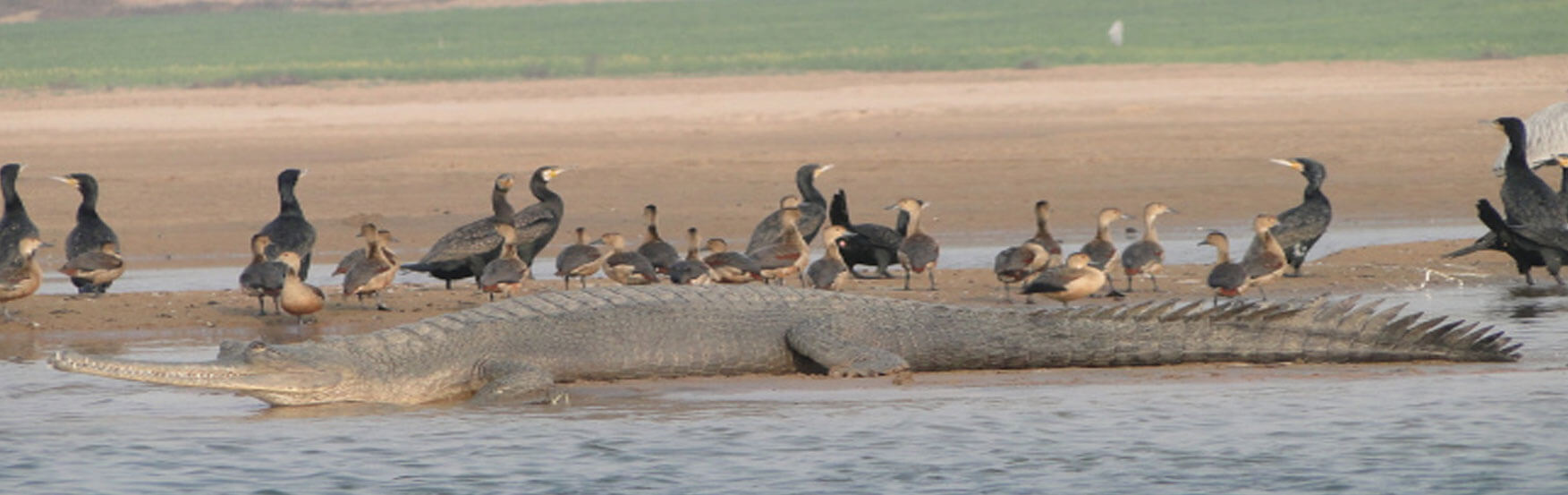
The Ken-Betwa Link Project is the first project under the National Perspective Plan for interlinking of rivers. Under this project, water from the ‘supposedly’ surplus Ken will be transferred to the deficient Betwa. Both these rivers are tributaries of River Yamuna. The project aims to fulfil the water needs of drought-prone Bundelkhand region. However, questions are being raised over its ecological impact as the destruction that this project will wreak is clearer now: 9,000 ha of submergence- most of it in the Panna Tiger Reserve. It will include the felling of 23 lakh trees with a girth of 20 cm or more. The key wildlife species that will be affected include tigers, endangered vultures, mahseer fish and ghariyals in the Ken Ghariyal Sanctuary. Is the project worth it? Find out in this detailed report...
Himanshi Shukla
A Memorandum of Agreement (MoA) was signed between the minister in charge of Jal Shakti ministry, Gajendra Singh Shekhawat, Chief Minister of Uttar Pradesh Yogi Adityanath and Madhya Pradesh CM Shivraj Singh Chauhan on March 22- the World Water Day. The agreement, which was carried out via video conferencing in which the PM too participated, stamped the much hyped and much awaited Ken Betwa River Interlinking project. The Ken-Betwa Link Project (KBLP) is the first project under the National Perspective Plan for interlinking of rivers. Under this project, water from the ‘supposedly’ surplus Ken River will be transferred to the deficient Betwa River. Both these rivers are tributaries of River Yamuna. The project aims to fulfil the water needs of the drought-prone Bundelkhand region. As per the comprehensive Detailed Project Report by the National Water Development Authority, the cost of Ken-Betwa Link Project is estimated at a whopping Rs 35,111.24 crore.
What does the project entail?
The Ken-Betwa Link Project has two phases. Under the first Phase (KBLP-1), one of the components — Daudhan dam complex and its appurtenances like Low Level Tunnel, High Level Tunnel, Ken-Betwa link canal and Power houses — will be completed. While in the second phase (KBLP-2), three components — Lower Orr dam, Bina complex project and Kotha barrage — will be constructed.
Anubhav Dwivedi, MTech- Structural Engineer and Assistant Professor, AKTU- SR Group, states: “The Ken Betwa Project (KPB) is located in the Bundelkhand region of Madhya Pradesh and Uttar Pradesh in India. The project envisages the construction of a dam at Daudhan, a location upstream of the Periccha Weir in the Ken River, and then, will divert the Ken River water from this reservoir through a canal to the Betwa River. The project has three irrigation components. It proposes to provide irrigation to:
• en route command area of the link canal
• downstream area of the Ken River and
• transfer water to downstream areas of the Betwa River by substituting the irrigation demand of the upper reaches of the Betwa River.
Seven districts in Bundelkhand region cover the KBP command area. The en route command of the link canal falls inside Tikamgarh and Chhatarpur districts in Madhya Pradesh and Jhansi and Hamirpur in Uttar Pradesh. The Ken Multi-Purpose Project (KMPP), proposed previously by the Government of Madya Pradesh, falls inside Chattarpur and Panna districts in Madhya Pradesh. The Betwa command, which consists of four projects namely, Barari, Richhan, Neemkheda and Kesari, is located in the Raisen and Vidisha districts in Madya Pradesh.”
What benefits does the project seek to provide?
As per the Jal Shakti Ministry, the project is expected to provide annual irrigation of 10.62 lakh hectares, drinking water supply to about 62 lakh people and will also generate 103 MW of hydropower. According to the Jal Shakti Ministry, the project will be of immense benefit to the water-starved region of Bundelkhand, especially in the districts of Panna, Tikamgarh, Chhatarpur, Sagar, Damoh, Datia, Vidisha, Shivpuri and Raisen of Madhya Pradesh and Banda, Mahoba, Jhansi and Lalitpur of Uttar Pradesh. “It will pave the way for more interlinking of river projects to ensure that scarcity of water does not become an inhibitor for development in the country,” the Ministry said in a statement.
As per the Feasibility Report of the National Water Development Authority, “The reservoir will irrigate an area of 3.70 lakh ha by the direct irrigation and provide water to drought prone areas of Upper Betwa sub basin by way of substitution to 1.27 lakh ha annually. Besides this, the project will provide 850 Mcum of water to U.P. to utilize in the downstream areas of the proposed KMPP. The ultimate benefits going to be accrued from the project will go to the states of M.P. and U.P. The total installed capacities of the power houses proposed under the project are 72 MW.”
Talking about the employment opportunities the project seeks to create through pisciculture, the report states, “A wide range of indigenous fishes are found in the Ken river. They are Rahu, Bhadur, Mrigal, Tingar, Singahi, Mangur, Pawda, Baam, Sooja, Sinni and Mahasir. Creation of the Daudhan reservoir shall-definitely increase the production rate of all the varieties of fishes found in the area. In addition to this some other improved varieties of fishes like Catla, Common Carp, Kariyat, Mrigal etc. can be cultured very easily. The Pisciculture development proposed to be created in the project area will also provide additional work to the local fishermen and revenue to the governments.”
The report goes on to state a number of other benefits, the most dazzling of which is the ability of the Dhaudhan Dam to mitigate impact of floods- “It will also provide about 12 Mm3 of water for drinking purpose to the en route areas of the link canal. As the FRL of the proposed Daudhan reservoir has been fixed at 287.0m, which is about 52.0 m above the present FRL of the existing Gangau weir. It is therefore, seen that the storage of Daudhan dam will definitely contribute its own role in mitigating floods in the downstream portion of Ken basin to a greater extent. At present there is no industrial unit has been set up in the area. However, due to coming up of such a multipurpose project in the area may encourage setting up of some medium and small-scale industrial units in and around the project area and will be helpful for the overall development of the area economically.”
What does the project entail for the Panna Tiger Reserve and the adjoining wildlife habitats?
As stated by Minister of State for Jal Shakti Rattan Lal Kataria, in a written reply to Lok Sabha, out of the 6,017 ha of forest area coming under submergence of Daudhan dam of Ken Betwa Link Project, 4,206 ha of area lies within the core tiger habitat of Panna Tiger Reserve.
As per the comprehensive Detailed Project Report, the total annual irrigation under the KBLP is 9.04 lakh ha comprising of 6.53 lakh ha in Madhya Pradesh and 2.51 lakh ha in Uttar Pradesh. Out of the 6017 ha of forest area coming under submergence of Daudhan dam of KBLP, 4206 ha of area lies within the core tiger habitat of Panna Tiger Reserve.
Himanshu Thakkar, coordinator of the South Asia Network on Dams, Rivers and People, states: “The current cost of the Ken-Betwa project is Rs 38,000 crore, and the contours of the ecological destruction that the project will wreak are clearer now: 9,000 ha of submergence, most of it in the Panna Tiger Reserve. This would include the felling of 23 lakh trees with a girth of 20 cm or more. The key wildlife species that will be affected include tigers, endangered vultures, mahseer fish, and ghariyals in the Ken Ghariyal Sanctuary.”
The Central Empowered Committee of the Supreme Court had noted in August 2019: “the availability of corridor in Panna Tiger Reserve for movement of animals from east to west and vice versa every year after the month of October will not be the same after the construction of Daudhan Dam because the dead storage level in the reservoir even at the peak of summer is proposed to be retained at a minimum of 240 m which is much higher than the present river level of 216 m at dam site. This has a serious implication because at 24O m dead storage level the portion of the river where the gradient is gentle will always remain under water. The DPR has projected that at 241 m total area under submergence will be 2550 ha. The River Ken from Ghairighat downwards flows through deep gorges and exposure of the gorge section of the river during summer months even after decrease in water level in the reservoir will not help animal movement across the river because of steep gorges. In short, the animals will not be in a position to use a major part of the River Ken for crossing from east to west or vice versa even during peak summer.”
The CEC Report also points out to the possible destruction of Ghariyal Sanctuary and Aquatic life in the Ken River, “During the monsoon flow of water with silt is essential for survival of the Ghariyal Sanctuary located downstream of proposed Daudhan Dam. The ecological flow of water from the dam will not be carrying any silt because the water which is being released downstream is only after sedimentation of the silt within the reservoir. The massive engineering structure of the dam is bound to isolate the upstream aquatic fauna of the Panna National Park and this may have direct impact on the breeding habits of aquatic life forms both upstream and downstream of the dam. The construction of the dam will result in the reservoir area transforming itself into a depositing substratum and which in turn will result in drastic conversion of aquatic habitat thereby changing the whole ecosystem within the Panna National Park as well as downstream of dam. This situation may lead to extinction of many aquatic forms of life.”
“The Panna National Park (PNP) was constituted principally considering the unique geomorphologic speciality of the location like the gorges, caves, cliffs along Ken River and its tributaries and the riverine vegetation in the valley which provide much needed cover to different wild animals including tigers in shaded space of trees, shrubs and grasses and also to varied reptiles and birds. This part of PNP is the signature landmark of the Park and if the Daudhan Dam is commissioned this unique ecosystem of the Park which is the identity of PNP will be irrecoverably lost forever. Most of the important geological sites are going to be affected either by submergence upstream of the proposed dam or would dry up when the full flow of river is arrested by the proposed dam. No amount of mitigative measures can create this kind of unique ecosystem which has evolved over millions of years to reach the present level of biodiversity. The very purpose of the legislation to declare any area of such ecological and evolutionary significance as National Park will be totally defeated if the recommendation of SC NBWL is accepted in the present form,” the CEC report states.
However, the Feasibility Report of the National Water Development Authority states otherwise, “The impact of the submergence on the wild life of the park will be nil, as the area coming under submergence is only about 9% of the total area of the national park and the wild life has got its own natural characteristic of moving to the interior forest areas adjacent to the areas of submergence of the project area. However, adequate remedial measures have to be adopted for covering the biodiversity impacts on the endangered species of flora and fauna of the sensitive area, starting right away from the planning phase to implementation stage followed by management level.”
How will the public life be impacted?
As per Anubhav Dwivedi: “According to the Socio-Economic Survey, a total of 6,380.67 ha of patta land has to be acquired in respect of Daudhan reservoir for submergence (2171.00 ha), K-B Link Canal (2492.32 ha), Ken LBC (1706.36 ha), and Power Houses at Daudhan (11.00 ha). In addition, about 37.95 ha of land for township and 4.0 ha of land for green belt development may be required. Thus, the total land acquisition required for the project is estimated to be 6,422.62 ha. The cost of relief, resettlement and rehabilitation of the affected households under the Ken Betwa Link Project Phase-I has been worked out in the accordance with provisions of the Right to Fair Compensation and Transparency in Land Acquisition, Rehabilitation and Resettlement Act 2013. Broadly, the issue has two major components namely i) land compensation; ii) resettlement and economic rehabilitation of PAFs. The total compensation for land acquisition is estimated to be Rs 1,007.07 crore. The total geographical area of the 10 villages affected due to Daudhan reservoir based on RS imageries and GIS analysis is 9000 ha. About 24.12 per cent of the area is sown with agricultural crops.”
In a personal account, Himanshu Thakkar recalls the people’s reaction to the project way back in 2008. “I was part of an expert committee on the Interlinking of Rivers (ILR) programme, constituted by the Union Ministry of Water Resources in 2005-06, on my way to talk to the people of Daudhan village in Chhatarpur district, through which the Ken River flows. I did not anticipate the storm of spirited opposition that hit us from the people of Daudhan village, which is located close to the proposed Greater Gangau Dam site, the main dam that would facilitate the proposed Ken-Betwa Link Project through a 230 km long canal. Ten villages, including Daudhan, were expected to be submerged, with over 10,000 people displaced. No one expected the people of Daudhan to know about our visit. But they did, and the atmosphere at the meeting was charged. An elderly woman, Dadi, made it abundantly clear that they wouldn’t leave their village, come what may. Everyone at the meeting was vehemently opposed to the project. A memorandum in Hindi, submitted by the people of Daudhan village, read thus: “The whole village is against displacement to another place. We have clean water, air, forests and land for agriculture, which won’t be available to us at a new place. All of us want basic facilities like electricity, roads, schools and health facilities, so we can enjoy a basic standard of living. So, instead of displacing us, kindly help us get these basic facilities.” We received about a dozen memorandums during the visit.”
The Feasibility report of the National Water Development Authority states: “The villagers along the periphery of the reservoir will face the problem of waste water disposal as the existing drains will become inefficient due to the impoundment of water in the reservoir in their vicinity. Proper drainage system is, therefore, to be designed for the villages to minimise the adverse effects. Although no important road will be submerged yet the dry season motorable road measuring about 30 km in length from Gangau to Palkohan- Sukwaha-Bhorkhowa-Basudha-Shahpura will get submerged. When the project will be taken up for construction, there may be increased chances of mosquito genic conditions. Increased mosquito breeding places due to quarrying will result in increased output of vector mosquitoes. Changed humidity and temperature conditions due to extensive water sheets will make it more conducive to greater transmission potential throughout the year. To deal with the problems, it is necessary to inform the labours and other personals engaged in the various works of the project and introduce anti-malaria measures like distribution of oral medicines and mosquito nets, educating the people for maintaining hygienic living conditions etc. at the construction stages followed by management phases and to be implemented in the field by the project authority with the co-operation and guidance of National Malaria Eradication Programme Authorities.”
Where does the opposition to the project stem from?
Himanshu Thakkar states: “The Supreme Court-appointed Central Empowered Committee (CEC), in a most remarkable report of August 30, 2019, had raised fundamental questions not only on the appropriateness of the wildlife clearance given to the project, but also the viability, optimality and desirability of the project. The detailed project report of KBLP prepared by the project proponent National Water Development Agency (NWDA) says: “The main objective of the Ken-Betwa link project is to make available water to water-deficit areas of the upper Betwa basin…” However, the upper Betwa region is outside the Bundelkhand and has higher rainfall than the region. Most areas of Bundelkhand that have been promised water are already being supplied by existing projects. There is a great scope for improving the water availability in Bundelkhand from existing resources and projects, which can be achieved faster and much cheaper. Both the forest advisory committee (FAC) and the CEC conclude that the NWDA has not examined the alternatives to the project. The Panna district, one of the least irrigated areas of Madhya Pradesh, will, on the other hand, suffer maximum destruction, while getting very little benefit from the project. Downstream, Uttar Pradesh’s Banda district too stands to suffer adverse impacts that have been flagged by state officials.”
Another premise on which the project is being approached is the false notion that Ken river has surplus water. Mr. Himanshu Thakkar points out: “The project is based on the premise that the Ken, the smaller of the two rivers, has surplus water. But the hydrological data that is claimed to support that premise is not in public domain, and has never been put to scrutiny by any independent credible agency. In this context, the FAC made a suggestion that has never been implemented: “A team of independent experts on surface water hydrology, drawn from leading scientific institutions, should have been requested to examine the hydrological aspects of the Ken-Betwa river link.” The CEC report raises the question about the neglected water needs of the Upper Ken basin, a tribal area which this project is likely to keep permanently backward. Moreover, the KBLP does not have the final forest clearance, and its wildlife clearance has been opposed by the SC-empowered CEC. A challenge to its environment clearance is pending before the National Green Tribunal.
The Central Empowered Committee report of the Supreme Court questions the assumptions of water availability for the project: “The catchment areas of River Ken and River Betwa on an average receive about 90 cm of rainfall only. This has a serious implication because during drought years the availability of water in both the river basins may be much less than what has been projected in the various studies. What is more the commitment of entire water available from River Ken, through KBLP Phase l to develop Ken Lower Basin and Upper Betwa basin in future is bound to deprive the farmers in Upper Ken Basin/ catchment area even to go in for minor irrigation projects. Therefore, the projection of availability of surplus water in Ken Basin for transfer to Betwa Basin without first exhausting possibilities for development of irrigation facilities in Upper Ken basin appears to be premature particularly considering that an investment of Rs 28,000 crore of public funds is involved.”
Anubhav Dwivedi states: “Apart from many positives such as value-added direct crop production and livestock benefits, the KBLP also has many critiques- such as inadequate attention has been given to cropping patterns and their suitability to the region which can trump the agricultural benefits. Moreover, the Inadequacy of the project planning to meet different scenarios of future water resources development needs should be questioned as far as possible. Also, there were inadequate water balance studies and a lack of participation of local people in the decision-making process of project planning. Moreover, the failure to utilize the existing infrastructure to its optimum or of alternative options analysis is something to discuss. So, in my opinion, there are not enough benefits to outweigh the cost.”
The Flip Side: Water Scarcity or Unrealised Potential?
Mention we must the Central Empowered Committee of the Supreme court which had outrightly dismissed the claims of the Feasibility Report of NWDA. As Himanshu Thakkar points out: “The CEC report also shows that large proportion of the claimed benefits of the KBLP-I are not additional; they are already available without the project: “However when one analyses the projected figures of irrigation it will be seen that the existing area under irrigation using water from River Ken through Bariyarpur PUW (ii) in Uttar Pradesh is 2.14 lakh ha out of the 2.52 lakh ha proposed under KBL. The net increase in the area with the implementation of KBLP is therefore only 0.38 lakh ha in the State of UP. Similarly, the State of M.P. is yet to fully utilize the share of water from the River Ken through Bariyarpur PUW though MP has a share of 398.22 MCM of water with a projected Command area of 68356 ha in the State. Moreover, the list of 182 irrigation projects in Ken Basin and 348 irrigation projects in Betwa basin along with irrigated area and water utilization provided in the CEC report annexures show that there is a huge scope for improvement irrigation efficiency in these schemes, without going for new massive project like KBLP-I, CEC report notes.”
“The CEC report goes on to say that UP is demanding more water from the project, which remain unsettled: “(a) The State of Uttar Pradesh in their response filed before the CEC has claimed 50% share
i) of 659 MCM of water to be transferred to Betwa basin, as per the inter-governmental agreement, and
ii) of the 402 MCM additional water yield assessed as per the NWDA study of 2010.
(b) In this way the total additional share of water claimed by the Government of Uttar Pradesh is 530.5 (659/2 MCM + 402/2 MCM). Since as per the Detailed Project Report the quantity of water to be used at Upper Betwa basin on substitution basis is 384 MCM (DPR Vol. lll – Hydrology) and if the above claim of the State of Uttar Pradesh is to be admitted then in that case no water will be available for development of irrigation in Phase ll in the Upper Betwa region. This demand of Uttar Pradesh when read with the lesser availability of water as assessed in studies prior to 2010 (refer para 15 above) raises serious doubts with regard to the availability of surplus water in Ken basin for transfer to Betwa basin. In such a scenario inclusion of the KBLP Phase I as a river linking project is self-defeating.”
Alternatives to the project not thoroughly examined
Himanshu Thakkar quotes from the CEC report: “The primary objective of the KBLP of providing irrigation facilities and alleviating poverty can be achieved through alternative method of water conservation/harvesting at local level and that too at much cheaper cost. For instance, providing more efficient system of irrigation such as drip irrigation and resorting to less water demanding crops like millets and horticultural crops (fruits and vegetables) rather than increasing the area under high water demanding crops like wheat, paddy and sugarcane will lead to a reduction in the demand for water for irrigation purposes and simultaneously water can be made available to larger area than what is envisaged under KBLP. To a query made by CEC on the scope of utilising more efficient technologies relating to irrigation such as employing micro irrigation system and suitable crop planning suited to the agroclimatic conditions prevalent in the arid command area the NWDA while admitting that micro/drip irrigation saves water and fertilizers informed CEC that the micro/drip irrigation system is suitable for crops including grapes, banana, pomegranate, orange, citrus and mango. These crops are very rarely grown in practice in Bundelkhand region. Therefore, this system may not be suitable for the area. This statement of NWDA only goes to confirm that the alternatives to mega Hydel Project have not been examined by the project proponents.”
Emphasizing that better options exist, the CEC goes on to say: “The uncertain rainfall pattern and reduced flow of water should force the planners to encourage the farmers to revisit the tradition and opt for crops such as pulses and horticulture produce. Construction of check dams along the course of the rivers and other soil and water conservation measures can rejuvenate the aquifers. This approach is likely to improve agricultural productivity in a much larger area at lesser cost per unit area.”
The Way Forward
Commenting on the issue, Anuj Kumar Saxena, ex-IFS, says: “The project, though ambitious has a questionable feasibility. It is anti-nature to begin with. Let it be remembered that it is a plateau region and there are limits to how much the flow of the water can be controlled. It would be wiser to adopt methods that support best utilization of water available – the classic rainwater harvesting method is a case in point. Moreover, development should be done keeping in mind the future consequences- water flow may become so high that it can’t even be utilised or even massive floods. The question at hand- the water problem of the Bundelkhand region must be resolved and at present, it seems that the river linking isn’t the best possible solution.” Himanshu Thakkar is of the opinion that the recommendations of the CEC must be accepted by the government and due process must be followed in getting proper Environment Impact Assessment. Anubhav Dwivedi states: “Ken Betwa interlinking project can act as a boon to the water scarce districts of the Bundelkhand region where farmers are struggling with their dependency over monsoon. This can even boost the agricultural production of the area by including water intensive, plantation and cash crops in their crop cycle that will increase the income of farmers. Project will also curb the long pending problems of drinking water and electricity. But government cannot avoid the huge Environmental, Social and Economic cost 3/4 involved with the project. Hence, before proceeding with the final approval of the project, government should comprehensively consider the social impact assessment, which involves proper rehabilitation of displaced people including their employment, and wages compensation.”


.jpg?resize=780%2C450&ssl=1)


Leave a comment