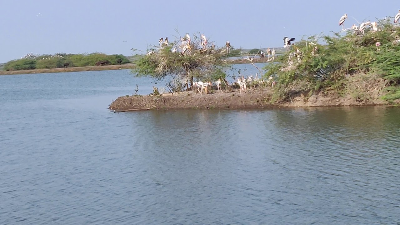
A Ramsar Site is a wetland site designated to be of international importance. These wetlands are protected under strict guidelines of the Ramsar Convention on Wetlands. The Ramsar Convention on Wetlands, also known as the Convention on Wetlands, is an intergovernmental treaty for the conservation and wise use of wetlands, signed in 1971 by UNESCO in the Iranian city of Ramsar, and is one of the oldest inter-governmental accords for preserving the ecological character of wetlands. Over 170 countries are now party to the Ramsar Convention. There are over 2,400 Ramsar Sites around the world covering over 2.5 million square kilometres. In the second half of 2019, 10 additional wetlands of India have been recognized as Ramsar sites taking the total tally of such wetlands from 27 to 37. But, just getting Ramsar tags really help the cause of wetlands protection? Here we try to show the present conditions and threats the Ramsar wetlands sites are facing today…
AK Singh & Arunima SenGupta
Ramsar Wetlands in Crisis: North India
Interestingly 20 of the 37 Ramsar wetland sites, i.e., over half the Ramsar sites of India are located in North India. These are situated in states Punjab (6), Himachal Pradesh (3), Uttar Pradesh (7) and union territories (UT) of Jammu & Kashmir (3) and Ladakh (1). The remaining states of Uttarakhand, Haryana, Delhi and UT of Chandigarh have no Ramsar sites.
Six more sites in the Uttar Pradesh have been declared as Ramsar sites in 2019, taking the total tally in the state to seven. Earlier Uttar Pradesh had only one Ramsar site which was 265.90 sq km area of Upper Ganga River from Brijghat, Garh Mukteshwar to Narora in Bulandshahr stretch which was declared a Ramsar site in August 2005. The six new sites added to Ramsar list are 2.25 sq km area of Nawabganj Bird Sanctuary in Unnao (Sept 19, 2019), 7.22 sqkm of Parvati Agra Bird Sanctuary in Agra (Dec 2, 2019), 5.26 sq km are of Saman Bird Sanctuary in Mainpuri (Dec 2, 2019), 7.99 sq km area of Samastipur Bird Sanctuary in Rae Bareli district (Sept 26, 2019), 3.09 sq km area of Sandi Bird Sanctuary in Hardoi (Sept 26, 2019) and 1.61sq km area of Sarsai Nawar Jheel in Etawah district (Sept 19, 2019).
The 85 km long river stretch of Upper Ganga and 2,073 sq km Hastinapur wildlife sanctuary covering parts of five districts of Bijnor, Meerut, Hapur, Amroha and Muzaffarnagar forms important habitat for the dolphin population in the river. On January 16, 2020, a dead body of an adult dolphin with deep injury by harpoon, was found near Jalalpur Jora village in protected Hastinapur wildlife sanctuary. The post-mortem report revealed that the harpoon had hit the spine of the mammal leading to death. In October 2019 in dolphin survey by forest department and WWF 36 dolphins were counted in this river stretch. Now the number has come down to 35. The incident shows loop holes in conservation measures as the area is earmarked exclusively for dolphin conservation. The site has also been included among 130 sites across the country by union environment ministry for protection on priority basis. As per the report, the dolphins are facing threats from poaching for oil and pollution in the river. Nawabganj Bird Sanctuary established in 1984 in Unnao, has a 90-ha pond which is fed by Sharda canal. While Garra river supplies water to the 214-ha pond in Sandi Bird Sanctuary which was established in 1990 in Hardoi. Over the years the natural water sources comprising river catchment and rain water had either dried up or did not supply enough water to feed the ponds at these bird sanctuaries. Consequently, the number of migratory birds taking refuge in the two reserves had declined. As per a January 2017 report, under endangered species project of the forest department had to install three tube wells to keep the ponds alive as a permanent solution. The department was shockingly terming it successful effort and was reportedly working on the possibility of installing solar pumps. The Sandi wetlands also locally known as Dahar Jheel spread over 300 ha is important location for migratory birds. It is hardly 20 km away from district headquarters. As per locals it had natural water sources including rain water and Gira river water, but for many years rainfall had decreased turning the lake dry and hence birds have also stopped visiting the area.
There is not much data available to reveal the present-day status and threats on the wetlands. The Ramsar website mentions this about the water body: “Parvati Arga Bird Sanctuary is a permanent freshwater environment consisting of two oxbow lakes. These wetlands are characteristic of Uttar Pradesh and offer exceptional habitats for waterbirds, providing both roosting and breeding sites with over 100,000 birds documented in annual counts. The Sanctuary is a refuge for some of India’s threatened vulture species: the critically endangered white-rumped vulture (Gyps bengalensis) and Indian vulture (Gyps indicus), and the endangered Egyptian vulture (Neophron percnopterus) have all been recorded. It is also critical in the maintenance of hydrological regimes, ensuring groundwater recharge and discharge. Meanwhile ancient temples around the lakes provide religious significance and encourage tourism. Invasive species such as the common water hyacinth (Eichhornia crassipes) along with the development of roads and railways present significant threats. The Uttar Pradesh Divisional Forest Officer and Chief Conservator of Forests along with Sanctuary Officers share management duties. The Sanctuary is located in the state of Uttar Pradesh, Tarabganj Tehsil, at a distance of about 40 km from Gonda District at Mankapur-Nawabganj Road.”
Saman Bird Sanctuary is spread over an area of 5 sq km are in Mainpuri district. It was established in 1990. In May 2019, there was a fire incident in the sanctuary area creating threats for the bird population. The Samastipur Bird Sanctuary was established in 1987 and is spread over 780 ha in Salon of Rae Bareli district. The wetland is important habitat for migratory and native birds. However, the wetland is facing regular fish deaths and water hyacinth problems for long time. There is not much report on Sarsai Nawar Jheel in Etawah. The google earth images show that the lake is facing water scarcity.
Punjab has six Ramsar sites which includes 41 sq km area of Harike lake (declared Ramsar site on March 23, 1990), 1.83 sq km area of Kanjli lake (Jan 22, 2002), 13.65 sq km area of Ropar Lake (Jan 22, 2002), 64.29 sq km area of Beas Conservation reserve (Sept 26, 2019), 1.16 sq km area of Nangal Wildlife Sanctuary (Sept 26, 2019) and 3.44 sq km area of Keshopur Miami Chham (Sept 26, 2019). As per experts, wetlands in the state have been drained and transformed by anthropogenic activities like unplanned urban and agricultural development, industrial sites, constructions, impoundment, resource extraction, and dredge disposal causing substantial long-term ecological loss. They also said that the state has already lost 35 per cent of wetlands in the last 35 years due to anthropogenic activities mentioned above.
The Harike wetlands has seen 26 per cent fall in migratory birds’ number in January 2020 comparing to 2019. Climate change, disturbing human activities and dense smoke from stubble burning are cited as reasons behind this. The lake was put on high alert following a bird flu threat in November 2019. It was believed that underwater suffocation in the Sutlej, which gets polluted with industrial waste after passing through Ludhiana, caused the death of the rare species. The man made Kanjli wetlands, a habitat of Ghariyal, is also facing increasing pollution, siltation and decreasing fresh water flows despite high religious sanctity accorded to the Kali Bein which is part of the wetlands. As per the latest report, the native biodiversity and survival of the Kanjli wetland is under threat. The smallest and most neglected among six Ramsar sites in the state, the wetland is threatened by 16 invasive species (alien) of plants as found in research conducted by Bageshwer Singh, a student of forestry. The summer-monsoon monitoring in 2019 in the Ropar Wetland Conservation Reserve recorded only 51 bird species diversity out of recorded total 127 species in the five years’ survey cum monitoring exercise. Similarly, in Nangal wildlife sanctuary, the summer-monsoon 2019 monitoring recorded 60 bird species diversity out of total 134 species recorded during five years seasonal survey. The Keshopur wetland is also known as Keshopur-Miani Community Reserve or ‘Chhamb’ in local Punjabi dialect. It is one of the Asia’s biggest wetlands, located in the middle of the Ravi and Beas rivers in Gurdaspur. The 850-acre marsh area was declared as country’s first notified community reserve following a Punjab Government Notification on June 25, 2007. Keshopur Chhamb was renamed Keshopur Chhamb Community Reserve in March 2013 after the wildlife department decided to develop it as a bird sanctuary. Like other wetlands in the state, the Keshopur Chhamb has also been recording fall in the number of migratory birds. As per the annual bird census conducted on January 11-12, 2020, a total number of 20,528 birds have visited the wetlands against 22,500 last year.
The Beas River provides habitat to critically endangered Indus River Dolphins and Ghariyals. The government in 2019 has declared the Beas as Heritage River and also proposed Beas Conservation Reserve for Ramsar site. The Beas River suffers from lack of fresh flowing water due to the Pong dam built upstream. In March 2018, the aquatic life in the Beas River was under serious threat due to extreme shortage of water. The flow in the river fell after a decision of the Bhakra Beas Management Board (BBMB) limiting water release. While doing so the BBMB gave no thought to water needs of aquatic life in river and at Harike wetland. The report mentioned of Ghariyals moving upstream to deal with the scarcity. Secondly the industrial and domestic waste are being discharged in the river without treatment. In one of the worst industrial disasters, around ten thousand kilo litres of molasses got leaked into the river in May 2018 severely affecting the aquatic eco-system.
The 120 sq km area of Tsomoriri lake was given the Ramsar recognition in August 2002. The wetlands including Tsomoriri lake in Ladakh provide breeding ground to the black-necked crane bird, listed as an endangered species in the state. The bird is believed to be incarnation of Lord Buddha and holds religious significance for Buddhists. However, the bird is now facing serious threats from hunting, stray dogs and irresponsible human interventions being introduced in the name of tourism particularly the bike and motor rallies. The Tsomoriri and Tsokar wetlands, surrounded by marshes and meadows, in Changthang are very important breeding sites for waterfowls and represent the only breeding ground of the bar-headed goose (Anser indicus) and the vulnerable black-necked crane (Grus nigricollis) outside China. Ladakh’s wetlands are already reeling under tourism pressure. The Chandra Taal, known as Moon Lake due to its crescent shaped basin is a lake in the Spiti part of the Lahul and Spiti district in Himachal Pradesh. The lake originates at an altitude of about 4,300 metres and is a source of Chandra River also known as Chenab. The water body has no visible source and gets water from underground. The lake is facing problems from road construction work that is being constructed to boost tourism. In June 2019, the Lahaul-Spiti administration decided to open the lake to tourists from the Spiti side also. Tourists had to reach towards the Spiti valley via the Kinnaur side in summer season as the Kunzum Pass on the Manali-Kaza road remained closed from the Manali side due to annual heavy snowfall during winter season every year cutting off the Spiti residents from Manali and Lahaul for more than eight months. The explosion of tourism is adversely affecting the ecologically sensitive areas in the state. In July 2019, the local panchayat had to ban setting up of camps near the lake area in Spiti to save the ecology of Chandertal Lake. The lake is visited by a large number of people between June and September. According to Anju Shashni, Pradhan of Koksar panchayat, the panchayat had decided that no person would be allowed to set up camps beyond Batal toward Chandra Taal Lake and heavy penalty will be imposed on offenders if they violated the directions.
The 156.62 sq km man-made lake of Pong dam which has ecologically destroyed the Beas River has also been declared a Ramsar site on Aug 19, 2002. Shockingly, even after five decades, more than 8000 families displaced due to the construction of the dam have not been rehabilitated. Giving global recognition to such disastrous projects by the Ramsar convention is sheer injustice to the river eco-system and insult of affected people. Similarly, the Indian government has been pushing a dam on Giri river near the Renuka jheel (lake) which has also been declared a Ramsar site. For years, the lake is facing siltation and pollution problems. Solid waste in large amount also enters the lake area. As per a study by Wadia Institute of Himalayan Geology in Dehradun, the depth and area of the lake has shrunken considerably.
The two Ramsar wetlands sites in Jammu are Wular lake and Hokersar wetlands. The 189 square kilometre (sq km) area of Wular and 41 sq km area of Hokersar wetlands were declared Ramsar sites in March 1990 and November 2005 respectively. Currently both the wetlands are facing threats from encroachments and siltation due to a number of reasons including urbanization and deforestation leading to decrease in wetlands areas. Both the lakes are on Central Asian Flyway (CAF) route for migratory birds. Despite state High Court (HC) August 2017 order, the demarcation of Hokersar also known as ‘Queen of Wetlands’ has not been completed. Meanwhile, in January 2020, the Wular Conservation and Management Authority (WUCMA) has started planned axing of 21.84 lakh trees inside the lake boundary to tackle siltation issue which experts have objected to. Amid this, the poaching of wetlands birds in large numbers and indiscriminate dumping of municipal solids waste (MSW) in and around these wetlands’ areas have been observed increasing in recent years significantly adding to and aggravating their woes. In both cases the state administration has been found to be involved. Post abrogation of Article 370 in Aug 2019, the state administration has demarcated about 6000 ha of area for development purposes in Kashmir Valley. Most of the land banks for investment and construction projects lie in the forest areas which acts as catchment for the wetlands and other water bodies, creating additional looming threats on them.
The 3.50 sq km area of Surinsar-Mansar lakes was recognized as Ramsar sites in November 2005. The twin Surinsar and Mansar lakes fall within the Surinsar-Mansar wildlife sanctuary situated between the Shivalik and Jandhra ranges covering a vast area in Udhampur, Samba and Jammu districts. These lakes have been brought under the National Wetland Conservation Programme. The Mansar Lake is estimated to be 12000 years old and is one of the largest freshwater lakes in the Shivalik range at an elevation of 600 metres in Samba district. But of late it is facing an existential threat due to human intervention and climate change. The water body is slowly poisoned by the use of pesticides in the surrounding farmland, direct influx of untreated sewage water and solid waste generated by eateries and hotels. Plastic bottles and polythene bags litter the lake at several places and fishes and freshwater turtles can be seen scavenging on the plastic waste. According to Prof RK Ganjoo, Department of Geology, University of Jammu, who has conducted research on lake sedimentation in the Himalayas, pollution due to human action was alarming at the lake. Also, the lake is in a Kandi (drought prone) area and the rainfall in the region has declined while the needs of people have increased. Locals dependent on lake water say, the government has constructed drains to channelize rainwater but no plan has been made to prevent sewage water from hotels and houses from going into the lake. The number of tourists has increased manifold at Mansar due to the religious significance of the lake. It is believed to be abode of ‘Sheshnag’. The SMDA has been introducing several recreational activities to attract more tourists without addressing the conservation issues. The wildlife department and SMDA in November 2019 has introduced battery rickshaws as part of “eco-tourism” promotion, raising many eyebrows about the utilization of funds when the basic infrastructure is crying for attention. Questioning the need and proper space for operation of luxurious tourist cars, Amanvir Manhas, an environmental lawyer stated that the government needs to invest in the STP to curb pollutants and make plans to save the pristine lake.
Ramsar Wetlands Crisis: North East India
There are three Ramsar sites in eight states of north east India which includes Deepor Beel in Assam, Loktak lake in Manipur and Rudrasagar in Tripura. There are no Ramsar wetlands in remaining North East India states of Arunachal Pradesh, Nagaland, Mizoram, Meghalya, Sikkim.
The fresh water lake of Deepor Beel in located close to the Guwahati city, in Kamrup district. The weltand literally meaning lake of elephants in olden time used to be a channel of the Brahmaputra River. Considered as one of the largest beels in the Brahmaputra valley, 40 sq km area of the lake was declared a Ramsar site in August 2002. Residents of about 14 villages are dependent on the Beel for their livelihood in the form of fishing, vegetable farming etc. The Basistha and Kalmani rivers and local monsoon run-off drains are the main sources of water to the lake. Khonajan channel drains the beel into the Brahmaputra River, 5 km to the north. It acts as a natural storm water reservoir during the monsoon season for the Guwahati city. A whole range of bird and wild life depends on the wetlands for food and habitat.
Despite so many services, Deepor Beel has been bearing adverse impact of municipal solid waste dumping and now the central government has started a railway line through the wetlands posing grave threats on its existence. Similarly, due to unplanned urbanization, the lake area has been reducing while the amount of liquid waste has increased over the years, affecting the health of Deepor Beel. As per experts, it was shocking to know that the Guwahati city had chosen the ecologically important wetlands to dump its municipal waste which was slowly choking the ancient water body. NGT had in November 2015 asked GMC to shift it to Chandrapur area, but there was no initiative on ground. Even after several deadlines from NGT, the GMC failed to shift the waste dump site by the end of January 2021.
Originally, the Beel had its natural linkages with the river Brahmaputra. But, due to construction of residential buildings, NH-37 and a railway line, the main link was disrupted. And that brought in problems of its own, not just for wildlife but the fishermen who live off the wetland. Farmers alleged that due to the link being broken, elephants that used to come down to the area to drink water were unable to and, therefore, end up using their fields, thus leading to crop damage. Fishermen used to welcome the elephants as their presence would clear the wetland of vegetation. However, the presence of the railway track had disrupted the elephants’ access from the nearby Rani Reserve Forest to the wetland.
In January 2018, the administration prohibited community fishing in the Beel, an annual ritual happening in the first week of January. “It (community fishing) is part of our culture and tradition. Our forefathers have been doing it and we are continuing the ritual,” said a local of Keotpara village who did not wished to be named. In a tragic incident, 20 carcasses of the endangered greater adjutant stork were recovered from Deepor Beel in January 2017. The number later increased to 26 and the exact reason for the large-scale deaths was unknown but officials guessed it to be a case of food poisoning and blamed unruly picnicker reason behind the degradation of the natural habitat in the area. Unlike protected areas, the wetlands had no eco-sensitive zone or buffer zone to protect the eco-system from anthropogenic interventions and pressures. Given the significance of wetland eco-system, the NGT in August 2019 asked the state government to declare ‘Deepor Beel’ as an eco-sensitive zone.
Then, the Loktak lake is the largest freshwater lake near Moirang town in Imphal. The 266 sq km area of the wetland was declared a Ramsar site in March, 1990. In local language Loktak means end of stream. The lake is referred as the “lifeline of Manipur” as it is highly productive and provides habitat to biota and livelihoods to people. It’s also an Important Bird Area (IBA) and is widely famous for the phumdis (heterogeneous mass of vegetation, soil and organic matter at various stages of decomposition) floating over it. But over the years, NHPC’s hydropower project especially Ithai Barrage has led to severe impact on the lake eco-system and serious disturbance for local community. A report mentioned that Loktak project was taken up long before only to get some power but now the State was having sufficient power. The barrage was also held responsible for recurring floods and damage to biodiversity in upstream and downstream. They said that the barrage and HEP were doing more harms than good to the people. Despite this, the NHPC has been pushing more hydro projects on the lake streams. As a result, local people and concerned have univocally and repeatedly protesting against proposed projects and demanding removal of Ithai barrage which is getting louder year after year. Edible plants, fruits and roots endemic to the phumdis, and once a thriving food source for Manipuris, are slowly dying.
On the contrary, amid the rising concerns and decommissioning demand, the NHPC was seen pushing construction of 66 MW Loktak Downstream HEP at an estimated cost of Rs 1250 crore across the Leimatak River in complete disregard of the indigenous peoples. In January 2019, state government’s plan to set up a bird sanctuary at the Loktak lake in Bishnupur district met with stiff opposition from the villagers. Trishna Mohanty, in his detailed report, explained the adverse impact of NHPC’s 105 MW hydropower project on the Loktak lake over the years. The report also shed light on rich cultural connection between the lake and people. “For Manipuris she is Loktak Lairembi (Goddess Loktak), and for the several thousands of fishermen who depend on her for their livelihood, she is ema (mother). And although she is the fountainhead of Manipuri culture, her own identity has been in a state of flux for decades.”
Rudrasagar Lake is also known as Twijilikma. It is located in Melaghar village area of Sipahijala district close to Gomti river. The 2.40 sq km area of the lake was given the Ramsar tag in November 2005. The lake is a natural sedimentation reservoir, receiving flow from three perennial streams namely, Noacherra, Durlavnaraya cherra and Kemtali cherra. After settling the sediment from the received flow, clear water discharges into the river Gomti through a connective channel namely Kachigang. A palace known as Neermahal (Water Palace) is situated near the north-east bank of the lake. It was constructed by the then Tripura king Maharaja Bir Bikram Kishore Manikya Bahadur during 1935-38 as summer resort. For years the lake has been suffering low water level, losing its attraction. At certain time of the year, it used to look like a pond. Recently High Court of Tripura, in consultation with various authorities including Wetland Management Committee, had ordered the government to maintain the water level in the lake at 11 meters.
On February 12, 2020, the state HC directed the state government to breach the two earth filled roads, which were constructed along Rudrasagar Lake –in Melaghar to stop access of the vehicles to Neermahal the water palace. Examining two separate reports filed by Wetland Authority of Tripura and Amicus Curiae Indrajit Chakraborty, the court also advised the government to undertake eco-restoration drive in the lake. The reports alleged that there were brick kilns operating in the actual lake area, which though had been closed down as per the orders of the Court, the area occupied by such brick kilns was not reclaimed and added back to lake area.The court further observed that there were certain parts of the lake which are being cultivated through heavy machines causing serious damage to the site and course of three tributaries which are main source of water to the lake. Only one of three rivers was active and supplying water to the lake and rest two has dried up. If those are not cleaned, the natural flow of water will be disturbed. The Court asked the state government to clear the debris of the defunct brick kilns, piled up in and around the lake before onset of monsoon in June 2020. However, authorities did not comply with the order as usual.
Ramsar Wetlands in Crisis: East India
In East India there are four Ramsar wetlands: two each in W Bengal and Odisha states. There are no Ramsar wetland sites in Bihar, Jharkhand or Sikkim, the other East India states.
The East Kolkata Wetlands (EKW) are unique yet complex system of natural and human-made wetlands in West Bengal. The 125 sq km area of wetlands comprising of salt marshes, salt meadows, and sewage farms and settling ponds was declared a Ramsar site in August 2002. The wetlands efficiently treat Kolkata’s sewage and the nutrients contained in the waste water to sustain fish farms and agriculture. Kolkata produces almost 750 MLD of wastewater and sewage and core area of the city does not have a single STP as the EKW treats all the waste water through natural process. Though the EKW systems are applauded as an excellent example of pro-poor and environmentally sound sewage waste management, for past many years, these wetlands are under threat due to urban development projects including the real estate, flyovers and others. There is increase in illegal landfills around the EKW. Raising alarm on degradation of wetland, a study had in 2017 reiterated that the EKW may soon be history if more and more buildings keep coming up around it. It also revealed that the rapid conversion of land use had hobbled the fisheries and vegetable farms in the area and led to a crash in the local economy, ultimately creating distress among fisherfolks and farmers dependent on EKW. The most significant government sponsored destruction of EKW began in February 2017, when the EKW (Conservation and Management) (Amendment) Act, 2006 was placed in the state assembly. Strangely the bill made, Sovan Chatterjee, the state environment minister as the chairperson of the East Kolkata Wetlands Management Authority (EKWMA). Chatterjee was also the state housing minister, the state fire services minister as well as the Kolkata city’s mayor. The amendment vested too much of power in one person. Before this, Sovan Chatterjee had openly said that wetlands conservation meant little to the poor and wished to change the status of wetlands to take up developmental projects. Questioning the precautionary measures prescribed to safeguard EKW under Ramsar convention, the minister had labelled it as hindrance in the development of eastern Kolkata.
In March 2017, another study had pointed out that in a decade from 2005 to 2015 Kolkata had lost 53 per cent of its peri-urban wetlands. In a strange move, Lew Young, a senior official of the Ramsar secretariat in March 2017, recommended redrawing of 12,500 ha EKW map after a study of its ecology and socio-economic conditions. There were clear indications from the report that the area under the wetlands would shrink following the exercise. Similarly, government proposal to set up a solar power plant on Dhapa, a part of the EKW again involved change in land-use plan of the EKW eco-system. Vegetable farming was undertaken there for decades and an estimated 40 per cent of the city’s vegetables were being grown on those areas. The project also posed a threat on the livelihoods of thousands of vegetable growers depending on EKW. In May 2017, the environment minister appeared to be keen on building a 6.5-km long flyover cutting through the heart of EKW, with 146 piers being planned in the ecologically fragile pocket. The flyover project, quietly mooted some two years back, had reached an advanced stage with the alignment in place and detailed project report being prepared. Before this, the minister had made a proposal to set up an amusement park at the Ramsar site. Apart from infrastructure projects, the West Bengal Housing Infrastructure Development Corp (WBHIDCO) had started building two roads through the wetlands. The illegal conversion of wetland areas by land mafias had also increased significantly, since the present govt assumed power. Seeing hostile govt, concerned citizens were forced to file PIL in Kolkata HC.
The Sundarbans is a mangrove area in the delta formed by the confluence of Ganges, Brahmaputra and Meghna Rivers in the Bay of Bengal. It spans from the Hooghly River in India’s state of West Bengal to the Baleswar River in Bangladesh. It comprises closed and open mangrove forests, agriculturally used land, mudflats and barren land, and is intersected by multiple tidal streams and channels. Despite a total ban on all killing or capture of wildlife other than fish & some invertebrates, there is a consistent pattern of depleted biodiversity or loss of species since the 20th century, & that the ecological quality of the forest is declining. The Ramsar convention in Feb 2019, gave the Ramsar tag to the Indian side of the Sunderbans making it the largest protected wetland in the country. Home to the royal Bengal tiger, this is the second Ramsar site in Bengal after the EKW. The Bangladesh part of the Sunderbans had received the Ramsar tag way back in 1992. Together, both sides of the wetlands spread over an area of over 10,000 sq km rivals the famed Congo River basin and the Amazon estuary as one of the largest trans-boundary wetlands in the world.
While the Indian Sundarbans is a bio-diverse preserve, over four million people live on its northern and north-western periphery, putting pressure on the ecosystem. Concerns have been raised about natural ecosystems being changed for cultivation of shrimp, crab, molluscs and fish. The Ramsar Information Sheet lists fishing and harvesting of aquatic resources as a “high impact” threat to the wetland. The other threats are from dredging, oil and gas drilling, logging and wood harvesting, hunting and collecting terrestrial animals. Salinity has been categorised as a medium and tourism as a low impact threat. The wetland is also vulnerable to climate change and requires better management and conservation practices. The Sundarbans are natural protection wall against the increasing climatic threats in form of cyclones and storms. In 2019, the area suffered from the devastating cyclone Bulbul and such disaster would affect a large number of population if the wetland systems were not protected. Similarly, construction of Farakka Barrage has caused reduction in water & silt flows in the Padma River resulting in rise in salinity in the rivers, wetlands & soils of the Sundarbans.
Chilika Lake is a brackish water lagoon, spread over the Puri, Khurda and Ganjam districts of Odisha state on the east coast of India, at the mouth of the Daya River, flowing into the Bay of Bengal, covering an area of over 1,100 km. It is the largest coastal lagoon in India and the second largest brackish water lagoon in the world. It is the largest wintering ground for migratory birds on the Indian sub-continent. The lake is home to a number of threatened species of plants and animals. The lake is also a thriving ecosystem with large fishery resources. It sustains more than 150,000 fisher–folk living in 132 villages on the shore and islands. In 1981, Chilika Lake was designated the first Indian wetland of international importance under the Ramsar Convention. Though the wetland is comparatively in better condition and is being managed well, it has been facing various problems including sewage pollution from Bhubaneswar city, illegal prawn farming, and threats from governmental projects. The fisher community has also been finding it tough to survive due to increasing restrictions by administration. The regularly occurring cyclones are also important issue affecting the avian and aquatic fauna dependent on lake. According to Gopal Panda, professor-emeritus of geography at Utkal University, the Chilika was getting 61 per cent of its inland flow from the Mahanadi River system mainly from its distributaries Daya and Bhargabi which was striking a fine balance between saline water entering it from the Bay of Bengal and if the flow got reduced, the salinity of the lagoon could increase, distorting its ecosystem. The Chilika Development Authority (CDA) had also in writing stated that the proposed water aerodrome over the lake would negatively impact the ecosystem and the surrounding human population. The report further stated that the sound of seaplanes would affect breeding and navigation of the Irrawady dolphins, with highly sensitive hearing. Facing widespread stiff opposition, the Airports Authority of India (AAI) in Sept 2018 had to drop the proposed water aerodrome project. As per Nov 2018 report, birds’ poaching was still a problem in the lake area despite various attempts by forest departments. Similarly, the Irrawaddy dolphins were dying frequently in the lake despite strict laws raising concerns among authorities. During Jan–Feb 2019, four dolphins had died in the wetlands for various reasons amid annual census which had found a total 155 dolphins residing in the lake. The veterinarians confirmed that three dolphins died of pneumonia while fourth one succumbed to injuries caused by frequent movements of motorized boats. Wildlife experts also stated that huge inflow of silt from rivers over the years had virtually made the lake inhospitable for dolphins. Moreover, massive water pollution due to the use of pesticides and chemical fertilizers in agricultural lands was also harming the aquatic animals in Chilika.
In Dec 2019, the State Govt gave nod to the Rs 7,500-crore Coastal Highway project to link Gopalpur and Digha of W Bengal. The 415-km long highway project was announced in 2015. The highway was running close to the Chilika Lake and there were delays in execution due to disagreements on its alignment plan. As per another report, the state government was contemplating to exclude eco-sensitive zone of Chilika from the proposed coastal highway plan fearing serious impact on Chilika’s flora and fauna and the habitat of dolphins. To fully understand the project implications on the wetlands more information is required. It is also not clear whether the central government agencies have carried out any impact assessment of the project.
Bhitarkanika is 145 sq km large national park in Kendrapara district. It was designated as National Park in September 1998 and given the status of a Ramsar site in August 2002. It is surrounded by Bhitarkanika Wildlife Sanctuary, which spread over 672 sq km. The national park and wildlife sanctuary is inundated by the rivers Brahmani, Baitarani, Dhamra, Pathsala. It hosts many mangrove species, and is the second largest mangrove ecosystem in India. Like Chilika, the Bhitarkanika wetlands is also affected by illegal prawn fishing. In July 2017, UNESCO had rejected government’s claim for inclusion of Bhitarkanika in the World Heritage List citing the illegal prawn farms in the park and its nearby areas as one of the reasons. As per another report, in Kendrapara, powerful prawn mafias have for decades illegally occupied vast stretches of area after clearing mangrove forests. As per the report, despite increase in crocodile population in the water bodies of BNP, forest officials have been releasing baby crocodiles from the breeding centre every year. The BNP water bodies can hold around 400-500 crocodiles, but there are now 1,742 saltwater crocodiles in the area’s rivers and creeks. Due to shortage of fish food and increase in numbers in the rivers and creeks of BNP, the crocodiles are reaching to the drains, creeks and rivulets nearby in search of food and often killing human beings and cattle.
Ramsar Wetlands in crisis: West India
The four states of West India have only five Ramsar sites of international importance. These includes Sambhar lake and Keoladeo NP in Rajasthan, Nalsarovar in Gujarat, Bhoj Taal in Madhya Pradesh and Nandur Madhmeshwar Wetlands in Maharashtra. There is no Ramsar site in Goa state. Rajasthan has two Ramsar sites namely 28.73 sq km area of Keoladeo National Park (KNP) declared in October 1981 and 240 sq km area of Sambhar lake declared in March 1990. Both these wetlands though are important habitats for migratory birds, have been seeing decline in birds numbers over the years due to manmade reasons. While the illegal and unsustainable salt making and mining processes is damaging the wetlands ecology at Sambhar lake, the creation of Panchana dam on Gambhir river has disrupted the water supply to KNP. Apart from this the proposed developmental work in and around the wetlands including creation of solar and wind energy projects have become potential threats for migratory bird population visiting the wetlands.
The Sambhar Salt Lake is the largest inland salt lake is spread in Nagaur and Jaipur districts and borders on the Ajmer district. It is surrounded by the Aravali hills on all sides. The lake receives water from six rivers: Medtha, Samaod, Mantha, Rupangarh, Khari, and Khandela. Over the past many years, the lake is facing several problems including lack of water and drought. In November 2019, about 20,000 birds were killed in the lake reportedly due to sodium intoxication. Despite being a Ramsar site, no central or state government department is taking care of environmental issues affecting the lake. Salt works is part of Hindustan Salt Ltd but the company is mining the lake for salts apart from several private salt miners. As per the report, the state government has been spending crores of rupees to promote tourism activities but overlooks bird habitat needs and conservation issues. Before the mass bird death, the lake had gone dry increasing salt concentration in water. The water from surrounding rivers, meant to flow into the lake, was also diverted by the miners. In August 2019, the lake was found to be among the eight worst-rated wetlands in the country in terms of ecosystem management, according to a draft report prepared by the union environment ministry in consultation with several independent experts. High BOD, hyper salinity and high pH value of water are all indicative of rampant pollution around the lake, said experts. “This means the sate Pollution Control Board (PCB) has failed to control illegal activities in the lake even after a strong order by the National Green Tribunal (NGT) in 2017,” said environmental activist Babu Lal Jajoo.
As per another report, the process of extracting salt from the lake has undergone big transformation. Now most salt production units use deep borewells to extract groundwater, reducing the entire process to 15 days. Excess water pumping has lowered groundwater levels by almost 40 feet in the area. Deprived of recharge from subsurface flows, the lake is continuously shrinking and seasonal streams and rivers are now vanishing. In addition, the impact of the practice of using pumped water to make salt now extends beyond the periphery of the lake. Salt production units now hire tankers which plunder groundwater from areas further away. With no legislation in place to prevent unsustainable groundwater extraction, regulatory authorities remain paper tigers.
Nal Sarovar consisting primarily of 120.82 sq km lake and marshes in Ahmedabad was declared a bird sanctuary in April 1969 and given Ramsar recognition in September 2012. For years, the avian diversity dependent on the wetlands and the water body itself has been facing several problems. Even before the wetland was declared a Ramsar site, a study by Sejal Patel and Nishith Dharaiya of the department of life sciences, Hemchandrachaya North Gujarat University had revealed the migratory birds were preferring Thol lake over Nal Sarovar on account of anthropogenic pressure and tourism. The study also found that Thol lake just 7 sq km in size was supporting 77 species of birds against 50 birds species in Nal Sarovar. The analysis further concluded that assemblies of birds in a lake also show greater availability of food resources. In June 2017, while taking Suo motu cognisance of protection of wetlands issue following Supreme Court direction, the Gujarat High Court (HC) issued notice to the state government to know steps taken for preservation and protection of the Nal Sarovar bird sanctuary. As per July 2017 report, the eco-sensitive zone (ESZ) buffer for Nal Sarovar was reduced by around 69 per cent and was given final clearance by eco-sensitive zone committee. However, the process for shrinking of the ESZ involved no objections or comments from stakeholders or local residents.
However apart from the Nal Sarovar, another major tourist attraction and bird habitat the Thol lake in Ahmedabad was also seen drying up. In April 2019, Thol was left with a couple of water puddles. As per the forest department official, non-release of Narmada water for winter crops for the past two years was one of main reasons for the drying up of the lake. At the end of December 2019, in a workshop, the experts criticised the government for paying more attention to the promotion of Asiatic lions and ignoring the state’s birds diversity including the migratory birds visiting its wetlands which were facing threats due to government apathy. They also blamed government for not taking adequate step to protect the several important wetlands like Khijadia.
The Bada Talaab (lake) also known as Upper lake and Chhota Talaab known as lower lake making the Bhojtal is located in Bhopal. The 30.01 sq km area of the lake was given Ramsar tag in August 2002. The lake is major source of drinking water for the residents of the city, supplying around 40 per cent (30 MGD) of the residents. Despite being critical potable water source, the lake is severely affected by sewage and solid waste problems. Raising alarm bell over mindless dumping of solid waste from over half a dozen wards, a study by Barkatullah University revealed presence of heavy metals in Upper lake. According to the study, almost all the human waste from Bhopal city wards was entering the lake along with around 247608.7 litres urine on daily basis contributing to 1627.82 kg of nitrogen and 200.409 kg of phosphorus. The study also observed a decrease of 3.175 sq km of area during pre-monsoon and a reduction of 3.1625 sq km during post –monsoon season. The study stated that the Bhoj Wetland was getting wider rather than deeper resulting in a huge shortage of water during summers. Besides, sizeable quantity of mud and silt and other forms of residues were dumped through 22 identified nullahs of the city and non-point sources. Similarly, the religious activities in the catchment area during festival seasons led dumping of materials like clay, clothes, papers, wood and insoluble paints containing harmful substances playing havoc with the health of the Upper Lake. Of 131 ton per day garbage generated in Bhopal, the municipal corporation was able to handle only 96 ton per day and the rest was going into the lake. As per the study the lake conservation authorities adopted random management strategies but the nullahs were not diverted and the effective solid waste management was not implemented. Likewise, the growth of tourist inflow in recent years led to a haphazard growth of tourist infrastructure, which was not in harmony with environment, causing huge negative impact. Quoting first vice-chancellor of Bhopal University (BU) Ravi Prakash Mathur, who belonged to the oldest families of Bhopal, former professor BU Professor Zamiruddin said, “The lake was called Bhoo-Pal, meaning water that nourishes the land. It was a name inconvenient to pronounce and over the years it became Bhopal.”
Nandur Madhmeshwar Bird Sanctuary is the first and only Ramsar sites in the state of Maharashtra. It is located at Madhmeshwar dam site which is built at the confluence of Godavari and Kadwa river near Khangaon Thadi in Niphad Tehsil of Nashik district and 114.37 sq km area of the sanctuary was declared a Ramsar site in September 2019. The wetlands biodiversity has been suffering from drought, siltation of dam, introduction of invasive fish, over fishing and birds death. The entire stretch of Godavari River upstream the dam had gone dry in March 2016 due to severe drought conditions unseen since 1982. As per a June 2018 study, NMW was supporting rich fish diversity with 39 fish species belonging to 7 orders, 14 families and 30 genera. However of the total fish species, three invasive alien species were also recorded causing serious threat to native fish fauna. The study also stated that the fish fauna of the wetland was also threatened due to anthropogenic activities including heavy siltation of reservoir, excessive fishing. The study further listed numbers of other activities like operation of diesel engines, farming around dam, blasting from mining, stray animals and growth of weeds as causing problems for migratory birds and wetland eco-system.
Ramsar Wetlands in Crisis: South India
Out of six states/ Union Territory in South India, three stares have five Ramsar wetlands sites which include one each in Andhra Pradesh and Tamil Nadu and three in Kerala. There are no Ramsar wetlands in Telangana, Karnataka and Puducherry.
Kolleru Lake is the largest shallow freshwater lake in Asia. Kolleru is located between Krishna and Godavari deltas spanning over two districts – Krishna and West Godavari. The lake is fed directly by water from the seasonal Budameru and Tammileru streams, and is connected to the Krishna and Godavari irrigation systems by over 67 major and minor irrigation canals. This lake is a major tourist attraction and hot spot for migratory as well as resident birds. The 308 sq km area of lake was declared as wildlife sanctuary in November 1999 and designated as Ramsar site in November 2002. At that time, the Ramsar Convention had allowed local Vaddi community to continue their traditional fishing occupation. The lake has been facing problems due to shrinking area, decreasing water supply and increasing pollution affecting the wetland dependent birds and aquatic ecosystem. The farmers and fishermen earning livelihood from the lake have been affected. As per June 2013 report, Kolleru Lake, was constantly under the threat of encroachment for the production of food. Poor farmers living in villages around the lake were trying to encroach upon it to eke out a living, and vested interests also wanted to convert it into aquaculture tanks and paddy fields because of the high yields and low cost of production. In December 2014, to promote aquaculture in fish ponds the state government proposed to shrink the lake size further from about 77,000 acres to 45,000 acres. The lake original area was 2,37,221 acres but its area has been shrinking. The government’s proposal to shrink the lakes further was also a threat to the rivulets that emptied into the lake.
The flow of water to the Kolleru was disturbed at many coastal areas, posing threat for villages with inundation problem during heavy rains in the future. The fish pond owners were also reportedly releasing water contaminated with pesticides and fertilizers in the sanctuary areas causing problems of birds and aquatic life in the lake. In 2014 and 2016 the large area of lake dried up due to delay in monsoon forcing birds in large numbers to migrate elsewhere. However, experts blamed successive governments neglecting the water body and stated that the construction of unauthorised bridges and bunds, encroachments and silt deposits was obstructing free flow of water in Kolleru adding into lake’s problems besides delay in rains. As per the February 2016 report, the decrease in water level in Kolleru lake at Atapaka Bird Sanctuary also known as pelican paradise was affecting the fish and birds population adversely. In June 2018, the government pushed for de-notification of about 20,000 acres of land in Kolleru wildlife sanctuary despite the fact that the two expert committees had rejected the proposal. The move was criticized by several wildlife officials also.
Point Calimere Wildlife and Bird Sanctuary (PCWBS) is a 21.47 sq km protected area along the Palk Strait where it meets the Bay of Bengal at Point Calimere in Nagapattinam District. The sanctuary was created in 1967 for conservation of the near threatened blackbuck antelope, an endemic mammal species of India. It is famous for large congregations of water birds, especially greater flamingos. Major threats to the natural biodiversity and ecological balance of the sanctuary includes loss of habitat for water birds, soil and water salinisation by adjacent salt pans, spread of the invasive Prosopis juliflora, cattle grazing and scarcity of fresh water. Apart from this the sanctuary is also bearing the brunt of intense cyclones. Several wild animals and hundreds of birds around PCWBS were found dead on account of cyclone Gaja in November 2018. More than 1.5 lakh teak trees that were raised under the Canal bank plantation program were also uprooted during the cyclone. At that time, a study had found that the water quality of the sanctuary was unsafe for avifauna to feed and breed. Despite listed under Ramsar site, chemical companies and small-scale shrimp farms around the wetland were posing a threat to the biodiversity and ecosystem of the sanctuary.
The Vembanad-kol wetland is a large complex aquatic ecosystem covering 2.5% of the geographical area of Kerala State. It is the largest lake in Kerala and with mangrove area 2114 sq km is the second largest Ramasar site in India after Sunderbans in W Bengal. The wetland includes a chain of lagoons from Kuttanad on the south to the kol wetlands of Thrissur on the north. The total area is about 1,51,250 ha and is the largest brackish water wetland. It is spread over Kottayam, Ernakulam, Alleppy, Thrissur and Malapuram districts of Kerala. This wetland complex includes Vembanad Lake, Kuttanadu marshy areas and Kol wetlands. Ten rivers feed this wetland; they are Keecheri, Puzhakkal, Karuvannur, Chalakudy, Periyar, Muvattupuzha, Meenachil, Manimala, Pamba and Achancoil. All these rivers originate from the Western Ghats, flow westwards through the wetland system and join the Arabian Sea. The wetland is typically divided into two distinct segments, the freshwater dominant southern zone and the salt-water dominant northern zone. It was designated as a Ramsar site in Nov 2002. The major conservation issues for this wetland are habitat loss, degradation, pollution, hunting and poaching of birds and over exploitation of some animal species. A recent study indicates that the shrinkage of Vembanad-Kol wetland is about 37 %. Reclamation of wetland area for farming and plantation is one of the major threats. The wetland area has become receptor of large amount of industrial and domestic waste water affecting the water quality and aquatic life. In the Vembanad wetland alone, about 157 million husks are retted per year. Despite regulations, the activists found that the Vembanad lake was being encroached upon at several points through felling of mangroves and land-filling. The reduction in lake area was stated as main cause of saline incursion into the Periyar river. The shrinking of the lake had accelerated the reverse flow in the river, increasing the salinity in drinking water at the Aluva pumping station. As many as 10 acres of mangroves had been felled in Nettoor.
Development activities such as the international container terminal had led to the destruction of 110 acres of mangrove, and the fisheries project to 70 acres of mangrove. The destruction of mangroves using chemicals for the oceanarium project had also begun at that time. All of these were being carried out in violation of rules. The Pampa is the third largest river in the State with a catchment of 2,235 sq km, and the Achenkovil joins the Pampa at Veeyapuram in Alappuzha district to empty into Vembanad Lake. Both the rivers were regarded as the lifeline of the Central Travancore region, and the proposed diversion of water would lead to an environmental and ecological disaster. According to a study by the National Centre for Earth Science Studies in Sept 2016, the Vembanad Lake could cease to exist in another 50 years as climate change was aggravating the complex threats posed by land use changes. Scientist Ajaya Kumar Varma said that 55,000 ha of backwaters had been reclaimed and converted into polders for paddy cultivation. The capacity of the lake had gone down from 2.45 to 0.56 cubic km, registering a decline of 78 %, while the urban agglomeration had increased five times over the last 50 years.
The Cochin Port Trust (CPT) in April 2017, came under fire for its alleged flagrant reclamation of Vembanad backwaters and violation of the Coastal Regulation Zone (CRZ) notification. The expert panel of the State-Level Monitoring Committee on the Kerala Conservation of Paddy Land and Wetland Act 2008 in January 2018 said that the leachate from the waste dumping site on the Brahmapuram campus of the Kochi Corporation was adding to the contamination of waterbodies and raising serious health concerns. As per February 2019 report, with the central government amending the Coastal regulation zone (CRZ)-2018, there were concerns that it could trigger environmental damage in the coastal region from construction boom as the amendments had reduced the no development zone to 50 m from the high tide line (HTL). However, before any activity, the state was required to ready coastal zone management plans (CZMP) for all coastal districts and local bodies. Experts cautioned that any plan should be done keeping in mind the vulnerability to floods and inundation. The act had also not addressed the fact that around 50 per cent of the mangroves in the state were under private property. Environmentalists in May 2019, alleged that concrete debris were piling up on the banks of the Chilavanoor water body and was being covered by mud taken from Chilavanoor backwater part of Vembanad wetlands by Kochi Metro’s Elamkulam station.
As per Jan 2020 report, the fresh water wetland was suffering from saltwater incursion as fishermen had caught edible sea fish like mackerel (‘ayala’ in local parlance) from the lake in large amount. It was feared that the backwaters would be affected adversely and the natural resources of Ashtamudi would get depleted, thus affecting the livelihood of inland fisherfolk. This phenomenon may adversely affect the ecosystem of several coastal regions, including Munroe Thuruth, in Kollam district. A report of Jan 2020 mentioned of worsening condition of solid and liquid waste in the Kollam district which was entering the Asramam Biodiversity Park including the Asramam mangroves forest, located on the banks of Ashtamudi Lake. Apart from a govt guest house complex, the site also consists of the creek of Ashtamudi Lake. It has a biodiversity of mangrove species, rare, endemic and endangered plants, fish and even attracts migratory birds. However, sewage waste and plastic pollution have caused severe environmental problems in the area. Quoting Wetlands International South Asia, a Feb 2020 report mentioned that over the past one decade, there has been a reduction in inflow of freshwater up to 40 %, leading to increased salinity in the Ashtamudi wetlands system. The Point Calimere Sanctuary along east coast in Tamil Nadu is suffering from increasing number of feral houses and spread of Prosopis juliflora which is affecting avifauna and aquatic ecosystem. The area has also been severely hit by repeated cyclones.
Experts say India needs to strengthen its wetland conservation programme. “Wetlands across India are not doing well not just from the biodiversity point of view but even in terms of water security,” said Bombay Natural History Society director Deepak Apte. “It is not a good sign if the new rules are facilitating wetland destruction.”


Leave a comment