Thinking Point
The flash floods of 4th October 2023 in parts of the state of Sikkim
Dr Shishir S Srivastava
The writer is former director, GSI
The Glacial Lake Outburst Flood (GLOF) is one of those natural environmental hazards which stay out of sight hence out of mind of the vast majority. Mercifully, it does not occur frequently but whenever it does, it wreaks havoc even in far flung areas situated downstream. Its disastrous impact is not confined to the present time but lingers on for decades. In 2013, one such event took place in Uttarakhand’s Kedarnath when the region witnessed devastating flash floods caused by a GLOF from the Chorabari Glacial Lake.
On October 4, 2023, heavy rains caused the South Lhonak glacial lake in Sikkim, to breach its barrier, causing a Glacial Lake Outburst Flood (GLOF). The flood waters reached Chungthang town at midnight and washed away parts of the township and the hydroelectric power generation infrastructure along with the Chungthang dam across river Teesta, in no time. Chungthang town bore the maximum brunt of the flash flood with 80 per cent of it getting severely affected. The NH-10 considered the lifeline of the state, sustained extensive damage at several places. The collapse or washing away of the Chungthang dam resulted in a sudden increase of 15-20 m in the water levels, causing widespread inundation and consequent destruction of towns, villages agricultural fields in the areas located further downstream. At least four districts, including Mangan, Gangtok, Pakyong and Namchi were seriously affected, according to Sikkim State Disaster Management Authority (SSDMA). In addition to several houses and other private property 15 bridges, roads etc were destroyed disconnecting internet and phone lines, completely cutting off capital Gangtok from Bengal and the rest of the country.
According to the recent estimates the death toll in Sikkim has reached 74 and around 100 individuals are still missing. Of the missing were 23 Indian Army personnel, of whom seven were subsequently found dead and one rescued alive. The search for the remaining 15 missing jawans has remained futile. One of the dead soldiers was found floating in the Teesta in Nilphamari, Bangladesh. Besides, one child was killed and six injured in the neighbouring state of West Bengal when a mortar shell carried downstream from Sikkim exploded after being picked up by locals. So far, 2,411 people have been evacuated and accommodated at relief camps, while the calamity has affected over 22,000 people, the Sikkim State Disaster Management Authority (SSDMA) said in its latest bulletin.
The flash flood was triggered by a cloudburst in the catchment of the Lhonak Lake, a glacial lake situated in the northwest part of the State of Sikkim and consequent bursting/ failure of the lake-dam. The calamitous process, known as a Glacial Lake Outburst Flood (GLOF), can be triggered by several reasons, including earthquakes, ice avalanches and extremely heavy rains.
The Geomorphological set up and the inherent environmental hazard:
The State of Sikkim is located within the Greater Himalayan (Himadari) region, which is home to some of the most notable glaciers including the Zemu glacier the fourth largest glacier in India. Glacier processes occupy an area of 365.89 sq km in the Sikkim Himalaya, with more than 90 glaciers. A glacier is a large, gravity-driven mass of thickened ice created by accumulation of snow, over time. As is usual these glaciers are the water source for multiple rivers. As Earth’s climate warms up, the world’s glaciers are shrinking, increasing freshwater outputs into all kinds of streams and lakes.
A ‘Glacial Lake’ is a body of water that originates from a glacier. It typically forms at the foot of a glacier, but may form on, in, or under it. Most glacial lakes form when a glacier retreats and meltwaters fill up the void left behind. Natural dams, formed out of ice and terminal moraines allow the growth of glacial lakes. Lakes held back by moraines pose a serious threat because the porous moraine walls can destabilize easily. Inflow of too much meltwater in a short period of time might overflow or burst through natural barriers, flooding lands downstream, washing away communities, and damaging roads and infrastructure.
South Lhonak Lake was created due the damming of the melt waters of Lhonak glacier at its foot. The accumulation of rock debris carried by glaciers is called moraine. When these moraines accumulate at the glacier’s foot across its maximum width outflow of glacial- melt water from the valley is obstructed, forming a moraine-dammed lake, much like South Lhonak Lake. Dams formed by moraines can be dense and stable, holding sizable lakes behind them for years. But they can also be leaky, allowing the lake to drain slowly into nearby rivers. A rise in the amount of meltwater from glaciers increases the water pressure on the moraine barriers. Thus, the lakes held back by moraines pose a serious threat because the porous moraine walls can destabilize easily. Too much meltwater in a short period of time or heavy rainfall due to a cloud burst might cause an overflow or an outburst through natural barrier, suddenly inducting huge volumes of water in the drainage system causing devastating flash floods in the lands downstream.
The area of present discussion is a part of Teesta River drainage basin in the northern parts of the Indian State of Sikkim. The meltwater from the South Lhonak lake drains into the south-eastwards flowing Lachen river through a minor stream called Lhonak river. The Lachen River joins the Lachung river, another major stream, just south of the Chungthang town. The river Teesta emanates from the confluence of the Lachen and the Lachung rivers. The 817m high Chungthang dam across the Teesta River was located barely 500 m south-east the Chungtang town. The dam was a part of the Teesta Stage III Hydro Electric Project, a 1,200-megawatt (MW) power generation facility commissioned in 2017. The objective was to make the State electricity surplus and generate revenue by selling the additional power to the neighbouring States.
The South Lhonak Lake (Coordinate 27 56'50.93": 88 19'53.54") is a glacial-moraine-dammed lake, located in Sikkim's far northwestern region at 5,200 m (17,100 ft) above sea level. It formed due to the melting of the Lhonak glacier. Monitoring of this lake over the last six decades suggests that it is one of the fastest expanding glacial lakes in the Sikkim Himalaya region and is one of the 14 potentially dangerous glacial lakes. For years, numerous studies have highlighted South Lhonak Lake’s rapidly growing surface area due to enhanced glacier melting and marked it as susceptible to Glacial Lake Outburst Flood (GLOF).
Central Water Commission carried out the study and the Department of Science and Technology carried out the bathymetric survey of the South Lhonak Lake to assess its volume and possible danger of outburst. The rate of expansion of South Lhonak Lake is directly proportional related to the rate of melting of the Lhonak glacier. According to a study during the 29-year period between 1990 and 2019, the Lhonak glacier has shrunk by approximately 96 hectare (0.96 sq km), while the submerged area of the lake increased more than three times, expanding from 42 hectare (0.42 sq km to 135 hectare (1.35 sq km), in the same duration. This rapid growth increases the lake-dam’s vulnerability to collapse when subjected to heavy rainfall, earthquakes, and other similar events, particularly in the Himalayan region where geological activity is more pronounced.
The additional evidence of the ominous rate of expansion of South Lhonak Lake is available in three historical imageries corresponding to 11/01/2018, 28/11/2018 and 07/03/2022 from the archives of the ‘Google Earth’, covering 50-month period from January 2018 to February 2022. The surface area of South Lhonak lake swelled from 131 hectare (1.31 sq. km) to 131 hectare (1.35 sq. km) to 154 hectare (1.54 sq. km), respectively, at an astounding rate of about 0.5 hectare per month.
In 2016, members of the Sikkim State Disaster Management Authority and Sikkim’s Department of Science and Technology and Climate Change decided to syphon off lake water from the South Lhonak Lake to mitigate the possibility of the glacial-moraine-dam failure. The technique was implemented under the supervision of innovator Sonam Wangchuk. Authorities installed three eight-inch diameter and 130-140 metres long High-Density Polyethylene (HDPE) pipes in the lake to syphon off 150 litres of water per sec, according to the Sikkim SDMA. Obviously, the measures were not adequate to prevent the disaster.
Post Disaster Satellite imagery-based studies of South Lhonak Lake:
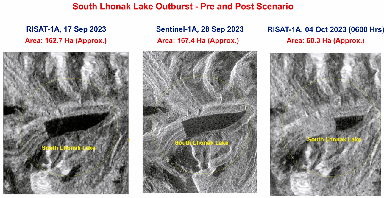
NRSC/ ISRO conducted a study of the surface area of the South Lhonak lake using a set of three pre- and post- disaster imagery from the RISAT–1A and the SENTINEL-1A satellites, covering a short duration of 17 days from September 17, 2023 to October 4, 2023 at (0600 hrs). During the 11 days between September 17, 2023 and September 28, 2023, the surface area of South Lhonak lake increased at an alarming rate from 162.7 hectare (approx.) to 167.4 hectare (approx.), increase of about 4.7 hectare.
On October 4, 2023 at (0600 hrs) the surface area of South Lhonak lake suddenly shrunk to 60.3 hectare (approx.). The maximum depth of the lake is estimated at 79.24 m. Thus, instant draining of about 107.3 hectares lake area suddenly released enormous volume of water into the Lachen River which in turn quickly transferred it into the Teesta River at Chungthang, followed by the disastrous consequences. On a rough estimate taking the average depth of the lake as 40m, the reduction of 107.3 hectare in the surface area of the South Lhonak Lake due to the dam failure will mean a sudden discharge of about 43 million cubic meter volume of water. The fury of such stupendous volume of water rushing down the steeply inclined, somewhat narrow river channels is anybody’s guess.
The gross underestimation of potential threat:
The rapidly increasing rate of expansion of the South Lhonak glacial lake over the past few decades was well recorded by several researchers and other agencies. Thus, the possibility a GLOF was quite well understood. Moreover, the presence of an ambitious hydroelectric project just downstream of the confluence of the Lachen and Lachung rivers at Chungthang town demanded serious consideration and more than adequate measures to prevent the catastrophe and mitigate the losses of life and property.
Adequate measures to drain off sufficient volume of water from the South Lhonak lake were not taken while the catastrophe was waiting to happen. It just needed a trigger which was finally provided by the cloud burs and devastation followed.


Leave a comment