‘Natural’ tussles in Himalayas?
Some may call it an avalanche while still others call it a Glacial Lake Flood Outburst (GLOF); some believe it to be a result of human-induced climate change while others believe it to be a natural phenomenon... the fact is a wake-up siren is buzzing, we must take heed...
Himanshi Shukla
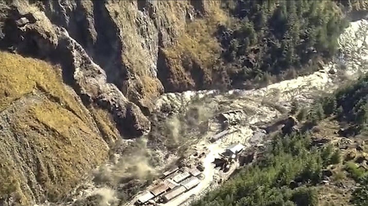
At least 38 persons were reported dead recently while more than 204 reported missing in the aftermath of what was termed as a “glacial burst” on the Nanda Devi Glacier by the Centre’s National Crisis Management Committee (NCMC). Unfortunately, the toll is expected to rise. The burst triggered an avalanche and flash floods in the Rishiganga and Dhauliganga Rivers in Uttarakhand’s Joshimath area in Chamoli District. The gush of water swept away two key hydropower projects in the district- NTPC’s 520 MW TapovanVishnugad Power Project on Dhauliganga River and the Rishiganga Hydel Project of 13.2 MW. Other projects on the Alaknanda River and Bhagirathi River were also impacted by the flood. A motorable road and four bridges dotting around eight to 10 villages were also severely damaged, compromising the accessibility to the villages. Over 35 persons were reported to be stranded in a tunnel that was blocked by debris at the under-construction TapovanVishnugad Project. The incident brought back the memories of the 2013 Uttarakhand Tragedy in which raging waters of the Rishiganga river claimed more than 5000 lives in the Kedarnath Valley. Fortunately, the prospects of downstream flooding and the rise in water level were contained by that evening, as reported by the Central Water Commission.
Action by the Authorities
High alert was immediately issued in districts Pauri, Tehri, Rudraprayag, Haridwar and Dehradun. Uttar Pradesh also issued high alert in the downstream districts dotting the Ganga River. “As a precautionary measure, water level in Bhagirathi River was regulated to streamline the intensity of the flow,” Uttarakhand’s Chief Minister Trivendra Singh Rawat said. ITBP set up their control room and 450 personnel of ITBP with all necessary equipment were engaged in rescue and relief operation. The ITBP rescued 12 persons from a tunnel. While a team of the National Disaster Response Force (NDRF) was flown from Hindon airbase, Ghaziabad, Uttarakhand’s State Disaster Response Force (SDRF) was also roped in. Food supplies were ensured in the surrounding villages by means of army helicopters. “A team from DRDO, which monitors avalanches- Snow & Avalanche Study Establishment (SASE) - was flown in for surveillance and reconnaissance,” the Press Information Bureau reported. Wadia Institute of Himalayan Geology also sent a team for study. “Eight teams of Indian Army, including one Engineer Task Force (ETF), are carrying rescue operation at incident site. One Medical column with two ambulances also deployed. One diving team of Indian Navy has also reached at incident site for rescue operation. 5 helicopters of Indian Air Force have also been engaged in rescue operation. A Control Room has been established at Joshimath,” said a statement issued by the Home Ministry to the Press Information Bureau.
A look into the possible causes
Home Minister Amit Shah in a statement in the Parliament said: “Satellite imagery from the Planetlabs indicated that the landslide-avalanche event at an altitude of 5600 metres occurred in a glacier in the Rishiganga catchment covered area of over 14 square kilometre which caused the floods.” Scientists and experts seem to be divided on the issue- some calling it an avalanche while still others calling it a Glacial Lake Flood Outburst (GLOF); some believe it to be a result of human-induced climate change while others believe it to be a natural phenomenon. DRDO’s SASE team for reconnaissance study is yet to conclusively pinpoint the actual cause. The Space Application Centre of ISRO has claimed it to be an avalanche.
Dr Sudeep K Paul, senior scientist at Wadia Institute Himalayan Geology, attributed it to be a ‘natural phenomenon’. “There was heavy snowfall on the days before the disaster which triggered an avalanche. Such avalanches are a common occurrence in the snow-capped rugged Himalayas but it gets highlighted in the media when it takes shape of a disaster and there are causalities,” he stated. Talking about the nature of the Himalayan Topography, he further added: “Various tectonic forces are at play and the rocks keep crushing against each other which triggers phenomenon such as avalanches, landslides, etc in the region. This is a natural phenomenon: it has occurred in the past and will occur again- all we can do is to minimise the risk to lives and property and take preventive measures.” Dr Abdhesh Gangwar, scientist, Himalaya Initiative, Centre for Environment Education, also pointed out the possibilities of an avalanche. “The debris kept on collecting and owing to the steep slope and increasing volume and velocity, it soon caused a catastrophic flood,” he said.
On the other hand, a different possibility much talked about in the news was Glacial Lake Flood Outburst (GLOF). This phenomenon occurs when retreating glaciers form lake at their tips which are only held in their place by moraines. If this arrangement is somehow ruptured, it causes a sudden release of water into the streams and rivers connected to the glacier. The gush of water brings down with itself sediments, debris, scree and floods the downstream areas.
But was it just natural?
Dr Gyaneshwer Shukla, Naturalist, begged to differ. “In today’s world, where anthropogenic activities have caused global warming which has in turn caused climate change, nothing can be termed as ‘natural disaster’, except of course the fall of meteors and asteroids on earth. Every action and reaction is now man-made. I hope that we learn from these frequently occurring mishaps and limit our pursuit to conquer Mother Earth,” he stated. Dr Vibhuti Rai, Environmentalist and Associate Professor, Department of Geology, Lucknow University, had another interesting viewpoint to offer. “It was not at all a natural disaster. Rather, it was a natural process which due to our intrusion converted into a natural disaster.”
While not having any direct links to the disaster, the construction activities, especially large-scale dams in such a fragile ecology do raise some serious questions about climate change factor. As per the National Disaster Management Authority (NDMA) guidelines on GLOF issued in October 2020, glacial retreat due to global warming and climate change is increasingly causing the formation of glacial lakes. The role of the topography of the region and reasons why environmentalists oppose large scale construction activities.
Chamoli District falls in the lap of the mighty Himalayas in the Garhwal region of Uttarakhand. With elevation ranging from 800 metres to 8000 metres above the mean sea level, it has a rugged terrain and steep topography. The state is home to the second highest Mountain peak of India- the Nanda Devi (7816 metres), the ecologically sensitive Valley of Flowers National Park and important pilgrimage sites like Badrinath and Hemkund Sahib. This automatically entails that a major thrust is given to the tourism sector which creates even more pressure on the already sensitive ecology.
Cite we must, late Dr KS Valdiya, eminent Geologist, who pioneered extensive research on the fragile ecosystem of the Himalayan region. He wrote in Current Science in 2014 about how the Peninsular India pressing against the Lesser Himalayas created geological tension making the region sensitive to any interventions or alterations. This has been happening since the Main Central Thrust (MCT- the connecting point of the Indian and Eurasian Tectonic plates) was formed 20 million years ago. The feeble rocks are thus a consequence of the tectonic movements taking place. This is the exact reason why the height of the Himalayan peak keeps on increasing from time to time. They are, in fact still in the making. Among the key concerns is also the active tectonic faults in the region which make the region earthquake prone and create massive instability especially along the slopes. This geological uniqueness of the lesser Himalayas calls for greater vigilance and foresight before any major construction projects are undertaken in the region. This is the primary reason why experts oppose the construction of dams, roads, expressways, habitations, etc or other activities like mining and quarrying.
Professor CP Rajendran remarked: “The government has transformed this whole region into a resource frontier devoid of any ecological value, treating it as a barren wilderness that could be the source of supposedly low-carbon energy.” Dr Gyaneshwer Shukla remarked: “Construction activity and large-scale infrastructure create irreplaceable loss of macro and micro flora and fauna, some of which species, types and varieties may not have been reported in Scientific literature. Hence megastructures shouldn’t be constructed in sensitive zones.”
The classic case of the Tehri Dam on the Bhagirathi River should be mentioned here. The tallest dam of India, it falls in the Central Himalayan Seismic Gap- a major geological fault zone. It was vehemently opposed by activists. Virendra Nath Saklani formed an Anti-Tehri Dam struggle committee while renowned environmental activist Sunder Lal Bahuguna led the anti-Tehri Dam movement from 1980s to 2004. To its credit, the dam has survived a 6.8 magnitude earthquake in 1991 whose epicentre was approximately 50 kilometres from the dam. Those who support the dam claim that it can survive even up to 8.5 magnitude earthquake on the Richter scale (which on account of the fragile topography is very much a possibility), but fail to paint their imagination of what the likely scenario would be like if even greater intensity earthquake hits the area. Mention may also be made of the possibilities of a dam-induced earthquake due to regular filling and emptying of the dam.
Regular petitions have been filed against several projects not only by the activists but also by the residents of the area. In 2019, Kundan Singh, a resident of the Reni Village of Chamoli District in Uttarakhand filed a PIL in the Uttarakhand High court against the Rishiganga Power project- that it endangered the ecosystem of the area and infringed upon the rights of the residents of the village.
No warnings heeded
The Supreme Court imposed a ban on dam construction after the devastating 2013 floods in the state. A committee set up by the Supreme Court of India- the Ravi Chopra Committee on Environmental Impact Assessment (EIA) had recommended the closure of as many as fourteen dams in the region. The committee also noted how developmental activities like roads, dams, bridges, tunnels have increased the vulnerability of both the ecosystem and the population. Both the NTPC Tapovan-Vishnugad Power Project and the Rishiganga project were in a list of 13 dams which were red-flagged at a meeting in the Prime Minister’s Office two years ago, as reported by the Indian Express. Records show that the meeting had ordered a permanent ban on any new hydro-electric project on the River Ganga or any of its tributaries. It had also frozen such constructions which had not reached the half way mark and had warned against sand-mining and boulder crushing. But these warnings were not heeded due to “developmental” concerns by the state government- energy security and employment generation in the state.
According to the Hindu Kush Himalaya Assessment Report (titled: “Mountain, Climate Change, Sustainability and People”) released by the International Centre for Integrated Mountain Development (ICIMOD) on 5th June 2020, even the most ambitious goal set by the Paris Agreement to limit global warming would lead to a 2.1-degree Celsius spike in temperature in the Hindu Kush Himalayan Region, leading to melting of 1/3 of the region’s glaciers by 2100, potentially destabilizing Asia’s rivers. But if the greenhouse gas emissions continue at their current level, the region can lose up to 2/3rd of its ice. The Hindu Kush Himalayan region forms the largest area of permanent ice cover outside of the North and South Poles and so it is often referred to as the “Third Pole”. The melting of these glaciers will threaten 1.9 billion lives, not to mention the havoc on the flora and fauna. “Since the 1970’s about 15% of the ice in the region has disappeared due to temperature rise that can be attributed to anthropogenic activities,” the report stated.
The Intergovernmental Panel on Climate Change (IPCC) released a special report in 2020 titled “Special Report on the Ocean and Cryosphere in a changing climate (SROCC)”. The report stated: “By the end of the century, glaciers are projected to lose around 18% of their mass compared to the 2015 levels under a low emissions scenario and around a third under a high-emissions scenario.” The report further warned: “Due to a ‘pronounced imbalance’ between the current glacier mass and the climate, glaciers will continue to melt even with no further climate change.” A detailed report was also brought out by the esteemed Divecha Centre for Climate Change, Bengaluru in 2018. As per the report “the average temperature in the north-western Himalaya has risen by 0.66º C since 1991 – an increase much higher than the global average. The higher Himalaya became even warmer on average in the same period.” Researchers from the Snow and Avalanche Study establishment (SASE) too concluded that winters in the northwest Himalayas have been getting warmer and wetter in the past 25 years.
Professor CP Rajendran, adjunct professor, the National Institute of Advanced Studies, remarked: “These findings together indicate that a region that has for many millennia been marked by its extreme cold in the winter is already started exhibiting completely opposite trends. So, the Chamoli flood was simply waiting to happen, and the science tells us that there is every chance such incidents will only become more common in the Himalayas. Infrastructure projects like the various power projects affect the region first when they are constructed – and then when they come in the way of powerful natural forces. Put another way, high-velocity flows turn into disasters when they have to mediate with the built-environment present in the way. The Chamoli disaster is no exception to this rule, and this is why it should be treated as yet another warning against the unregulated construction throughout Uttarakhand’s river valleys and floodplains.”
Prevention is better than Destruction
Glaciologists believe that several parameters in glaciers- the ice caps, change in water levels, discharge in river water, etc can be monitored and events like glacier lake floods can be forecasted. Dr Anil V Kulkarni, eminent glaciologist at Divecha Centre for Climate Change, IISC Bengaluru said: “Glacier lake floods can be prevented provided the event is monitored and timely forecasted. The danger can be averted by constructing a drainage that discharges the water in a regulated manner.” The NDMA guidelines on glacier lakes risk reduction states measures such as identifying and mapping these lakes by Synthetic Radar Aperture imaging, monitoring their water levels and taking measures to prevent a sudden breach. It also states mechanism to save lives and property in case a breach does occur. Overall, the guidelines give a thrust on prevention of the breach which involves controlled breaching, siphoning of water and making an artificial tunnel beneath the moraine barrier for timely discharge of water. Most importantly, the guidelines talk about the importance of land use planning.
In the cases of avalanche, Dr Vibhuti Rai suggests Sound Bombing which is a regular process in other countries. Sound Bombing technology ensures the scree, lose ice and sediments are detached and this literally prevents ‘snowballing’ of the catastrophe. Dr Abdhesh Gangwar pointed out the importance of Sendai Framework for Disaster Risk Reduction (2015-2030). “Every citizen down to the grassroots level should be made aware of Disaster Risk Reduction (DRR). The policy framework already exists in the form of National Disaster Management Act, 2005. The Government should make huge investments in DRR,” he said. He further added: “There is no reason why India shouldn’t cooperate internationally and learn from the experiences of advanced countries like Japan which have disaster resilient infrastructure and excellent early warning systems in place. The launch of Coalition for Disaster Resilient Infrastructure by PM Modi is an important step in this direction.” Dr Gangwar also pointed out the importance of citizen centric, decentralised way to tackle such problems. “Every Gram Panchayat should have a village Disaster Management Plan as well as a Disaster Risk Reduction Plan as we have at the state and national levels. This will ensure that there are no one-size-fits-all approach and people are prepared at the grassroots level.”
Experts also pointed out that the Hydel projects affected should have had robust safety mechanisms and disaster-resilient infrastructure. “It is hard to believe that a 1.9 km tunnel at Tapovan where many labourers are trapped didn’t have any escape routes or safety nets. Such huge scale projects in sensitive areas should themselves ensure that they are so built that they can withstand even the worse situations,” wondered Dr Vibhuti Rai. It is pertinent to mention that due to traditional wisdom, the houses along the Rishiganga and the Dhauliganga Rivers were constructed at a height and thus were prevented from being swept away and every one of them survived the floods.
No early warning system in place
Unlike other disasters like cyclones, heatwaves, Tsunami or floods, where India has reaped the benefits of an early warning system, the same cannot be said for avalanches or GLOF events. The reasons for the same are not far to seek!
The most important reason being that responsibility of glaciers is spread across numerous stakeholders- many government departments and there is no nodal agency to even coordinate them. There has been a proposal for a National Centre for Glaciology but it has only been resting on the table. To understand the complexity of the situation, we must understand that rainfall comes under Indian Meteorological Department under Ministry of Earth Sciences, Remote sensing by the National Remote sensing agency (NRSA) of ISRO, Avalanches are monitored by Snow and Avalanche Study Establishment (SASE) of DRDO, Hydrology comes under State Irrigation department, Scientific Research is undertaken by the Department Of Science and Technology of Science Ministry, Climate Change studies are undertaken by the Ministry of Environment, Forests and Climate Change, while Ministry of Mines’ Geological Survey of India is responsible for surveying and mapping.
Second problem is of technology. Dr Abdhesh Gangwar remarked: “What better than remote sensing but there aren’t many facilities and not many experts to interpret the data.” Dr Sudeep Paul pointed out: “SASE of DRDO monitors the glaciers but we have to understand the complexities involved in the monitoring. Monitoring 2500 km of Himalayan terrain is definitely a monumental task. Generally, the focus is on red-alert areas and not on every glacier. In my opinion, satellites should be upgraded and the facility should be expanded.” Dr Vibhuti Rai added: “A distinct system should be evolved for a distinct terrain. But before that the existing technology should be used properly. There should be regular monitoring of glacier-fed rivers. The Digital Water Level Recorders (DWLRs), normally used for ground-water can also be utilised for surface levels. Since it operates on a battery and uses a sim card, it will automatically signal the server in case of an anomaly.” Dr. Rai also pointed out that robust communication networks must be established so as to aid in early evacuation of people and avert causalities. “I suggest using laser-guided systems for the same. It must be a while before the gush of water reached from one impact site to the other. The question we must ask is why wasn’t this communicated timely and why weren’t alerts issued immediately?”
Funding of the research and technology is also a major constraint. For this, Dr Rai suggested: “The private entities or even the government corporations like NTPC must aid the research so that safety standards are in place.” Mention may be made of Nepal and China which installed sensor and monitoring based technical systems for early warning of GLOF and this has proved effective at least on three occasions.
The Way Forward
Dr Gyaneshwer Shukla sums it all up. “All the work in sensitive Himalayan should be restricted to what can be done by manual labour. No gigantic, mechanical engineering equipment like earth-movers, drillers, engines should be used in these areas. Power projects should be reduced to generate only minimal essential quantum. No large structures, dams etc. should be made from now on. Hills cannot have living facility and lifestyle of modern urban megacities. People in hill areas are accustomed to live in their vicinity. They should be allowed to live as they were living. Religious tourism should be allowed to continue as in the past with limited resources and time/season, only, without mechanization or automobile etc. Pilgrimage) shouldn't be mingled with commercial tourism). Religious tours follow traditions and certain regulations specific for conservation and sustainability of the region, season and ethics. There is a reason why they don’t happen round the year. Whereas, tourism is an activity of leisure and luxury, not following any restrictions but even violating the local ethics and norms. If need be, ropeways can be constructed instead of roadways for access to pilgrimage sites. Consumerism shouldn’t be promoted. The Sanatan culture developed in this region and the Devbhoomi is a part of our cultural and religious heritage. Exploitation in the name of tourism and development should be minimal. To cite the example of Goa, where local people sometimes object and protest against excessive tourism, claiming to conserve the local culture and ethics. We should respect the nature as it is and should not try to exploit it for consumerism.”
Chipko to Chamoli
Raini Village in Chamoli District of Uttarakhand, nearly 50 years after it cradled the famous Chipko Movement also found itself trapped in the tragedy. After inspiring a range of ecological and environmental movements, it again faces a major challenge to protect its flora, fauna and people. The movement sowed seeds of oneness of Humans and Mother Nature- it taught us that we are one and the same; That trees weren’t for us to be exploited but cherished. But despite being a part of our textbooks, and Sunderlal Bahuguna being a household name, we seem to have forgotten the essence of the movement. That we do not inherit the earth from our ancestors, we borrow it from our children.


Leave a comment